METAR & TAF 51R
51R does not publish a METAR.
Showing the nearest reporting station: KUTS (HUNTSVILLE MUNI) · 21.3 NM away. Conditions at 51R may differ.
METAR · KUTS
Observed 03:53Z
KUTS 270353Z AUTO 18004KT 10SM FEW043 29/25 A2999 RMK AO1 SLP150 T02890250
- Wind
- 180° @ 4 kt
- Visibility
- 10 SM
- Temp / Dew
- 29°C / 25°C
- Altimeter
- 29.99 inHg
- Clouds
- FEW
- Density alt
- 1,948 ft
- Ceiling
- Unlimited
- Rules
- VFR
Airport info & contacts
Manager on record, flight service, ARTCC, attendance schedule and pattern altitude — published by the FAA and refreshed every 28 days.
Location
- From city
- 3 NM SW
- VFR sectional
- HOUSTON
- ARTCC
- ZHU · HOUSTON
- NOTAM facility
- CXO (NOTAM-D)
Airport manager
- Name
- KELCEY YOUNG
- Phone
- 936-307-3997
- Address
- 210 W. COTTONWOOD, MADISONVILLE TX 77864
Flight service · Hours
- FSS CXO
- MONTGOMERY COUNTY1-800-WX-BRIEF
- Attendance
- Unattended
Frequencies
Tap any row to copy the frequency to your clipboard.
Runways & pattern
Full pagePattern entry · RWY 19
LEFT TRAFFICRunway end performance
| End | TORA | TODA | ASDA | LDA | VGSI | Approach lights | Obstruction |
|---|---|---|---|---|---|---|---|
| 01 | — | — | — | — | — | — | 42', trees, 201' from thr, 232' R of cntrln, slope 0 |
| 19 | — | — | — | — | — | — | 76', trees, 201' from thr, 206' R of cntrln, slope 0 |
Declared distances in feet. TORA = takeoff run available, TODA = takeoff distance, ASDA = accelerate-stop, LDA = landing distance.
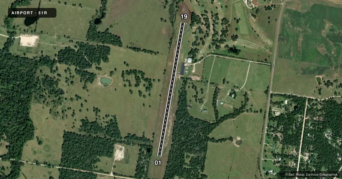
Airport sketch
Runways drawn to scale from FAA survey coordinates, rendered over satellite imagery. Not for navigation.
Approaches & charts
Services on the field
Fuel grades, oxygen, maintenance, ramp storage and lighting — as declared to the FAA by the airport operator.
Fuel & services
- Fuel
- 100LL
- Oxygen (bottled)
- Not available
- Oxygen (bulk)
- Not available
- Airframe repair
- Not available
- Power plant repair
- Not available
- Other services
- INSTR
Ramp & ground
- Transient storage
- Tie-down
- Landing fee
- No fee published
- Customs
- Not available
- Lighting schedule
- SS-SR
- Beacon schedule
- SS-SR
- Beacon
- White / Green (civil land)(WG)
- Wind indicator
- Lighted
- Segmented circle
- Yes
Fuel & FBOs
Cheapest 100LL and Jet A on the field and nearby. Always confirm with the FBO before taxi.
Airport notes
Surface conditions, obstructions, local procedures, lighting outages and other notes published with each FAA cycle.
General notes
- AIRPORT GATE LOCKED FROM 2200-0600 CALL 936-348-2748.
- FOR CD CTC HOUSTON ARTCC AT 281-230-5622.
Approach & departure obstructions
- 0140 FT TREES, 0-199 FT DSTC,188 FT L/R.
- 1935 FT TREES, 0-199 FT DSTC,188 FT L/R.
- 01CONTROLLING OBSTRUCTION EXCEEDS A 45 DEGREE SLOPE
Other notes
- MANAGERCITYMANAGER@CI.MADISONVILLE.TX.US
VFR map & nearby airports
VFR sectional. Tap any ICAO chip to open that airport.
Key facts · 51R
Answer card- ICAO
- 51R
- Name
- MADISONVILLE MUNI
- Location
- MADISONVILLE, TEXAS
- Elevation
- 286.4 ft MSL
- Traffic pattern altitude
- 1,286.4 ft MSL (1,000 AGL)
- Control tower
- Non-towered (use CTAF)
- Total runways
- 1
- Longest runway
- 01/19 · 3,205 ft
- Published ILS approaches
- 0
- Published frequencies
- 1
- Magnetic variation
- 2°
- Current flight rules
- VFR
- Current wind
- 180° at 4 kt
- Favored runway now
- RWY 19
Madisonville Muni sits in Madisonville, Texas. Field elevation is 286.4 ft MSL. It has one runway, 01/19 and the longest runway is 3,205 ft of asphalt. There is no control tower. CTAF is 122.9.
No ILS approaches are published here. Pattern altitude is not published in the facts, so use the current Chart Supplement before arrival and confirm your pattern plan with local traffic. The published remarks also matter here. Clearance delivery goes through Houston ARTCC at 281-230-5622. The airport gate is locked from 2200 to 0600, so plan ground access before you go in after hours.
The runway environment has close-in trees and other obstructions near both ends. The runway 01 end has a controlling obstruction that exceeds a 45 degree slope. Trees are also listed near runway 01 and runway 19. That makes a careful look at winds, takeoff performance and landing distance a good idea before you commit. With no tower and no on-field FBOs listed, this is a self-briefing airport. Check the current Chart Supplement for any noise or curfew restrictions before flying into the field.