METAR & TAF KLHB
Current METAR
Observed 05:35Z
KLHB 270535Z AUTO 15005KT 10SM CLR 27/25 A2997 RMK AO2
- Wind
- 150° @ 5 kt
- Visibility
- 10 SM
- Temp / Dew
- 27°C / 25°C
- Altimeter
- 29.97 inHg
- Clouds
- CLR
- Density alt
- 1,731 ft
- Ceiling
- Unlimited
- Rules
- VFR
Airport info & contacts
Manager on record, flight service, ARTCC, attendance schedule and pattern altitude — published by the FAA and refreshed every 28 days.
Location
- From city
- 1 NM SW
- VFR sectional
- HOUSTON
- ARTCC
- ZHU · HOUSTON
- NOTAM facility
- LHB (NOTAM-D)
Airport manager
- Name
- ALANZO ECHAVARRIA
- Phone
- 979-279-3461
- Address
- 209 CEDAR ST., HEARNE TX 77859
Flight service · Hours
- FSS CXO
- MONTGOMERY COUNTY1-800-WX-BRIEF
- Attendance
- Unattended
Frequencies
Tap any row to copy the frequency to your clipboard.
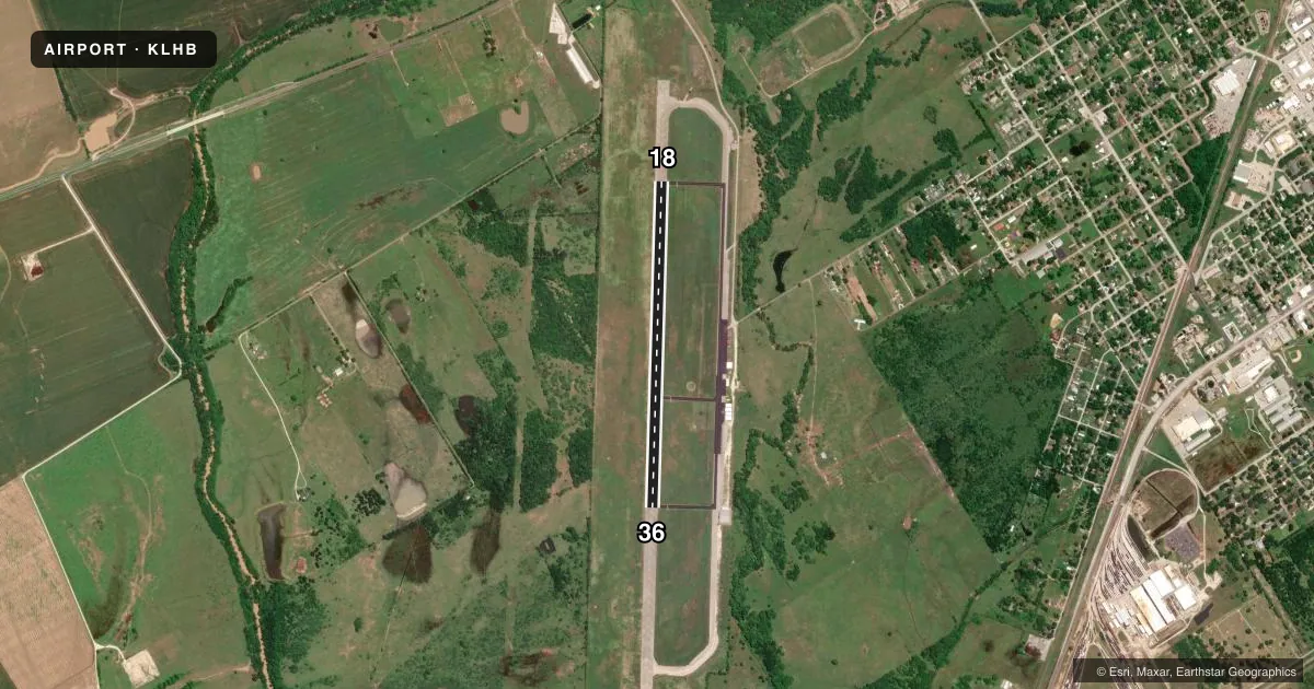
Runways & pattern
Full pagePattern entry · RWY 18
LEFT TRAFFICAirport sketch
Runways drawn to scale from FAA survey coordinates, rendered over satellite imagery. Not for navigation.
Approaches & charts
Services on the field
Fuel grades, oxygen, maintenance, ramp storage and lighting — as declared to the FAA by the airport operator.
Fuel & services
- Fuel
- 100LL
- Oxygen (bottled)
- Not available
- Oxygen (bulk)
- Not available
- Other services
- AGRI
Ramp & ground
- Transient storage
- Tie-down
- Landing fee
- No fee published
- Customs
- Not available
- Lighting schedule
- SEE RMK
- Beacon schedule
- SS-SR
- Beacon
- White / Green (civil land)(WG)
- Wind indicator
- Lighted
- Segmented circle
- Yes
Fuel & FBOs
Cheapest 100LL and Jet A on the field and nearby. Always confirm with the FBO before taxi.
Airport notes
Surface conditions, obstructions, local procedures, lighting outages and other notes published with each FAA cycle.
General notes
- FOR CD CTC HOUSTON APCH AT 281-443-5844 TO CNL IFR CALL 281-443-5888.
Lighting notes
- MIRL RWY 18/36 PRESET LOW INTST; TO INCR INTST ACTVT - 123.3.
Approach & departure obstructions
- 18RWY MKGS FADED.
- 36RWY MKGS FADED.
Other notes
- MANAGERCITY/ARPT MGR.
VFR map & nearby airports
VFR sectional. Tap any ICAO chip to open that airport.
Key facts · KLHB
Answer card- ICAO
- KLHB
- Name
- HEARNE MUNI
- Location
- HEARNE, TEXAS
- Elevation
- 284.7 ft MSL
- Traffic pattern altitude
- 1,284.7 ft MSL (1,000 AGL)
- Control tower
- Non-towered (use CTAF)
- Total runways
- 1
- Longest runway
- 18/36 · 4,001 ft
- Published ILS approaches
- 0
- Published frequencies
- 3
- Magnetic variation
- 4°
- Current flight rules
- VFR
- Current wind
- 150° at 5 kt
- Favored runway now
- RWY 18
Hearne Muni sits in Hearne, Texas. Field elevation is 284.7 ft MSL. The airport has one runway, 18/36, at 4,001 ft asphalt. There is no control tower. Houston Approach handles IFR clearance delivery and departure work. No ILS approaches are published here.
Pattern altitude is not published. Use the standard 1,000 ft AGL for light piston traffic unless the current Chart Supplement says otherwise. That puts the pattern at about 1,285 ft MSL based on the field elevation, but verify before you fly. Runway markings on both 18 and 36 are faded. The medium intensity runway lights are preset to low intensity. Use 123.3 to step them up.
There are no on-field FBOs listed. Contact the airport operator directly before arrival if you need services on the ground. CTAF is 122.9. The published remarks also note the city and airport manager as the point of contact. For IFR work, Houston Approach can be reached for clearance delivery at 281-443-5844. To cancel IFR, call 281-443-5888. First-time arrivals should plan for an uncontrolled field with a single short asphalt runway and verify current procedures before launch.