METAR & TAF KCFD
Current METAR
Observed 11:35Z
KCFD 271135Z AUTO 00000KT 10SM OVC011 25/24 A3001 RMK AO2 T02460237 PWINO
- Wind
- 000° @ 0 kt
- Visibility
- 10 SM
- Temp / Dew
- 25°C / 24°C
- Altimeter
- 30.01 inHg
- Clouds
- OVC
- Density alt
- 1,543 ft
- Ceiling
- 1,100 ft AGL
- Rules
- MVFR
Airport info & contacts
Manager on record, flight service, ARTCC, attendance schedule and pattern altitude — published by the FAA and refreshed every 28 days.
Location
- From city
- 3 NM NE
- VFR sectional
- HOUSTON
- ARTCC
- ZHU · HOUSTON
- NOTAM facility
- CFD (NOTAM-D)
Airport manager
- Name
- BRANDON REID
- Phone
- 979-209-5233
- Address
- 6120 SH 21E, BRYAN TX 77808
Flight service · Hours
- FSS CXO
- MONTGOMERY COUNTY1-800-WX-BRIEF
- Attendance
- MON-FRI · 0700-1800
- SAT-SUN · 0900-1730
Frequencies
Tap any row to copy the frequency to your clipboard.
Runways & pattern
Full pagePattern entry · RWY 15
LEFT TRAFFICRunway end performance
| End | TORA | TODA | ASDA | LDA | VGSI | Approach lights | Obstruction |
|---|---|---|---|---|---|---|---|
| 15 | — | — | — | — | PAPI 2-box left(3.5°) | — | 27', trees, 625' from thr, 304' R of cntrln, slope 15 |
| 33 | — | — | — | — | PAPI 2-box left(3.5°) | — | 8', road, 300' from thr, 365' R of cntrln, slope 12 |
Declared distances in feet. TORA = takeoff run available, TODA = takeoff distance, ASDA = accelerate-stop, LDA = landing distance.
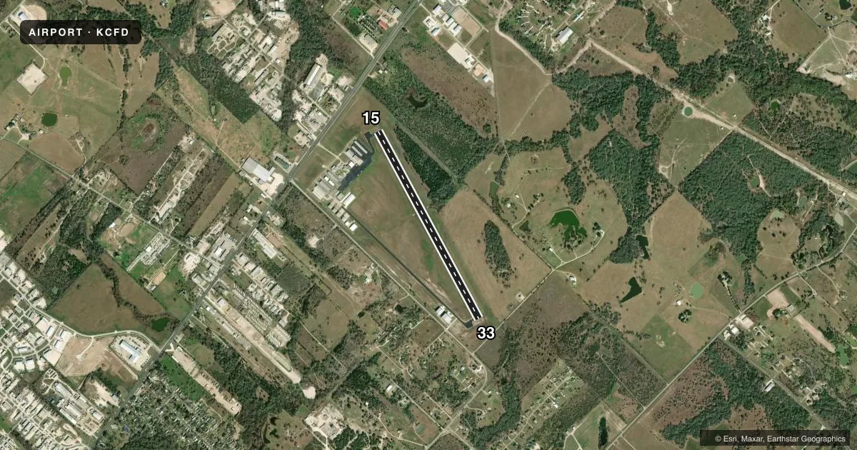
Airport sketch
Runways drawn to scale from FAA survey coordinates, rendered over satellite imagery. Not for navigation.
Approaches & charts
Services on the field
Fuel grades, oxygen, maintenance, ramp storage and lighting — as declared to the FAA by the airport operator.
Fuel & services
- Fuel
- 100LLA+
- Oxygen (bulk)
- Not available
- Airframe repair
- Major
- Power plant repair
- Major
Ramp & ground
- Transient storage
- Tie-down
- Landing fee
- No fee published
- Customs
- Not available
- Lighting schedule
- SEE RMK
- Beacon schedule
- SS-SR
- Beacon
- White / Green (civil land)(WG)
- Wind indicator
- Lighted
- Segmented circle
- Yes
Fuel & FBOs
Cheapest 100LL and Jet A on the field and nearby. Always confirm with the FBO before taxi.
Airport notes
Surface conditions, obstructions, local procedures, lighting outages and other notes published with each FAA cycle.
General notes
- UNLGTD HNGRS 450 FT SW AER 15.
- FOR CD CTC HOUSTON APCH AT 281-443-5844 TO CNL IFR CALL 281-443-5888.
Lighting notes
- SR-SS MIRL RWY 15/33 PRESET LOW INTST; TO ACTVT OR INCR INTST - CTAF.
Other notes
- THIS AIRPORT HAS BEEN SURVEYED BY THE NATIONAL GEODETIC SURVEY.
- PRE DATES THE ACT.
- UNLGTD SUPPLEMENTAL WINDSOCK 460 FT SW AER 15.
VFR map & nearby airports
VFR sectional. Tap any ICAO chip to open that airport.
Key facts · KCFD
Answer card- ICAO
- KCFD
- Name
- COULTER FLD
- Location
- BRYAN, TEXAS
- Elevation
- 366.7 ft MSL
- Traffic pattern altitude
- 1,366.7 ft MSL (1,000 AGL)
- Control tower
- Non-towered (use CTAF)
- Total runways
- 1
- Longest runway
- 15/33 · 4,000 ft
- Published ILS approaches
- 0
- Published frequencies
- 4
- Magnetic variation
- 4°
- Current flight rules
- MVFR
- Current wind
- 000° at 0 kt
- Favored runway now
- –
Coulter Field sits in Bryan, Texas. Field elevation is 366.7 ft MSL. The airport has one runway. Runway 15/33 is 4,000 ft asphalt and is the longest runway on the field. There is no control tower. Pattern altitude is not published, so use 1,000 ft AGL for light piston operations unless the current Chart Supplement says otherwise.
No ILS approaches are published here. CTAF and UNICOM are both 123.0. Houston Approach handles IFR services on 134.3 and 360.85. For clearance delivery, the published remarks direct pilots to Houston Approach. The field is served by Coulter Field FBO. It carries 100LL and Jet A Prist.
A few remarks matter on arrival. The controlling obstruction exceeds a 45 degree slope at the runway 15 end. There are unlighted hangars and an unlighted supplemental windsock southwest of that approach end. From dusk to dawn, the medium intensity runway lights on 15/33 start at low intensity. Use CTAF to increase them. Deer are on and near the airport. Keep a sharp scan on taxi, takeoff and landing. This is a good field to brief carefully before descent, especially if you are coming in at night or in IFR conditions.