METAR & TAF KCLL
Current METAR
Observed 13:32Z
KCLL 271332Z 19005KT 10SM FEW007 27/24 A3000 RMK AO2 T02670244
- Wind
- 190° @ 5 kt
- Visibility
- 10 SM
- Temp / Dew
- 27°C / 24°C
- Altimeter
- 30.00 inHg
- Clouds
- FEW
- Density alt
- 1,738 ft
- Ceiling
- Unlimited
- Rules
- VFR
Airport info & contacts
Manager on record, flight service, ARTCC, attendance schedule and pattern altitude — published by the FAA and refreshed every 28 days.
Location
- From city
- 3 NM SW
- VFR sectional
- HOUSTON
- ARTCC
- ZHU · HOUSTON
- NOTAM facility
- CLL (NOTAM-D)
Airport manager
- Name
- KEVIN DAVIS
- Phone
- 979-775-9901
- Address
- 1 MCKENZIE TERMINAL BLVD, SUITE 112, COLLEGE STATION TX 77845
Flight service · Hours
- FSS CXO
- MONTGOMERY COUNTY1-800-WX-BRIEF
- Attendance
- 0600-2200
Frequencies
Tap any row to copy the frequency to your clipboard.
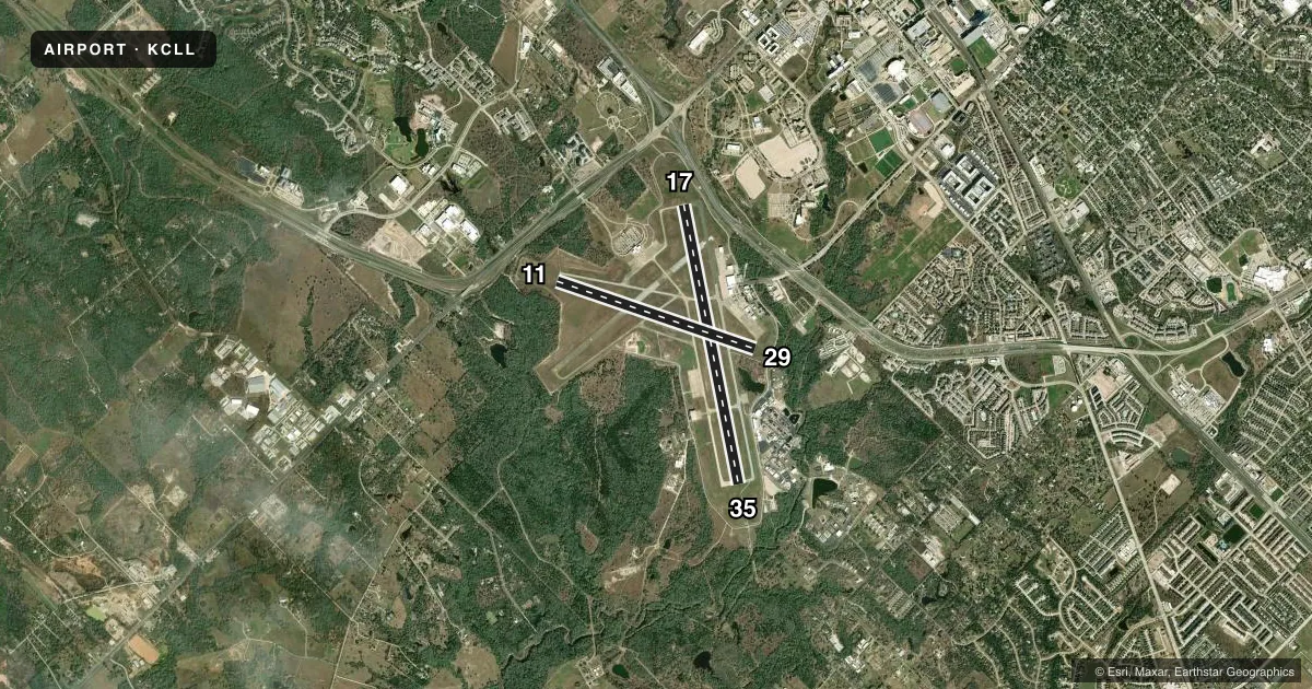
Runways & pattern
Full pagePattern entry · RWY 17
LEFT TRAFFIC| Runway | Heading (°M) | Length | Surface | Traffic |
|---|---|---|---|---|
| 17/35Favored | 166° / 346° | 7,000 ft | ASPH-CONC | Standard L |
| 11/29 | 106° / 286° | 5,158 ft | ASPH | Standard L |
Runway end performance
| End | TORA | TODA | ASDA | LDA | VGSI | Approach lights | Obstruction |
|---|---|---|---|---|---|---|---|
| 17 | 7,000' | 7,000' | 7,000' | 7,000' | VASI 4-box right(3°) | — | 42', tree, 500' from thr, 480' R of cntrln, slope 7 |
| 35 | 7,000' | 7,000' | 6,932' | 6,932' | — | MALSR | — |
| 11 | 5,158' | 5,158' | 5,158' | 5,158' | VASI 4-box left(3°) | — | 40', tree, 1180' from thr, 400' R of cntrln, slope 24 |
| 29 | 5,158' | 5,158' | 5,158' | 5,158' | VASI 4-box left(3°) | — | 18', tree, 500' from thr, 230' R of cntrln, slope 17 |
Declared distances in feet. TORA = takeoff run available, TODA = takeoff distance, ASDA = accelerate-stop, LDA = landing distance.
Airport sketch
Runways drawn to scale from FAA survey coordinates, rendered over satellite imagery. Not for navigation.
Approaches & charts
ILS · 1
Services on the field
Fuel grades, oxygen, maintenance, ramp storage and lighting — as declared to the FAA by the airport operator.
Fuel & services
- Fuel
- 100LLAA+
- Airframe repair
- Major
- Power plant repair
- Major
- Other services
- AVNCS,CHTR,INSTR
Ramp & ground
- Transient storage
- Tie-down
- Hangar
- Landing fee
- No fee published
- Customs
- Not available
- Lighting schedule
- SEE RMK
- Beacon schedule
- SS-SR
- Beacon
- White / Green (civil land)(WG)
- Wind indicator
- Lighted
- Segmented circle
- No
Fuel & FBOs
Cheapest 100LL and Jet A on the field and nearby. Always confirm with the FBO before taxi.
Airport notes
Surface conditions, obstructions, local procedures, lighting outages and other notes published with each FAA cycle.
General notes
- TURN FEE SKEDD FAR 135 AND ALL FAR 121 OPNS.
- PAEW ADJ ALL RWYS AND TWYS 0600-1600.
- SFC COND NOT RPRTD FM 1700-0500 LCA MON-FRI AND SAT-SUN.
- ALL RAPID RFL MIL HEL ADZ ATC FOR RAPID RFL OPS & PROCD TO SOUTH RAMP. CTC ASTIN AVN UNICOM 122.95 FOR SVC PRIOR TO LNDG. RAPID RFL IS AVBL 0600-2200 DLY. SPL RQS CSDRD ON CASE BY CASE BASIS.
- FOR CD IF UNA TO CTC ON FSS FREQ, CTC HOUSTON ARTCC AT 281-230-5622.
- ALL ACFT PRKG ON SE RAMP MUST CTC ASTIN AVN FOR SVC OR TRNSP, UNICOM 122.95 OR 979-775-5255.
Lighting notes
- WHEN ATCT CLSD ACTVT MALSR RWY 35; MIRL RWY 11/29; HIRL RWY 17/35 - CTAF. REIL RWY 29 PRESET LOW INTST ONLY.
Fuel notes
- 100LLFUEL SVC 0600-2200. FOR FUEL AFT HRS PPR CALL 979-775-5255. LATE NIGHT FEE.
Runway surface & condition
- 11/29PCR VALUE: 570/F/D/X/T
- 17/35PCR VALUE: 300/R/D/W/T
Other notes
- CLSD TO UNSKED ACR OPNS WITH MORE THAN 30 PSGR SEATS EXCP 24 HRS PPR CALL AMGR 979-775-9920.
- OPS DIRCABBOTT@EASTERWOODAIRPORT.COM
- 17/35FIRST 1850 FT RWY 35 CONC.
VFR map & nearby airports
VFR sectional. Tap any ICAO chip to open that airport.
Key facts · KCLL
Answer card- ICAO
- KCLL
- Name
- EASTERWOOD FLD
- Location
- COLLEGE STATION, TEXAS
- Elevation
- 320.6 ft MSL
- Traffic pattern altitude
- 1,320.6 ft MSL (1,000 AGL)
- Control tower
- Towered · 0800-2100
- Total runways
- 2
- Longest runway
- 17/35 · 7,000 ft
- Published ILS approaches
- 1
- Published frequencies
- 13
- Magnetic variation
- 3°
- Current flight rules
- VFR
- Current wind
- 190° at 5 kt
- Favored runway now
- RWY 17
Easterwood Fld sits in College Station, Texas. The field elevation is 320.6 ft MSL. It has two runways. The longest is runway 17/35 at 7,000 ft. Runway 11/29 is 5,158 ft. The tower is open 0800 to 2100. Outside those hours, lighting is pilot-controlled. Runway 35 has MALSR when the tower is closed. Runway 17/35 uses high intensity runway lights. Runway 11/29 uses medium intensity runway lights. The field has one ILS approach. It serves runway 35.
Pattern altitude is not published. Use 1,000 ft AGL for light piston traffic unless ATC or the Chart Supplement says otherwise. Astin Aviation is on the field. It carries 100LL, Jet A and Jet A Prist. Fuel service is available from 0600 to 2200. After hours fuel needs prior permission. Call the FBO before you go if you need late service.
This is a towered airport with active airline and training traffic. Expect a busy pattern. Stay sharp on runway assignments. Precision approach path indicators are available on all runways and taxiways from 0600 to 1600. Runway 35 is the main precision approach runway. Check the current FAA Chart Supplement for any noise or curfew restrictions before flying into the field. The airport also has published limits for some air carrier and charter operations. Verify special-use or transport-category plans with the airport operator before arrival.