METAR & TAF 1R4
1R4 does not publish a METAR.
Showing the nearest reporting station: KAEX (ALEXANDRIA INTL) · 12.3 NM away. Conditions at 1R4 may differ.
METAR · KAEX
Observed 02:53Z
KAEX 270253Z 00000KT 10SM CLR 28/24 A2996 RMK AO2 SLP146 T02780239 53003
- Wind
- 000° @ 0 kt
- Visibility
- 10 SM
- Temp / Dew
- 28°C / 24°C
- Altimeter
- 29.96 inHg
- Clouds
- CLR
- Density alt
- 1,684 ft
- Ceiling
- Unlimited
- Rules
- VFR
Airport info & contacts
Manager on record, flight service, ARTCC, attendance schedule and pattern altitude — published by the FAA and refreshed every 28 days.
Location
- From city
- 2 NM S
- VFR sectional
- HOUSTON
- ARTCC
- ZHU · HOUSTON
- NOTAM facility
- DRI (NOTAM-D)
Airport manager
- Name
- NICHOLAS COLE
- Phone
- 225-952-8074
- Address
- 5825 FLORIDA BLVD, SUITE 1002, BATON ROUGE LA 70806-3481
Flight service · Hours
- FSS DRI
- DE RIDDER1-800-WX-BRIEF
- Attendance
- Unattended
Frequencies
Tap any row to copy the frequency to your clipboard.
Runways & pattern
Full pagePattern entry · RWY 01
LEFT TRAFFICRunway end performance
| End | TORA | TODA | ASDA | LDA | VGSI | Approach lights | Obstruction |
|---|---|---|---|---|---|---|---|
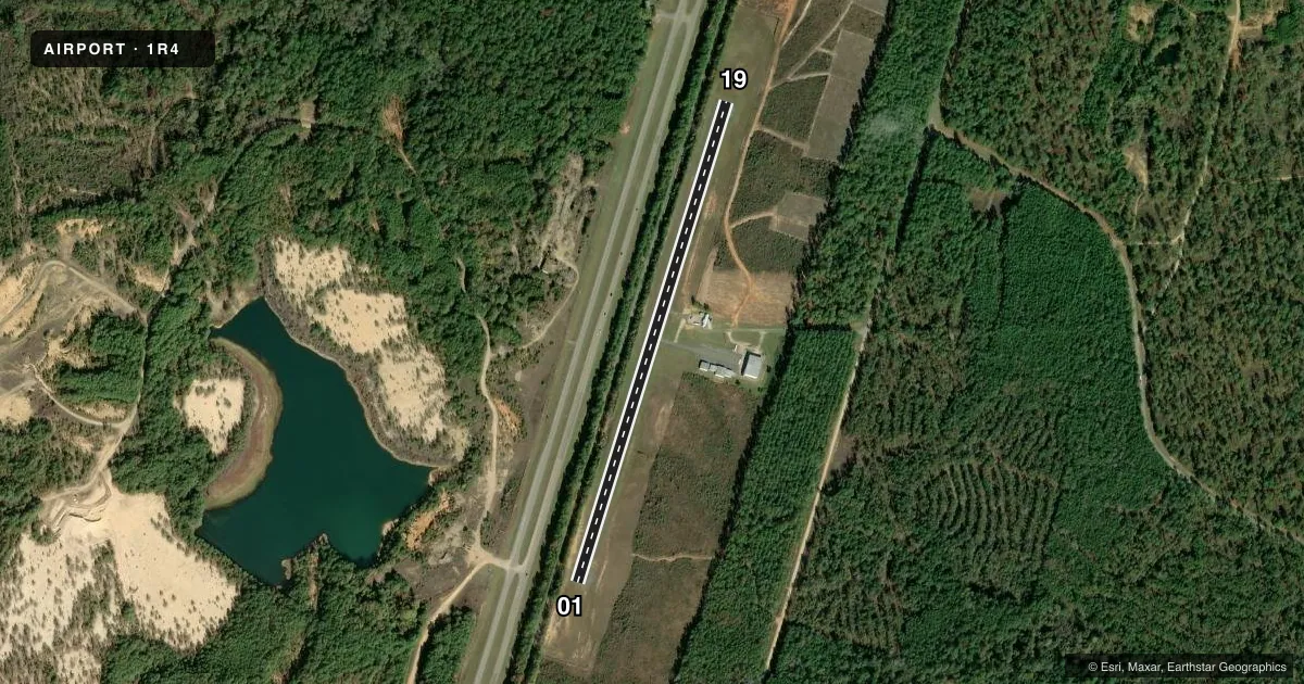
| 01 | — | — | — | — | — | — | 57', trees, 268' from thr, 122' R of cntrln, slope 1 |
| 19 | — | — | — | — | — | — | 63', trees, 628' from thr, 156' R of cntrln, slope 6 |
Declared distances in feet. TORA = takeoff run available, TODA = takeoff distance, ASDA = accelerate-stop, LDA = landing distance.
Airport sketch
Runways drawn to scale from FAA survey coordinates, rendered over satellite imagery. Not for navigation.
Approaches & charts
Services on the field
Fuel grades, oxygen, maintenance, ramp storage and lighting — as declared to the FAA by the airport operator.
Fuel & services
- Fuel
- Not available
- Other services
- AMB
Ramp & ground
- Transient storage
- Tie-down
- Landing fee
- No fee published
- Customs
- Not available
- Lighting schedule
- SEE RMK
- Beacon schedule
- SS-SR
- Beacon
- White / Green (civil land)(WG)
- Wind indicator
- Lighted
- Segmented circle
- No
Fuel & FBOs
Cheapest 100LL and Jet A on the field and nearby. Always confirm with the FBO before taxi.
Airport notes
Surface conditions, obstructions, local procedures, lighting outages and other notes published with each FAA cycle.
General notes
- HELICOPTER TRAFFIC ON FIELD.
- FOR CD CTC MAKS APCH AT 726-780-0456.
- NIGHT OPS NOT RECOMMENDED DUE TO PHYS OBSTN (HIGH TREE LINE ON BOTH ENDS OF RWY) AND LIGHTINGS ISSUES.
- CTC APRT MGR FOR DSGND RAMP SPACE FOR PUB USE.
Lighting notes
- ACTVT MIRL RY 01/19 - 122.8.
Approach & departure obstructions
- 01TREE, 57 FT ABOVE RWY END, 268 FT FROM RWY END, 122 FT LEFT OF CNTRLN, 1:1 SLOPE
Other notes
- MAY PREDATE ACT.
- WINDSOCK LGTS OTS INDEFLY.
- 01/19NUMEROUS 2 INCH CRACKS ON RY.
VFR map & nearby airports
VFR sectional. Tap any ICAO chip to open that airport.
Key facts · 1R4
Answer card- ICAO
- 1R4
- Name
- WOODWORTH
- Location
- WOODWORTH, LOUISIANA
- Elevation
- 140 ft MSL
- Traffic pattern altitude
- 1,140 ft MSL (1,000 AGL)
- Control tower
- Non-towered (use CTAF)
- Total runways
- 1
- Longest runway
- 01/19 · 3,100 ft
- Published ILS approaches
- 0
- Published frequencies
- 1
- Magnetic variation
- 0°
- Current flight rules
- VFR
- Current wind
- 000° at 0 kt
- Favored runway now
- –
Woodworth Airport sits in Woodworth, Louisiana. Field elevation is 140 ft MSL. The airport has one runway. Runway 01/19 is 3,100 ft long and asphalt. There is no control tower. CTAF is 122.9. No ILS approaches are published here.
Pattern altitude is not published. Use the standard 1,000 ft AGL pattern for light piston traffic unless the current Chart Supplement says otherwise. The field has no on-field FBOs listed. Contact the airport operator or the airport manager for ramp space before you go. Helicopter traffic is on the field. Keep your scan active in the pattern and on the ramp.
The published remarks matter here. Night operations are not recommended because of obstructions, a high tree line on both ends and lighting issues. There are also numerous 2 inch cracks on runway 01/19. A tree is reported near the 01 end, 57 ft above the runway end and 122 ft left of centerline. Medium intensity runway lights on 01/19 are activated on 122.8. Windsock lights are on the outside indefinitely. For clearance delivery, contact Maks Approach at 726-780-0456. Check the current Chart Supplement before flying in, especially for any updated operational notes.