METAR & TAF 4R7
4R7 does not publish a METAR.
Showing the nearest reporting station: KOPL (ST LANDRY PARISH) · 17.7 NM away. Conditions at 4R7 may differ.
METAR · KOPL
Observed 09:55Z
KOPL 270955Z AUTO 23003KT 10SM CLR 25/25 A2997 RMK AO2 T02520245
- Wind
- 230° @ 3 kt
- Visibility
- 10 SM
- Temp / Dew
- 25°C / 25°C
- Altimeter
- 29.97 inHg
- Clouds
- CLR
- Density alt
- 1,190 ft
- Ceiling
- Unlimited
- Rules
- VFR
Airport info & contacts
Manager on record, flight service, ARTCC, attendance schedule and pattern altitude — published by the FAA and refreshed every 28 days.
Location
- From city
- 2 NM S
- VFR sectional
- HOUSTON
- ARTCC
- ZHU · HOUSTON
- NOTAM facility
- DRI (NOTAM-D)
Airport manager
- Name
- DAVID KRESWELL
- Phone
- 337-457-6585
- Address
- 252 EUNICE AIRPORT ROAD, EUNICE LA 70535
Flight service · Hours
- FSS DRI
- DE RIDDER1-800-WX-BRIEF
- Attendance
- MON-FRI · 0800-1700
- SAT · ON CALL
- SUN · ON CALL
Frequencies
Tap any row to copy the frequency to your clipboard.
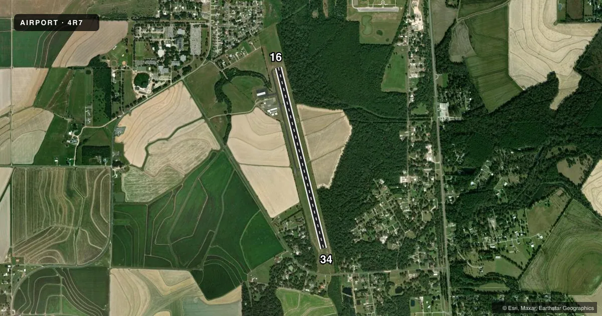
Runways & pattern
Full pagePattern entry · RWY 16
LEFT TRAFFICRunway end performance
| End | TORA | TODA | ASDA | LDA | VGSI | Approach lights | Obstruction |
|---|---|---|---|---|---|---|---|
| 16 | — | — | — | — | PAPI 2-box left(3°) | — | 67', trees, 1304' from thr, 10' R of cntrln, slope 16 |
| 34 | — | — | — | — | PAPI 2-box left(3°) | — | 48', trees, 1179' from thr, 311' R of cntrln, slope 20 |
Declared distances in feet. TORA = takeoff run available, TODA = takeoff distance, ASDA = accelerate-stop, LDA = landing distance.
Airport sketch
Runways drawn to scale from FAA survey coordinates, rendered over satellite imagery. Not for navigation.
Approaches & charts
Services on the field
Fuel grades, oxygen, maintenance, ramp storage and lighting — as declared to the FAA by the airport operator.
Fuel & services
- Fuel
- 100LLA
- Oxygen (bottled)
- Not available
- Oxygen (bulk)
- Not available
- Airframe repair
- Minor
- Power plant repair
- Minor
- Other services
- AGRI,INSTR,RNTL
Ramp & ground
- Transient storage
- Tie-down
- Hangar
- Landing fee
- No fee published
- Customs
- Not available
- Lighting schedule
- SEE RMK
- Beacon schedule
- SS-SR
- Beacon
- White / Green (civil land)(WG)
- Wind indicator
- Lighted
- Segmented circle
- Yes
Fuel & FBOs
Cheapest 100LL and Jet A on the field and nearby. Always confirm with the FBO before taxi.
Airport notes
Surface conditions, obstructions, local procedures, lighting outages and other notes published with each FAA cycle.
General notes
- GCO AVBL ON FREQ 135.075 THRU LAFAYETTE APCH & DRI FSS.
- FOR CD CTC LAFAYETTE APCH AT 337-262-2729, WHEN APCH CLSD CTC HOUSTON ARTCC AT 281-230-5622.
- CTC APRT MGR FOR DSGND RAMP SPACE FOR PUB USE.
Lighting notes
- REIL RWY 16/34 AND MIRL RWY 16/34 PRESET LOW INTST DUSK-DAWN; TO INCR INTST ACTVT - CTAF.
Fuel notes
- 100LLFOR FUEL AFT HRS CALL 337-457-6585.
Approach & departure obstructions
- 16RUNWAY MARKINGS SEVERELY FADED
- 34RUNWAY MARKINGS SEVERELY FADED
- 16RWY 16 PAPI UNUSBL BYD 6 DEGS LEFT OF CNTRLN.
Other notes
- THIS AIRPORT HAS BEEN SURVEYED BY THE NATIONAL GEODETIC SURVEY.
VFR map & nearby airports
VFR sectional. Tap any ICAO chip to open that airport.
Key facts · 4R7
Answer card- ICAO
- 4R7
- Name
- EUNICE
- Location
- EUNICE, LOUISIANA
- Elevation
- 42 ft MSL
- Traffic pattern altitude
- 1,042 ft MSL (1,000 AGL)
- Control tower
- Non-towered (use CTAF)
- Total runways
- 1
- Longest runway
- 16/34 · 5,001 ft
- Published ILS approaches
- 0
- Published frequencies
- 4
- Magnetic variation
- 2°
- Current flight rules
- VFR
- Current wind
- 230° at 3 kt
- Favored runway now
- RWY 16
Eunice Airport (4R7) sits in Eunice, Louisiana. Field elevation is 42 ft MSL. It has one runway, 16/34, which is 5,001 ft long and asphalt. There is no control tower. Pattern altitude is not published, so use the standard 1,000 ft AGL for light piston traffic unless the current Chart Supplement says otherwise.
No ILS approaches are published here. The airport uses CTAF 122.8 and UNICOM 122.8. Lafayette Approach handles approach and departure services on 128.7 and 268.7. Clearance delivery is also handled through Lafayette Approach when it is open. When Approach is closed, contact Houston ARTCC. The field is close enough to the Lafayette area that pilots should be ready for that handoff.
Eunice Flying Service is on the field. It carries AVGAS 100LL and Jet A. For fuel after hours, call the FBO directly. Published remarks also note that runway 16 markings are severely faded. Runway 34 markings are also severely faded. Runway 16 PAPI is unusable beyond 6 degrees left of centerline. REIL and MIRL are preset to low intensity from dusk to dawn. You can increase intensity through CTAF. Ramp space for public use is designated by the airport manager, so call ahead if you need parking.