METAR & TAF 6R1
6R1 does not publish a METAR.
Showing the nearest reporting station: KCWF (CHENNAULT INTL) · 16.3 NM away. Conditions at 6R1 may differ.
METAR · KCWF
Observed 11:00Z
KCWF 271100Z 24007KT 10SM CLR 28/25 A2999
- Wind
- 240° @ 7 kt
- Visibility
- 10 SM
- Temp / Dew
- 28°C / 25°C
- Altimeter
- 29.99 inHg
- Clouds
- CLR
- Density alt
- 1,496 ft
- Ceiling
- Unlimited
- Rules
- VFR
Airport info & contacts
Manager on record, flight service, ARTCC, attendance schedule and pattern altitude — published by the FAA and refreshed every 28 days.
Location
- From city
- 0 NM NW
- VFR sectional
- HOUSTON
- ARTCC
- ZHU · HOUSTON
- NOTAM facility
- DRI (NOTAM-D)
Airport manager
- Name
- KARL ARCENEAUX
- Phone
- 337-570-4590
- Address
- PO BOX 863, WELSH LA 70591
Flight service · Hours
- FSS DRI
- DE RIDDER1-800-WX-BRIEF
- Attendance
- IREG
Frequencies
Tap any row to copy the frequency to your clipboard.
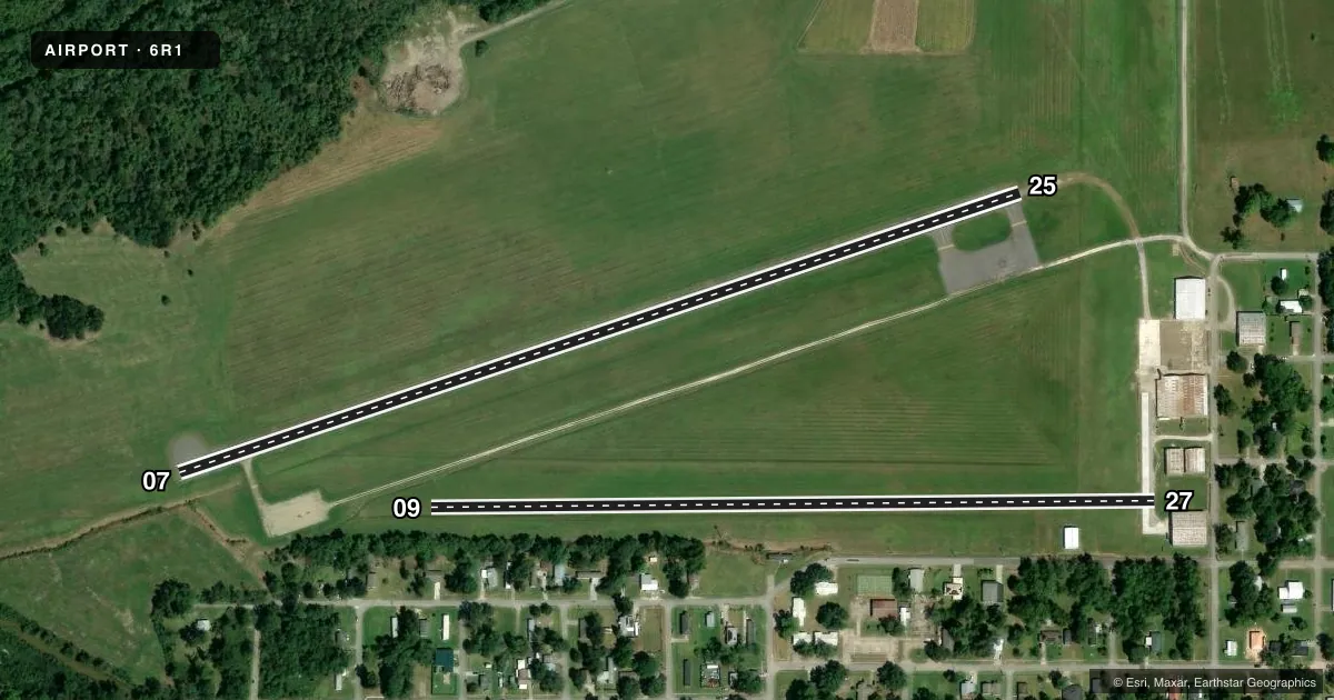
Runways & pattern
Full pagePattern entry · RWY 25
LEFT TRAFFIC| Runway | Heading (°M) | Length | Surface | Traffic |
|---|---|---|---|---|
| 07/25Favored | 65° / 245° | 2,700 ft | ASPH | Standard L |
| 09/27 | 82° / 262° | 2,200 ft | TURF | Standard L |
Runway end performance
| End | TORA | TODA | ASDA | LDA | VGSI | Approach lights | Obstruction |
|---|---|---|---|---|---|---|---|
| 07 | — | — | — | — | — | — | 57', trees, 1137' from thr, 253' R of cntrln, slope 16 |
| 25 | — | — | — | — | — | — | 67', trees, 953' from thr, 131' R of cntrln, slope 11 |
| 09 | — | — | — | — | — | — | 55', trees, 204' from thr, 125' R of cntrln, slope 4 |
| 27 | — | — | — | — | — | — | 51', trees, 367' from thr, 59' R of cntrln, slope 7 |
Declared distances in feet. TORA = takeoff run available, TODA = takeoff distance, ASDA = accelerate-stop, LDA = landing distance.
Airport sketch
Runways drawn to scale from FAA survey coordinates, rendered over satellite imagery. Not for navigation.
Approaches & charts
Services on the field
Fuel grades, oxygen, maintenance, ramp storage and lighting — as declared to the FAA by the airport operator.
Fuel & services
- Fuel
- Not available
- Oxygen (bottled)
- Not available
- Oxygen (bulk)
- Not available
- Airframe repair
- Not available
- Power plant repair
- Not available
- Other services
- AGRI
Ramp & ground
- Transient storage
- Not published
- Landing fee
- No fee published
- Customs
- Not available
- Lighting schedule
- SS-SR
- Beacon schedule
- SS-SR
- Beacon
- White / Green (civil land)(WG)
- Wind indicator
- Lighted
- Segmented circle
- No
Fuel & FBOs
Cheapest 100LL and Jet A on the field and nearby. Always confirm with the FBO before taxi.
Airport notes
Surface conditions, obstructions, local procedures, lighting outages and other notes published with each FAA cycle.
General notes
- TWY FM HGR TO END OF RY 25.
- FOR CD CTC LAKE CHARLES APCH AT 337-480-3103, WHEN APCH CLSD CTC HOUSTON ARTCC AT 281-230-5622.
- CTC APRT MGR FOR DSGND RAMP SPACE FOR PUB USE.
Other notes
- THIS AIRPORT HAS BEEN SURVEYED BY THE NATIONAL GEODETIC SURVEY.
- 07/25RWY HAS SOME SMALL LONGITUDINAL CRACKS WITH GRASS GROWTH. BLOCK CRACKS WITH GRASS GROWTH RWY 07 TURNAROUND. GRAVEL FOD PRESENT IN PLACES.
VFR map & nearby airports
VFR sectional. Tap any ICAO chip to open that airport.
Key facts · 6R1
Answer card- ICAO
- 6R1
- Name
- WELSH
- Location
- WELSH, LOUISIANA
- Elevation
- 18 ft MSL
- Traffic pattern altitude
- 1,018 ft MSL (1,000 AGL)
- Control tower
- Non-towered (use CTAF)
- Total runways
- 2
- Longest runway
- 07/25 · 2,700 ft
- Published ILS approaches
- 0
- Published frequencies
- 4
- Magnetic variation
- 7°
- Current flight rules
- VFR
- Current wind
- 240° at 7 kt
- Favored runway now
- RWY 25
Welsh Airport (6R1) sits in Welsh, Louisiana. Field elevation is 18 ft MSL. The airport has two runways. The longest is runway 07/25 at 2,700 ft. Runway 09/27 is 2,200 ft turf. No control tower is published, so plan for self-announce traffic on CTAF 122.8. No ILS approaches are published here.
Pattern altitude is not published. Use the standard 1,000 ft AGL pattern for light piston operations unless the current FAA Chart Supplement says otherwise. With that standard, traffic would be about 1,018 ft MSL. For clearance delivery, contact Lake Charles Approach at 337-480-3103. If approach is closed, contact Houston ARTCC at 281-230-5622.
There are no on-field FBOs listed. Contact the airport manager for designated ramp space for public use before arrival. Runway 07/25 has reported longitudinal cracking with grass growth. There are block cracks with grass growth at the runway 07 turnaround. Gravel FOD is also reported in places. That makes a careful walkaround and a conservative runway check a good idea before takeoff or landing. A taxiway runs from the hangar to the end of runway 25. The field has been surveyed by the National Geodetic Survey.