METAR & TAF KDRI
Current METAR
Observed 12:55Z
KDRI 271255Z AUTO 26006KT 10SM CLR 26/26 A3001 RMK AO2 T02590259 $
- Wind
- 260° @ 6 kt
- Visibility
- 10 SM
- Temp / Dew
- 26°C / 26°C
- Altimeter
- 30.01 inHg
- Clouds
- CLR
- Density alt
- 1,459 ft
- Ceiling
- Unlimited
- Rules
- VFR
Airport info & contacts
Manager on record, flight service, ARTCC, attendance schedule and pattern altitude — published by the FAA and refreshed every 28 days.
Location
- From city
- 3 NM SW
- VFR sectional
- HOUSTON
- Pattern altitude
- 1,000 ft AGL · 1,202 ft MSL
- ARTCC
- ZHU · HOUSTON
- NOTAM facility
- DRI (NOTAM-D)
Airport manager
- Name
- SAM LACK
- Phone
- 337-463-8250
- Address
- 1220 1ST AVE, DERIDDER LA 70634
Flight service · Hours
- FSS DRI
- DE RIDDER1-800-WX-BRIEF
- Attendance
- MON-FRI · 0800-1700
Frequencies
Tap any row to copy the frequency to your clipboard.
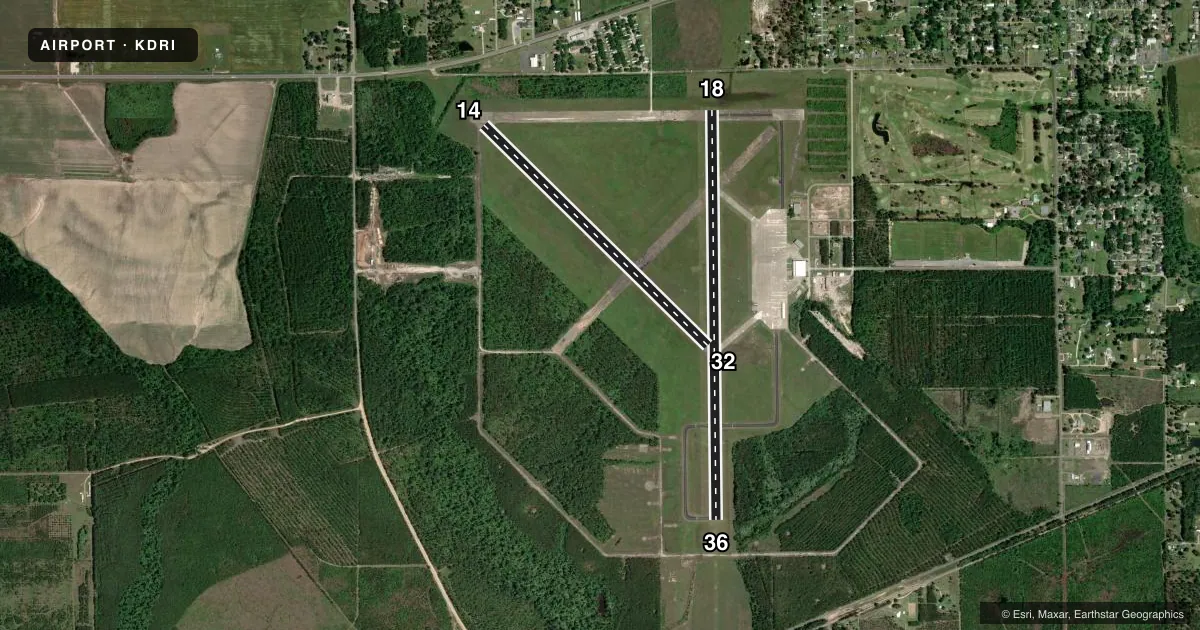
Runways & pattern
Full pagePattern entry · RWY 32
LEFT TRAFFIC| Runway | Heading (°M) | Length | Surface | Traffic |
|---|---|---|---|---|
| 18/36 | 175° / 355° | 5,494 ft | ASPH-CONC | Standard L |
| 14/32Favored | 130° / 310° | 4,218 ft | ASPH | Standard L |
Runway end performance
| End | TORA | TODA | ASDA | LDA | VGSI | Approach lights | Obstruction |
|---|---|---|---|---|---|---|---|
| 18 | — | — | — | — | PAPI 4-box right(3°) | — | 95', trees, 2437' from thr, 0' R of cntrln, slope 23 |
| 36 | — | — | — | — | PAPI 4-box left(3°) | ODALS | 74', trees, 2169' from thr, 226' R of cntrln, slope 26 |
| 14 | — | — | — | — | — | — | 81', trees, 1426' from thr, 163' R of cntrln, slope 15 |
| 32 | — | — | — | — | — | — | 65', trees, 1635' from thr, 114' R of cntrln, slope 22 |
Declared distances in feet. TORA = takeoff run available, TODA = takeoff distance, ASDA = accelerate-stop, LDA = landing distance.
Airport sketch
Runways drawn to scale from FAA survey coordinates, rendered over satellite imagery. Not for navigation.
Approaches & charts
Services on the field
Fuel grades, oxygen, maintenance, ramp storage and lighting — as declared to the FAA by the airport operator.
Fuel & services
- Fuel
- 100LLA
- Oxygen (bottled)
- Not available
- Oxygen (bulk)
- Not available
- Airframe repair
- Minor
- Power plant repair
- Minor
- Other services
- AGRI,INSTR,PAJA,RNTL
Ramp & ground
- Transient storage
- Tie-down
- Hangar
- Landing fee
- No fee published
- Customs
- Not available
- Lighting schedule
- SEE RMK
- Beacon schedule
- SS-SR
- Beacon
- White / Green (civil land)(WG)
- Wind indicator
- Lighted
- Segmented circle
- No
Fuel & FBOs
Cheapest 100LL and Jet A on the field and nearby. Always confirm with the FBO before taxi.
Airport notes
Surface conditions, obstructions, local procedures, lighting outages and other notes published with each FAA cycle.
General notes
- FOR CD IF UNA TO CTC ON FSS FREQ, CTC MAKS APCH AT 726-780-0456.
- CTC APRT MGR FOR DSGND RAMP SPACE FOR PUB USE.
- COMMUNICATIONS: MAKS APP VOIP 726-780-0456
Lighting notes
- REIL RWY 18 AND MIRL RWY 18/36 PRESET LOW INTST DUSK-DAWN; TO INCR INTST ACTVT - CTAF.
Fuel notes
- 100LL100LL AVBL 24 HRS SELF SERVICE WITH CREDIT CARD. FOR JET A AFT HRS & HOLS CALL 337-401-2967.
Approach & departure obstructions
- 18RUNWAY 18 MARKINGS FADED
- 36RUNWAY 36 MARKINGS FADED
- 14APCH SLP 20:1 TO DSPLCD THR.
Other notes
- 1FOR ATTENDANT OTHER TIMES CALL 337-401-2967.
VFR map & nearby airports
VFR sectional. Tap any ICAO chip to open that airport.
Key facts · KDRI
Answer card- ICAO
- KDRI
- Name
- BEAUREGARD RGNL
- Location
- DE RIDDER, LOUISIANA
- Elevation
- 201.8 ft MSL
- Traffic pattern altitude
- 1,201.8 ft MSL (1,000 AGL)
- Control tower
- Non-towered (use CTAF)
- Total runways
- 2
- Longest runway
- 18/36 · 5,494 ft
- Published ILS approaches
- 0
- Published frequencies
- 4
- Magnetic variation
- 4°
- Current flight rules
- VFR
- Current wind
- 260° at 6 kt
- Favored runway now
- RWY 32
Beauregard RGNL sits in De Ridder, Louisiana. Field elevation is 201.8 ft MSL. The airport has two runways. The longest is 5,494 ft. Runway 18/36 is asphalt-concrete. Runway 14/32 is asphalt. There is no control tower. Pattern altitude is 1,000 ft AGL, which is 1,201.8 ft MSL.
No ILS approaches are published here, so plan with the current approach data before you go. The field uses CTAF 122.8 and UNICOM 122.8. If you need clearance delivery and cannot reach FSS, the published remark points pilots to MAKS Approach. The airport also lists MAKS Approach VOIP on the field data. That matters if you are arriving IFR or need help coordinating.
Beauregard Regional Airport is the on-field FBO. It carries 100LL, Jet A and Jet A Prist. 100LL is available 24 hours self-serve with credit card. For Jet A after hours or on holidays, call ahead. Published remarks also note runway 18 markings are faded. Runway 36 markings are faded too. The approach slope is 20 to 1 to the displaced threshold. Brief that on final. Contact the airport manager for designated ramp space for public use.