METAR & TAF KMCB
Current METAR
Observed 22:53Z
KMCB 262253Z AUTO 24007KT 10SM FEW060 FEW080 34/21 A2998 RMK AO2 SLP144 T03440211
- Wind
- 240° @ 7 kt
- Visibility
- 10 SM
- Temp / Dew
- 34°C / 21°C
- Altimeter
- 29.98 inHg
- Clouds
- FEW
- Density alt
- 2,718 ft
- Ceiling
- Unlimited
- Rules
- VFR
Airport info & contacts
Manager on record, flight service, ARTCC, attendance schedule and pattern altitude — published by the FAA and refreshed every 28 days.
Location
- From city
- 4 NM S
- VFR sectional
- NEW ORLEANS
- ARTCC
- ZHU · HOUSTON
- NOTAM facility
- MCB (NOTAM-D)
Airport manager
- Name
- ADAM LOFTON
- Phone
- 601-684-8950
- Address
- 2051 JOHN E. LEWIS DR, MCCOMB MS 39648
Flight service · Hours
- FSS GWO
- GREENWOOD1-800-WX-BRIEF
- Attendance
- 0730-1730
Frequencies
Tap any row to copy the frequency to your clipboard.
Runways & pattern
Full pagePattern entry · RWY 16
LEFT TRAFFICRunway end performance
| End | TORA | TODA | ASDA | LDA | VGSI | Approach lights | Obstruction |
|---|---|---|---|---|---|---|---|
| 16 | — | — | — | — | PAPI 4-box left(3°) | MALSF | — |
| 34 | — | — | — | — | PAPI 2-box left(3°) | — | — |
Declared distances in feet. TORA = takeoff run available, TODA = takeoff distance, ASDA = accelerate-stop, LDA = landing distance.
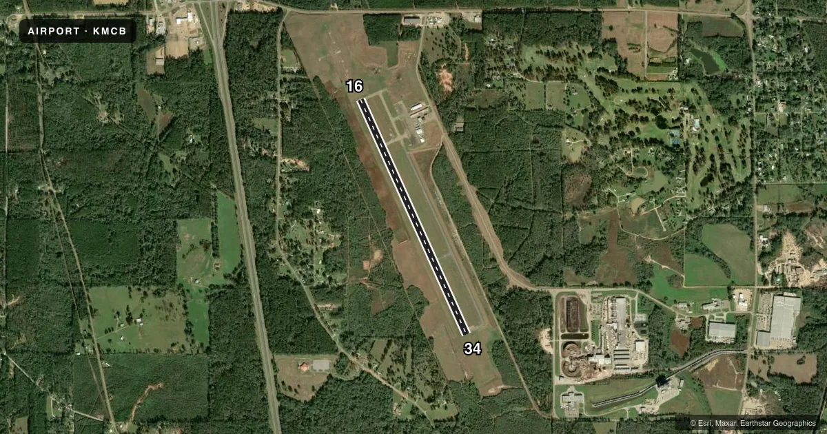
Airport sketch
Runways drawn to scale from FAA survey coordinates, rendered over satellite imagery. Not for navigation.
Approaches & charts
ILS · 1
Services on the field
Fuel grades, oxygen, maintenance, ramp storage and lighting — as declared to the FAA by the airport operator.
Fuel & services
- Fuel
- 100LLA1+
- Oxygen (bottled)
- Not available
- Oxygen (bulk)
- Not available
- Airframe repair
- Minor
- Power plant repair
- Minor
Ramp & ground
- Transient storage
- Tie-down
- Hangar
- Landing fee
- No fee published
- Customs
- Not available
- Lighting schedule
- SEE RMK
- Beacon schedule
- SS-SR
- Beacon
- White / Green (civil land)(WG)
- Wind indicator
- Lighted
- Segmented circle
- Yes
Fuel & FBOs
Cheapest 100LL and Jet A on the field and nearby. Always confirm with the FBO before taxi.
Airport notes
Surface conditions, obstructions, local procedures, lighting outages and other notes published with each FAA cycle.
General notes
- COURTESY CAR AVBL.
- FOR CD IF UNA TO CTC ON FSS FREQ, CTC HOUSTON ARTCC AT 281-230-5622.
Lighting notes
- ACTVT MALSF RWY 16 - CTAF. MIRL RWY 16/34 PRESET LOW INTST DUSK-0000, AFT 0000 INCR INTST - CTAF.
Fuel notes
- 100LLFOR ATTENDANT & FUEL AFT HRS CALL 601-684-8950.
Approach & departure obstructions
- 16MARKINGS FADED.
- 34MARKINGS FADED.
Other notes
- THIS AIRPORT HAS BEEN SURVEYED BY THE NATIONAL GEODETIC SURVEY.
- PILOTS MUST PRVD THEIR OWN TIEDOWN ROPES.
VFR map & nearby airports
VFR sectional. Tap any ICAO chip to open that airport.
Key facts · KMCB
Answer card- ICAO
- KMCB
- Name
- MC COMB/PIKE COUNTY/JOHN E LEWIS FLD
- Location
- MC COMB, MISSISSIPPI
- Elevation
- 413.2 ft MSL
- Traffic pattern altitude
- 1,413.2 ft MSL (1,000 AGL)
- Control tower
- Non-towered (use CTAF)
- Total runways
- 1
- Longest runway
- 16/34 · 5,000 ft
- Published ILS approaches
- 1
- Published frequencies
- 2
- Magnetic variation
- 1°
- Current flight rules
- VFR
- Current wind
- 240° at 7 kt
- Favored runway now
- RWY 16
MC Comb/Pike County/John E Lewis Fld sits in McComb, Mississippi. Field elevation is 413.2 ft MSL. The airport has one runway, 16/34, at 5,000 ft asphalt. There is no control tower. CTAF and UNICOM are both 123.05.
Runway 16 has one ILS approach. The published pattern altitude is not listed, so use the standard 1,000 ft AGL pattern unless ATC or the current Chart Supplement says otherwise. The field has MALSR lighting for runway 16. It is activated by CTAF. Medium intensity runway lights on 16 and 34 are preset low from dusk to midnight. They increase after midnight, also controlled by CTAF.
Air Services of Mississippi is on the field. It carries 100LL and Jet A. Call (601) 684-8950 for fuel or after-hours service. The airport also has a courtesy car. Pilots should bring their own tiedown ropes. Runway markings on both ends are faded, so plan for a careful look on rollout and taxi. If you need clearance delivery and cannot reach Flight Service, Houston ARTCC is listed at 281-230-5622. This is an uncontrolled field, so monitor CTAF closely and confirm runway lighting activation before night operations.