METAR & TAF 0R0
Current METAR
Observed 23:15Z
K0R0 132315Z AUTO 23007KT 10SM CLR 34/25 A2997 RMK AO2
- Wind
- 230° @ 7 kt
- Visibility
- 10 SM
- Temp / Dew
- 34°C / 25°C
- Altimeter
- 29.97 inHg
- Clouds
- CLR
- Density alt
- 2,553 ft
- Ceiling
- Unlimited
- Rules
- VFR
Airport info & contacts
Manager on record, flight service, ARTCC, attendance schedule and pattern altitude — published by the FAA and refreshed every 28 days.
Location
- From city
- 3 NM N
- VFR sectional
- NEW ORLEANS
- ARTCC
- ZHU · HOUSTON
- NOTAM facility
- GWO (NOTAM-D)
Airport manager
- Name
- DAVID DECLEMENT
- Phone
- 601-736-9295
- Address
- 151 AIRPORT RD, COLUMBIA MS 39429
Flight service · Hours
- FSS GWO
- GREENWOOD1-800-WX-BRIEF
- Attendance
- ON CALL
Frequencies
Tap any row to copy the frequency to your clipboard.
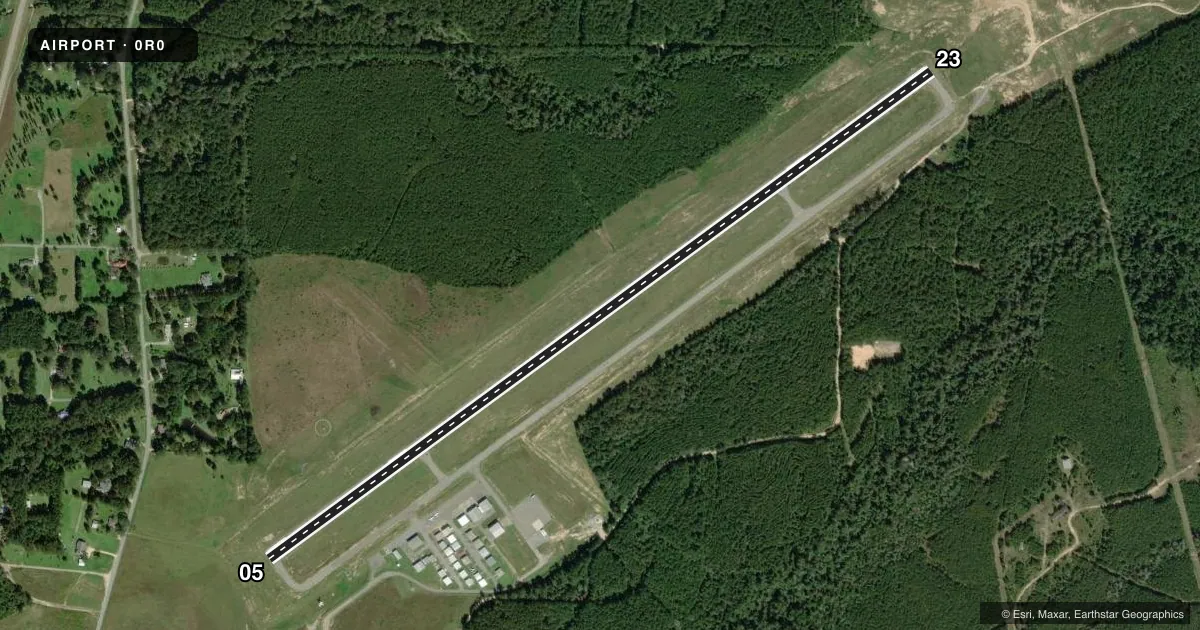
Runways & pattern
Full pagePattern entry · RWY 23
LEFT TRAFFICRunway end performance
| End | TORA | TODA | ASDA | LDA | VGSI | Approach lights | Obstruction |
|---|---|---|---|---|---|---|---|
| 05 | — | — | — | — | PAPI 4-box left(3°) | — | 55', trees, 2000' from thr, slope 32 |
| 23 | — | — | — | — | PAPI 4-box left(3°) | — | 26', tree, 1060' from thr, 50' R of cntrln, slope 33 |
Declared distances in feet. TORA = takeoff run available, TODA = takeoff distance, ASDA = accelerate-stop, LDA = landing distance.
Airport sketch
Runways drawn to scale from FAA survey coordinates, rendered over satellite imagery. Not for navigation.
Approaches & charts
Services on the field
Fuel grades, oxygen, maintenance, ramp storage and lighting — as declared to the FAA by the airport operator.
Fuel & services
- Fuel
- 100LLA
- Oxygen (bottled)
- Not available
- Oxygen (bulk)
- Not available
- Airframe repair
- Minor
- Power plant repair
- Minor
- Other services
- AVNCS,INSTR
Ramp & ground
- Transient storage
- Tie-down
- Hangar
- Landing fee
- No fee published
- Customs
- Not available
- Lighting schedule
- SEE RMK
- Beacon schedule
- SS-SR
- Beacon
- White / Green (civil land)(WG)
- Wind indicator
- Lighted
- Segmented circle
- Yes
Fuel & FBOs
Cheapest 100LL and Jet A on the field and nearby. Always confirm with the FBO before taxi.
Airport notes
Surface conditions, obstructions, local procedures, lighting outages and other notes published with each FAA cycle.
General notes
- PUB FONE AVBL 601-736-9295.
- FOR CD CTC HOUSTON ARTCC AT 281-230-5622.
Lighting notes
- ACTVT REIL RWY 05 & 23; MIRL RWY 5/23 - CTAF. PAPI RWY 05 & 23 OPR CONSLY.
Fuel notes
- 100LLFUEL SVC AVBL 24 HRS WITH CREDIT CARD.
Other notes
- 3FOR SVC CALL 601-441-0299 OR 601-441-1867.
- INSTRINSTR AVBL 601-606-8692.
VFR map & nearby airports
VFR sectional. Tap any ICAO chip to open that airport.
Key facts · 0R0
Answer card- ICAO
- 0R0
- Name
- COLUMBIA/MARION COUNTY
- Location
- COLUMBIA, MISSISSIPPI
- Elevation
- 270.2 ft MSL
- Traffic pattern altitude
- 1,270.2 ft MSL (1,000 AGL)
- Control tower
- Non-towered (use CTAF)
- Total runways
- 1
- Longest runway
- 05/23 · 5,500 ft
- Published ILS approaches
- 0
- Published frequencies
- 2
- Magnetic variation
- 0°
- Current flight rules
- VFR
- Current wind
- 230° at 7 kt
- Favored runway now
- RWY 23
Columbia/Marion County Airport sits in Columbia, Mississippi. Field elevation is 270.2 ft MSL. The airport has one runway. Runway 05/23 is 5,500 ft long on asphalt. There is no control tower. CTAF and UNICOM are both 122.8. No ILS approaches are published here. Plan with the current chart and your own approach setup.
Pattern altitude is not published. Use the standard 1,000 ft AGL pattern unless local procedures or the current Chart Supplement say otherwise. The on-field FBO is Columbia-Marion County Airport. It carries AVGAS 100LL and Jet A with Prist. Fuel service is available 24 hours with credit card. Runway end identifier lights are active on 05 and 23. Medium intensity runway lights are pilot-controlled on CTAF. PAPI is available on both ends and operates continuously.
This is a non-towered field. Expect self-announce traffic and normal see-and-avoid work. The published remarks also list phone numbers for instrument services, fuel service and clearance delivery through Houston ARTCC. If you need current operating details, call the airport operator or the FBO directly before departure.