METAR & TAF M80
M80 does not publish a METAR.
Showing the nearest reporting station: KTVR (VICKSBURG TALLULAH RGNL) · 7.3 NM away. Conditions at M80 may differ.
METAR · KTVR
Observed 05:53Z
KTVR 270553Z AUTO 00000KT 10SM CLR 25/24 A2997 RMK AO2 SLP153 T02500244 10317 20250 403500233 50005
- Wind
- 000° @ 0 kt
- Visibility
- 10 SM
- Temp / Dew
- 25°C / 24°C
- Altimeter
- 29.97 inHg
- Clouds
- CLR
- Density alt
- 1,244 ft
- Ceiling
- Unlimited
- Rules
- VFR
Airport info & contacts
Manager on record, flight service, ARTCC, attendance schedule and pattern altitude — published by the FAA and refreshed every 28 days.
Location
- From city
- 2 NM E
- VFR sectional
- MEMPHIS
- ARTCC
- ZME · MEMPHIS
- NOTAM facility
- DRI (NOTAM-D)
Airport manager
- Name
- STEVE GUSTAFSON
- Phone
- 318-282-7462
- Address
- 251 HANNAH PLANTATION RD, TALLULAH LA 71282
Flight service · Hours
- FSS DRI
- DE RIDDER1-800-WX-BRIEF
- Attendance
- ON CALL
Frequencies
Tap any row to copy the frequency to your clipboard.
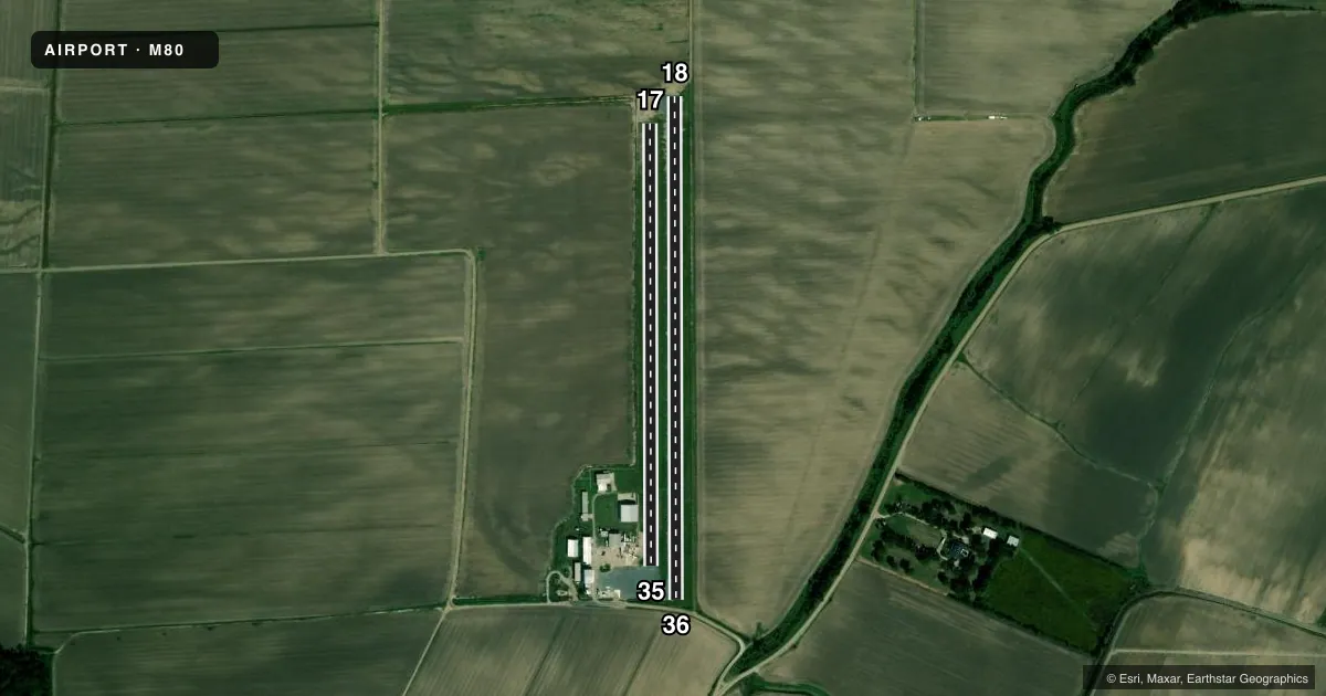
Runways & pattern
Full pagePattern entry · RWY 18
LEFT TRAFFIC| Runway | Heading (°M) | Length | Surface | Traffic |
|---|---|---|---|---|
| 18/36 | 177° / 357° | 3,003 ft | ASPH | Standard L |
| 17/35 | 177° / 357° | 2,642 ft | TURF | Standard L |
Runway end performance
| End | TORA | TODA | ASDA | LDA | VGSI | Approach lights | Obstruction |
|---|---|---|---|---|---|---|---|
| 35 | — | — | — | — | — | — | 15', acft, 200' from thr, 0' R of cntrln, slope 13 |
Declared distances in feet. TORA = takeoff run available, TODA = takeoff distance, ASDA = accelerate-stop, LDA = landing distance.
Airport sketch
Runways drawn to scale from FAA survey coordinates, rendered over satellite imagery. Not for navigation.
Approaches & charts
Services on the field
Fuel grades, oxygen, maintenance, ramp storage and lighting — as declared to the FAA by the airport operator.
Fuel & services
- Fuel
- Not available
- Oxygen (bottled)
- Not available
- Oxygen (bulk)
- Not available
- Airframe repair
- Not available
- Power plant repair
- Not available
- Other services
- AGRI,INSTR
Ramp & ground
- Transient storage
- Tie-down
- Landing fee
- No fee published
- Customs
- Not available
- Lighting schedule
- SEE RMK
- Beacon schedule
- SS-SR
- Beacon
- White / Green (civil land)(WG)
- Wind indicator
- Yes
- Segmented circle
- No
Fuel & FBOs
Cheapest 100LL and Jet A on the field and nearby. Always confirm with the FBO before taxi.
Airport notes
Surface conditions, obstructions, local procedures, lighting outages and other notes published with each FAA cycle.
General notes
- AEROBATIC BOX ON FIELD - CHECK NOTAMS.
- NUMEROUS AGRI & ULTRALIGHT OPNS AT ARPT.
- FOR CD CTC MEMPHIS ARTCC AT 901-368-8453/8449.
- CTC APRT MGR FOR DSGND RAMP SPACE FOR PUB USE.
Lighting notes
- ARPT BCN OTS.
- ACTVT MIRL RWY 18/36 - CTAF
Approach & departure obstructions
- 36+15 FT ROAD 50 FT FM END OF RWY.
- 36THLD DSPLCD DALGT OPNS ONLY.
- 36APCH SLOPE 20:1 TO DSPLCD THLD.
- 35AIRCRAFT PARKING APRON 200 FEET SOUTH OF RWY 35 THLD
Other notes
- WIND INDICATOR LIGHT OTS INDEFLY.
- 1FOR ATTENDANT CALL 318-282-7462.
VFR map & nearby airports
VFR sectional. Tap any ICAO chip to open that airport.
Key facts · M80
Answer card- ICAO
- M80
- Name
- SCOTT
- Location
- TALLULAH, LOUISIANA
- Elevation
- 85.8 ft MSL
- Traffic pattern altitude
- 1,085.8 ft MSL (1,000 AGL)
- Control tower
- Non-towered (use CTAF)
- Total runways
- 2
- Longest runway
- 18/36 · 3,003 ft
- Published ILS approaches
- 0
- Published frequencies
- 2
- Magnetic variation
- 3°
- Current flight rules
- VFR
- Current wind
- 000° at 0 kt
- Favored runway now
- –
Scott Airport is in Tallulah, Louisiana. Field elevation is 85.8 ft MSL. The airport has two runways. The longest is runway 18/36 at 3,003 ft asphalt. Runway 17/35 is 2,642 ft turf. There is no control tower. CTAF and UNICOM are both 122.8. No ILS approaches are published, so plan with that in mind before you launch.
Pattern altitude is not published. Use the standard 1,000 ft AGL pattern unless the current Chart Supplement or local procedures say otherwise. The airport sees numerous agricultural and ultralight operations. That makes a good CTAF listen-in important before you join the pattern. Medium intensity runway lights are on runway 18/36. They are activated by CTAF. Day lighting is available only on runway 36. The runway 36 threshold is displaced. There is also a 15-foot road 50 feet from the end of runway 36. The airport beacon is out of service. The wind indicator light is also out of service indefinitely.
No on-field FBOs are listed. Contact the airport operator or the FBO directly by phone for current ramp space and service details. For clearance delivery, Memphis ARTCC is listed in the remarks. Check NOTAMs before arrival. There is also an aerobatic box on the field.