METAR & TAF KTVR
Current METAR
Observed 02:53Z
KTVR 270253Z AUTO 00000KT 10SM CLR 26/25 A2995 RMK AO2 SLP148 T02610250 53002
- Wind
- 000° @ 0 kt
- Visibility
- 10 SM
- Temp / Dew
- 26°C / 25°C
- Altimeter
- 29.95 inHg
- Clouds
- CLR
- Density alt
- 1,389 ft
- Ceiling
- Unlimited
- Rules
- VFR
Airport info & contacts
Manager on record, flight service, ARTCC, attendance schedule and pattern altitude — published by the FAA and refreshed every 28 days.
Location
- From city
- 9 NM E
- VFR sectional
- MEMPHIS
- Pattern altitude
- 1,000 ft AGL · 1,086 ft MSL
- ARTCC
- ZME · MEMPHIS
- NOTAM facility
- TVR (NOTAM-D)
Airport manager
- Name
- RANDY WOODS
- Phone
- 318-574-5841
- Address
- 175 VTR AIRPORT RD., TALLULAH LA 71282
Flight service · Hours
- FSS DRI
- DE RIDDER1-800-WX-BRIEF
- Attendance
- 0700-1730
- HOLIDAYS · 1000-1600
Frequencies
Tap any row to copy the frequency to your clipboard.
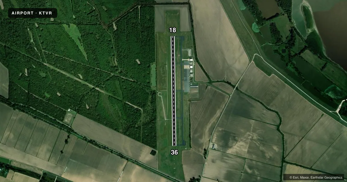
Runways & pattern
Full pagePattern entry · RWY 18
LEFT TRAFFICRunway end performance
| End | TORA | TODA | ASDA | LDA | VGSI | Approach lights | Obstruction |
|---|---|---|---|---|---|---|---|
| 18 | 5,002' | 5,002' | 5,002' | 5,002' | PAPI 4-box left(3°) | — | 91', trees, 2472' from thr, 134' R of cntrln, slope 24 |
| 36 | 5,002' | 5,002' | 5,002' | 5,002' | PAPI 4-box left(3°) | SSALR | 64', trees, 2285' from thr, 375' R of cntrln, slope 32 |
Declared distances in feet. TORA = takeoff run available, TODA = takeoff distance, ASDA = accelerate-stop, LDA = landing distance.
Airport sketch
Runways drawn to scale from FAA survey coordinates, rendered over satellite imagery. Not for navigation.
Approaches & charts
ILS · 1
Services on the field
Fuel grades, oxygen, maintenance, ramp storage and lighting — as declared to the FAA by the airport operator.
Fuel & services
- Fuel
- 100LLA
- Airframe repair
- Major
- Power plant repair
- Major
Ramp & ground
- Transient storage
- Tie-down
- Lighting schedule
- SEE RMK
- Beacon schedule
- SS-SR
- Beacon
- White / Green (civil land)(WG)
- Wind indicator
- Lighted
- Segmented circle
- Yes
Fuel & FBOs
Cheapest 100LL and Jet A on the field and nearby. Always confirm with the FBO before taxi.
Airport notes
Surface conditions, obstructions, local procedures, lighting outages and other notes published with each FAA cycle.
General notes
- CROP DUSTING ACTIVITY 2 NM RADIUS OF ARPT.
- PILOTS IN TFC PATTERN ARE REQUESTED TO AVOID OVER FLIGHT OF MOUND LA 1/2 MI SOUTH & EAST OF RY 36.
- MIGRATORY BIRDS INVOF ARPT.
- FOR CD CTC MEMPHIS ARTCC AT 901-368-8453/8449.
- CTC APRT MGR FOR DSGND RAMP SPACE FOR PUB USE.
Lighting notes
- MIRL RWY 18/36 ,REIL RWY 18, SSALR RWY 36 PRESET LOW INTST DUSK TO DAWN; TO INCR INTST ACTVT - CTAF.
Other notes
- SEE PROJECT FILE ON ARPT IN ASW REGION.
- DSTC & DRCTN TO ARPT FM VICKSBURG MS - 07 NM WEST.
- 1FOR ARPT MGR AFT HRS CALL 318-366-1615.
- OWNERAIRPORT BOARD.
VFR map & nearby airports
VFR sectional. Tap any ICAO chip to open that airport.
Key facts · KTVR
Answer card- ICAO
- KTVR
- Name
- VICKSBURG TALLULAH RGNL
- Location
- TALLULAH, LOUISIANA
- Elevation
- 85.7 ft MSL
- Traffic pattern altitude
- 1,085.7 ft MSL (1,000 AGL)
- Control tower
- Non-towered (use CTAF)
- Total runways
- 1
- Longest runway
- 18/36 · 5,002 ft
- Published ILS approaches
- 1
- Published frequencies
- 2
- Magnetic variation
- 2°
- Current flight rules
- VFR
- Current wind
- 000° at 0 kt
- Favored runway now
- –
Vicksburg Tallulah Regional Airport (KTVR) sits in Tallulah, Louisiana. Field elevation is 85.7 ft MSL. The airport has one runway. Runway 18/36 is 5,002 ft of asphalt, with magnetic headings of 179° and 359°. There is no control tower. CTAF and UNICOM are both 123.0. Pattern altitude is 1,000 ft AGL, which is 1,085.7 ft MSL.
An ILS is published for runway 36. The on-field FBO is Vicksburg Tallulah Regional Airport. It carries 100LL, Jet A and Jet A Prist. Call (318) 574-5841 for current service details before you go. Published remarks also note medium intensity runway lights on 18/36. Runway end identifier lights are on runway 18. Runway 36 has steady burning approach lights with runway alignment indicator lights. Those lights are preset to low intensity from dusk to dawn. Use the CTAF to increase intensity.
First-time pilots should plan for bird activity in the area. Crop dusting also occurs within 2 NM of the airport. Pilots in the pattern are asked to avoid overflight of Mound Lake, which sits about one half mile south and east of runway 36. For clearance delivery, contact Memphis ARTCC. If you need ramp space for public use, contact the airport manager first. The airport is owned by the Airport Board.