METAR & TAF 15A
15A does not publish a METAR.
Showing the nearest reporting station: KBFM (MOBILE INTL) · 17.4 NM away. Conditions at 15A may differ.
METAR · KBFM
Observed 12:53Z
KBFM 271253Z 30008KT 10SM BKN110 29/24 A2999 RMK AO2 SLP155 T02890244
- Wind
- 300° @ 8 kt
- Visibility
- 10 SM
- Temp / Dew
- 29°C / 24°C
- Altimeter
- 29.99 inHg
- Clouds
- BKN
- Density alt
- 1,603 ft
- Ceiling
- 11,000 ft AGL
- Rules
- VFR
Airport info & contacts
Manager on record, flight service, ARTCC, attendance schedule and pattern altitude — published by the FAA and refreshed every 28 days.
Location
- From city
- 3 NM NE
- VFR sectional
- NEW ORLEANS
- ARTCC
- ZHU · HOUSTON
- NOTAM facility
- ANB (NOTAM-D)
Airport manager
- Name
- LOUIS G. BUFFKIN
- Phone
- 251-689-9263
- Address
- 1931 DEADLAKE MARINA RD., CREOLA AL 36525
Flight service · Hours
- FSS ANB
- ANNISTON1-800-WX-BRIEF
- Attendance
- Unattended
Frequencies
Tap any row to copy the frequency to your clipboard.
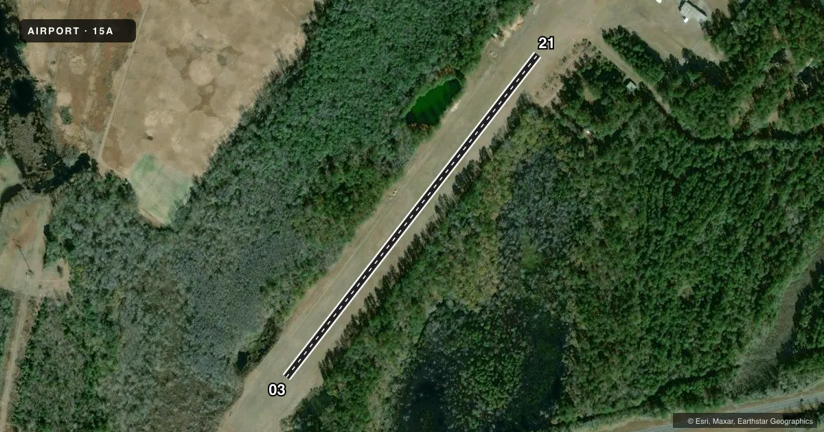
Runways & pattern
Full pagePattern entry · RWY 21
LEFT TRAFFICAirport sketch
Runways drawn to scale from FAA survey coordinates, rendered over satellite imagery. Not for navigation.
Approaches & charts
Services on the field
Fuel grades, oxygen, maintenance, ramp storage and lighting — as declared to the FAA by the airport operator.
Fuel & services
- Fuel
- Not available
- Other services
- AGRI
Ramp & ground
- Transient storage
- Tie-down
- Landing fee
- No fee published
- Lighting schedule
- SEE RMK
- Beacon schedule
- SEE RMK
- Beacon
- White / Green (civil land)(WG)
- Wind indicator
- Yes
- Segmented circle
- No
Fuel & FBOs
Cheapest 100LL and Jet A on the field and nearby. Always confirm with the FBO before taxi.
Airport notes
Surface conditions, obstructions, local procedures, lighting outages and other notes published with each FAA cycle.
General notes
- FOR CD CTC MOBILE APCH AT 251-662-6236, WHEN APCH CLSD CTC HOUSTON ARTCC AT 281-230-5622.
Lighting notes
- OTS INDEFLY.
- NO BCN LGT - DAY OPNS ONLY.
- NO RWY LGTS - DAY OPNS ONLY.
Runway surface & condition
- 03/21RWY 03/21 NSTD LIRL; NO THR LGTS, OTS INDEFLY.
Approach & departure obstructions
- 03RWY EDGE/THLD MKD BY FRANGIBLE PVC PIPES
- 21RWY EDGE/THLD MKD BY FRANGIBLE PVC PIPES
Other notes
- VFR USE ONLY.
- MANAGERADDL PHONE 251-689-9263
VFR map & nearby airports
VFR sectional. Tap any ICAO chip to open that airport.
Key facts · 15A
Answer card- ICAO
- 15A
- Name
- MARK REYNOLDS/NORTH MOBILE COUNTY
- Location
- CREOLA, ALABAMA
- Elevation
- 8 ft MSL
- Traffic pattern altitude
- 1,008 ft MSL (1,000 AGL)
- Control tower
- Non-towered (use CTAF)
- Total runways
- 1
- Longest runway
- 03/21 · 2,000 ft
- Published ILS approaches
- 0
- Published frequencies
- 2
- Magnetic variation
- 1°
- Current flight rules
- VFR
- Current wind
- 300° at 8 kt
- Favored runway now
- RWY 21
Mark Reynolds/North Mobile County Airport is in Creola, Alabama. Field elevation is 8 ft MSL. The airport has one runway. Runway 03/21 is 2,000 ft of turf, which makes this a short-field stop for light aircraft. No ILS approaches are published. Pattern altitude is not published, so use the standard 1,000 ft AGL unless the current Chart Supplement says otherwise.
This field is not towered. CTAF and UNICOM are both 122.8. Published remarks say the airport is for VFR use only. Daytime operations only apply here. There are no runway lights and no beacon lights. That matters if you are planning a late arrival. The runway edge and threshold are marked with frangible PVC pipes. Runway 03/21 also has nonstandard low intensity runway lights. The field is still listed as out of service indefinitely.
No on-field FBOs are listed. Plan on coordinating directly with the airport operator before you go. For clearance delivery, contact Mobile Approach at 251-662-6236. If approach is closed, use Houston ARTCC at 281-230-5622. The airport manager number listed in the remarks is 251-689-9263. With a turf runway, short length and no published instrument approach, this is a good field to treat as a fair-weather VFR stop only.