METAR & TAF KCQF
Current METAR
Observed 16:35Z
KCQF 271635Z AUTO 32006KT 10SM OVC075 31/23 A2997 RMK AO2
- Wind
- 320° @ 6 kt
- Visibility
- 10 SM
- Temp / Dew
- 31°C / 23°C
- Altimeter
- 29.97 inHg
- Clouds
- OVC
- Density alt
- 1,971 ft
- Ceiling
- 7,500 ft AGL
- Rules
- VFR
Airport info & contacts
Manager on record, flight service, ARTCC, attendance schedule and pattern altitude — published by the FAA and refreshed every 28 days.
Location
- From city
- 3 NM SE
- VFR sectional
- NEW ORLEANS
- ARTCC
- ZHU · HOUSTON
- NOTAM facility
- ANB (NOTAM-D)
Airport manager
- Name
- DAVE FRIEDEL
- Phone
- 251-383-8515
- Address
- 8600 COUNTY RD 32, FAIRHOPE AL 36532
Flight service · Hours
- FSS ANB
- ANNISTON1-800-WX-BRIEF
- Attendance
- APR-OCT · 0700-2000
- NOV-MAR · 0700-1900
Frequencies
Tap any row to copy the frequency to your clipboard.
Runways & pattern
Full pagePattern entry · RWY 01
LEFT TRAFFICRunway end performance
| End | TORA | TODA | ASDA | LDA | VGSI | Approach lights | Obstruction |
|---|---|---|---|---|---|---|---|
| 01 | — | — | — | — | PAPI 4-box left(3°) | — | — |
| 19 | — | — | — | — | PAPI 4-box left(3°) | — | — |
Declared distances in feet. TORA = takeoff run available, TODA = takeoff distance, ASDA = accelerate-stop, LDA = landing distance.
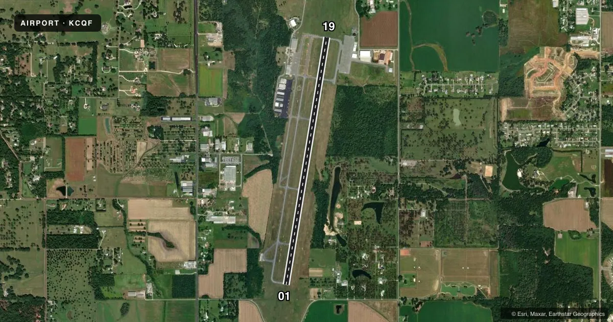
Airport sketch
Runways drawn to scale from FAA survey coordinates, rendered over satellite imagery. Not for navigation.
Approaches & charts
Services on the field
Fuel grades, oxygen, maintenance, ramp storage and lighting — as declared to the FAA by the airport operator.
Fuel & services
- Fuel
- 100LLA+
- Oxygen (bottled)
- HIGH/LOW
- Airframe repair
- Major
- Power plant repair
- Major
- Other services
- AVNCS,INSTR,RNTL
Ramp & ground
- Transient storage
- Tie-down
- Hangar
- Landing fee
- No fee published
- Customs
- Not available
- Lighting schedule
- SEE RMK
- Beacon schedule
- SS-SR
- Beacon
- White / Green (civil land)(WG)
- Wind indicator
- Lighted
- Segmented circle
- No
Fuel & FBOs
Cheapest 100LL and Jet A on the field and nearby. Always confirm with the FBO before taxi.
Airport notes
Surface conditions, obstructions, local procedures, lighting outages and other notes published with each FAA cycle.
General notes
- NOISE ABATEMENT RWY 01 & 19, DEP STRAIGHT OUT TIL RCHG 600 FT AGL.
- FOR CD CTC MOBILE APCH AT 251-662-6236, WHEN APCH CLSD CTC HOUSTON ARTCC AT 281-230-5622.
Lighting notes
- ACTVT REIL RWY 01 & 19; PAPI RWY 01 & 19; HIRL RWY 01/19 - CTAF. HIRL RWY 01/19 PRESET TO LOW INTST; INCR INTST - CTAF.
Runway surface & condition
- 01/19PCR VALUE: 326/F/D/X/T
VFR map & nearby airports
VFR sectional. Tap any ICAO chip to open that airport.
Key facts · KCQF
Answer card- ICAO
- KCQF
- Name
- H L SONNY CALLAHAN
- Location
- FAIRHOPE, ALABAMA
- Elevation
- 91.1 ft MSL
- Traffic pattern altitude
- 1,091.1 ft MSL (1,000 AGL)
- Control tower
- Non-towered (use CTAF)
- Total runways
- 1
- Longest runway
- 01/19 · 6,604 ft
- Published ILS approaches
- 0
- Published frequencies
- 4
- Magnetic variation
- 1°
- Current flight rules
- VFR
- Current wind
- 320° at 6 kt
- Favored runway now
- RWY 01
H L Sonny Callahan Airport sits in Fairhope, Alabama. Field elevation is 91.1 ft MSL. The airport has one runway. Runway 01/19 is 6,604 ft of asphalt and is the longest runway on the field. There is no control tower. CTAF and UNICOM are both 123.0. Approach and departure service is on 118.5 and 269.3 through Mobile.
No ILS approaches are published here. Pattern altitude is not published, so use 1,000 ft AGL for light piston operations unless the current Chart Supplement says otherwise. The field has a single on-field FBO, Flightline First. It carries 100LL and Jet A Prist. Call them at (251) 572-4626 for current services.
This is a non-towered airport with published noise abatement on both runway directions. Depart straight out until reaching 600 ft AGL. Runway 01/19 has PAPI, runway end identifier lights and high intensity lighting that is controlled by CTAF. The lights are preset to low intensity. You can increase them on CTAF. The pavement classification number for the runway is 326/F/D/X/T. If you need clearance delivery, contact Mobile Approach at 251-662-6236. When approach is closed, use Houston ARTCC at 281-230-5622.