METAR & TAF KBFM
Current METAR
Observed 15:53Z
KBFM 271553Z 30007G15KT 10SM BKN080 32/24 A2998 RMK AO2 SLP152 T03220239
- Wind
- 300° @ 7G15 kt
- Visibility
- 10 SM
- Temp / Dew
- 32°C / 24°C
- Altimeter
- 29.98 inHg
- Clouds
- BKN
- Density alt
- 1,998 ft
- Ceiling
- 8,000 ft AGL
- Rules
- VFR
Airport info & contacts
Manager on record, flight service, ARTCC, attendance schedule and pattern altitude — published by the FAA and refreshed every 28 days.
Location
- From city
- 3 NM S
- VFR sectional
- NEW ORLEANS
- ARTCC
- ZHU · HOUSTON
- NOTAM facility
- BFM (NOTAM-D)
Airport manager
- Name
- ANDY WILSON
- Phone
- 251-639-4680
- Address
- P O BOX 88004, MOBILE AL 36608
Flight service · Hours
- FSS ANB
- ANNISTON1-800-WX-BRIEF
- Attendance
- 0700-2300
Frequencies
Tap any row to copy the frequency to your clipboard.
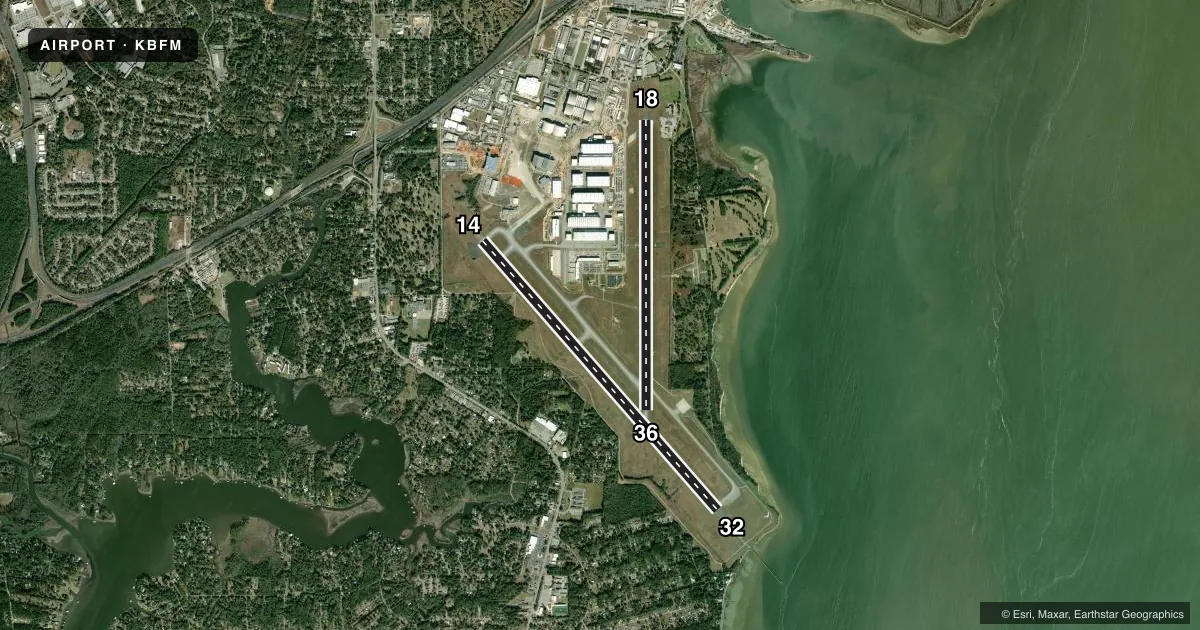
Runways & pattern
Full pagePattern entry · RWY 32
LEFT TRAFFIC| Runway | Heading (°M) | Length | Surface | Traffic |
|---|---|---|---|---|
| 14/32Favored | 138° / 318° | 9,618 ft | ASPH-CONC | 14 R |
| 18/36 | 179° / 359° | 7,800 ft | ASPH-CONC | 36 R |
Runway end performance
| End | TORA | TODA | ASDA | LDA | VGSI | Approach lights | Obstruction |
|---|---|---|---|---|---|---|---|
| 14 | — | — | — | — | PAPI 4-box left(3°) | — | 39', tree, 1535' from thr, 500' R of cntrln, slope 34 |
| 32 | — | — | — | — | PAPI 4-box left(3°) | MALSR | — |
| 18 | — | — | — | — | PAPI 4-box left(3°) | — | 33', pole, 1200' from thr, 0' R of cntrln, slope 30 |
| 36 | — | — | — | — | PAPI 4-box left(3°) | — | 55', trees, 1300' from thr, 400' R of cntrln, slope 20 |
Declared distances in feet. TORA = takeoff run available, TODA = takeoff distance, ASDA = accelerate-stop, LDA = landing distance.
Airport sketch
Runways drawn to scale from FAA survey coordinates, rendered over satellite imagery. Not for navigation.
Approaches & charts
ILS · 1
Services on the field
Fuel grades, oxygen, maintenance, ramp storage and lighting — as declared to the FAA by the airport operator.
Fuel & services
- Fuel
- 100LLA
- Oxygen (bottled)
- Not available
- Oxygen (bulk)
- HIGH/LOW
- Airframe repair
- Major
- Power plant repair
- Major
- Other services
- CARGO,CHTR,INSTR,RNTL,SALES
Ramp & ground
- Transient storage
- Tie-down
- Hangar
- Landing fee
- No fee published
- Customs
- Not available
- Lighting schedule
- SEE RMK
- Beacon schedule
- SS-SR
- Beacon
- White / Green (civil land)(WG)
- Wind indicator
- Lighted
- Segmented circle
- Yes
Fuel & FBOs
Cheapest 100LL and Jet A on the field and nearby. Always confirm with the FBO before taxi.
Airport notes
Surface conditions, obstructions, local procedures, lighting outages and other notes published with each FAA cycle.
General notes
- CONDS NOT MNT WHEN ATCT CLSD.
- HOT CARGO SPACE ASGND TO TWY A BTN RWY 18/36 AND A6
- FOR CD WHEN ATCT CLSD CTC MOBILE APCH AT 251-662-6236. WHEN APCH CLSD CTC HOUSTON ARTCC AT 281-230-5622.
- ARPT MNTN ARFF INDEX B. INDEX C AVBL UPON REQ.
Lighting notes
- DUSK-DAWN. WHEN ATCT CLSD ACTVT MALSR RWY 32 - CTAF. HIRL RWY 14/32 PRESET ON STEP 3 OR HYR BASED ON WX.
Approach & departure obstructions
- 14RWY 14/32 CNTRLN LGTS AVBL DURG ATCT OPER HRS ONLY.
- 32TDZ LGTS AVBL DURG ACTC OPER HRS ONLY.
Other notes
- PRIOR TO FAA ACT.
- MANAGERFAX PHONE 251-694-7667.
VFR map & nearby airports
VFR sectional. Tap any ICAO chip to open that airport.
Key facts · KBFM
Answer card- ICAO
- KBFM
- Name
- MOBILE INTL
- Location
- MOBILE, ALABAMA
- Elevation
- 26.2 ft MSL
- Traffic pattern altitude
- 1,026.2 ft MSL (1,000 AGL)
- Control tower
- Towered · 0700-1900 SUN; 0700-2200 MON; 0330-2200 TUE THRU FRI; 0400-1900 SAT.
- Total runways
- 2
- Longest runway
- 14/32 · 9,618 ft
- Published ILS approaches
- 1
- Published frequencies
- 10
- Magnetic variation
- 1°
- Current flight rules
- VFR
- Current wind
- 300° at 7 kt
- Favored runway now
- RWY 32
Mobile Intl sits in Mobile, Alabama. Field elevation is 26.2 ft MSL. The airport has 2 runways. The longest is runway 14/32 at 9,618 ft. Runway 18/36 is 7,800 ft. The tower is open with published hours. It runs 0700-1900 SUN. 0700-2200 MON. 0330-2200 TUE THRU FRI. 0400-1900 SAT. One ILS approach is published for runway 32. Pattern altitude is not published in the facts, so verify the current Chart Supplement before you fly. Signature Aviation is on the field. It carries 100LL and Jet A. Call (251) 433-2800 for current service details.
This is a low-elevation Gulf Coast field, so weather and runway use can change fast. The published remarks say airport conditions are not maintained when the tower is closed. Lighting is from dusk to dawn. When the tower is closed, activate the MALSR on runway 32 via CTAF. Runway 14/32 centerline lights work only during tower hours. Touchdown zone lights on runway 32 also work only when the tower is open. If you are planning a night arrival or a late departure, check the current Chart Supplement and call the airport or FBO directly for the latest setup. The field also has a published hot cargo area on taxiway A between runway 18/36 and A6. Clearance delivery when the tower is closed goes through Mobile Approach.