METAR & TAF 5R7
5R7 does not publish a METAR.
Showing the nearest reporting station: KBFM (MOBILE INTL) · 12.7 NM away. Conditions at 5R7 may differ.
METAR · KBFM
Observed 12:53Z
KBFM 271253Z 30008KT 10SM BKN110 29/24 A2999 RMK AO2 SLP155 T02890244
- Wind
- 300° @ 8 kt
- Visibility
- 10 SM
- Temp / Dew
- 29°C / 24°C
- Altimeter
- 29.99 inHg
- Clouds
- BKN
- Density alt
- 1,701 ft
- Ceiling
- 11,000 ft AGL
- Rules
- VFR
Airport info & contacts
Manager on record, flight service, ARTCC, attendance schedule and pattern altitude — published by the FAA and refreshed every 28 days.
Location
- From city
- 3 NM NE
- VFR sectional
- NEW ORLEANS
- ARTCC
- ZHU · HOUSTON
- NOTAM facility
- ANB (NOTAM-D)
Airport manager
- Name
- ROBBY GRICE, PRESIDENT
- Phone
- (251) 591-6985
- Address
- 11267 AIRPORT ROAD, IRVINGTON AL 36544
Flight service · Hours
- FSS ANB
- ANNISTON1-800-WX-BRIEF
- Attendance
- ON CALL
Frequencies
Tap any row to copy the frequency to your clipboard.
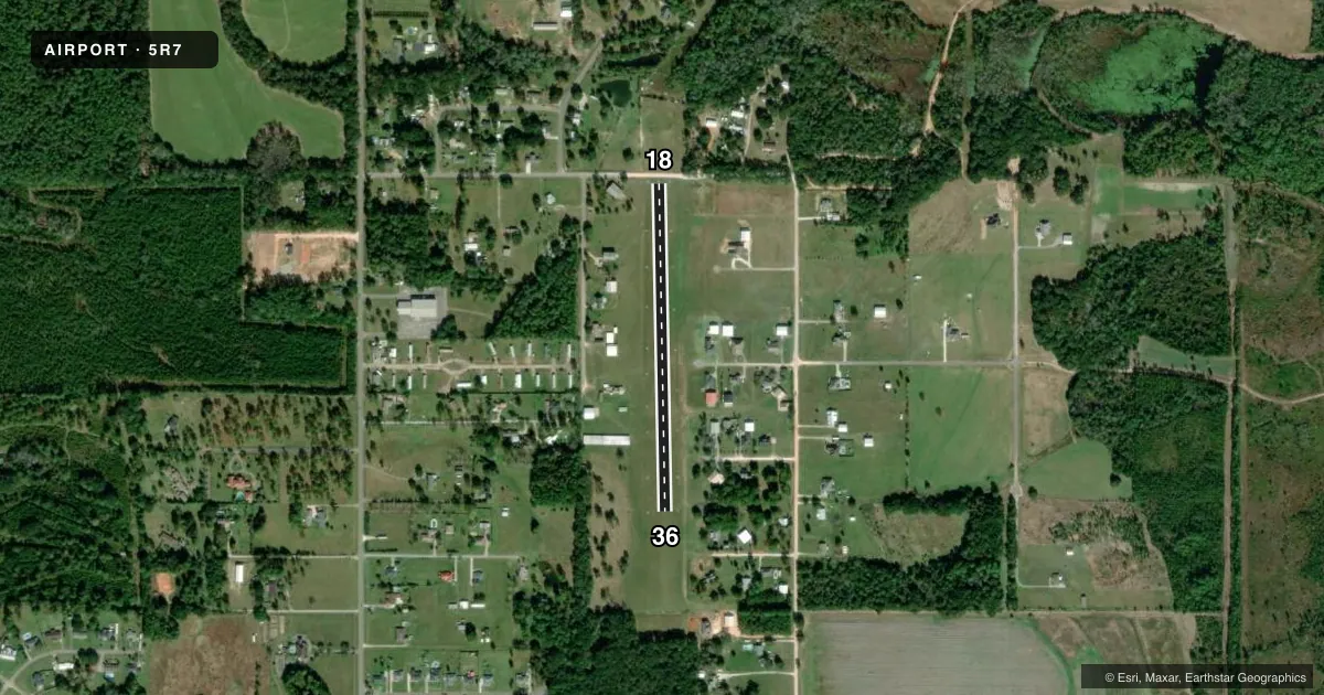
Runways & pattern
Full pagePattern entry · RWY 36
LEFT TRAFFICRunway end performance
| End | TORA | TODA | ASDA | LDA | VGSI | Approach lights | Obstruction |
|---|---|---|---|---|---|---|---|
| 18 | — | — | — | — | — | — | 31', pole, 337' from thr, 52' R of cntrln, slope 10 |
| 36 | — | — | — | — | — | — | 81', trees, 655' from thr, 103' R of cntrln, slope 8 |
Declared distances in feet. TORA = takeoff run available, TODA = takeoff distance, ASDA = accelerate-stop, LDA = landing distance.
Airport sketch
Runways drawn to scale from FAA survey coordinates, rendered over satellite imagery. Not for navigation.
Approaches & charts
Services on the field
Fuel grades, oxygen, maintenance, ramp storage and lighting — as declared to the FAA by the airport operator.
Fuel & services
- Fuel
- Not available
- Oxygen (bottled)
- Not available
- Oxygen (bulk)
- Not available
- Airframe repair
- Not available
- Power plant repair
- Not available
Ramp & ground
- Transient storage
- Tie-down
- Customs
- Not available
- Wind indicator
- Yes
- Segmented circle
- No
Fuel & FBOs
Cheapest 100LL and Jet A on the field and nearby. Always confirm with the FBO before taxi.
Airport notes
Surface conditions, obstructions, local procedures, lighting outages and other notes published with each FAA cycle.
General notes
- FOR CD CTC MOBILE APCH AT 251-662-6236, WHEN APCH CLSD CTC HOUSTON ARTCC AT 281-230-5622.
- ARPT CURRENTLY UNLICENSED BY STATE OF ALABAMA.
Approach & departure obstructions
- 18RWY 18/36 MKD WITH FRANGIBLE PVC PIPE AND WHITE PLASTIC MATS.
Other notes
- VFR WEATHER CONDITIONS ONLY.
- 1FOR ARPT ATTENDANT CALL 251-591-6985
VFR map & nearby airports
VFR sectional. Tap any ICAO chip to open that airport.
Key facts · 5R7
Answer card- ICAO
- 5R7
- Name
- ROY E RAY
- Location
- BAYOU LA BATRE, ALABAMA
- Elevation
- 87 ft MSL
- Traffic pattern altitude
- 1,087 ft MSL (1,000 AGL)
- Control tower
- Non-towered (use CTAF)
- Total runways
- 1
- Longest runway
- 18/36 · 2,000 ft
- Published ILS approaches
- 0
- Published frequencies
- 1
- Magnetic variation
- 2°
- Current flight rules
- VFR
- Current wind
- 300° at 8 kt
- Favored runway now
- RWY 36
ROY E RAY is in Bayou La Batre, Alabama. The field elevation is 87 ft MSL. It has one runway, 18/36, which is 2,000 ft of turf and the longest runway on the field. The airport is non-towered. CTAF is 122.9.
No ILS approaches are published here. Published remarks say the airport is for VFR weather conditions only. They also note that runway 18/36 is marked with frangible PVC pipe and white plastic mats. The airport is currently unlicensed by the State of Alabama. For clearance delivery, contact Mobile Approach at 251-662-6236. When Approach is closed, contact Houston ARTCC at 281-230-5622.
Pattern altitude is not published. Use the standard 1,000 ft AGL for light piston traffic unless the current Chart Supplement says otherwise. The on-field FBO is Roy E. Ray Airport. It carries AVGAS 100LL. Call (251) 824-4538 before you go if you need current service details. This is a small turf strip near the coast, so plan for soft-field technique and check the latest field condition before departure.