METAR & TAF 5R2
5R2 does not publish a METAR.
Showing the nearest reporting station: KPQL (TRENT LOTT INTL) · 12.4 NM away. Conditions at 5R2 may differ.
METAR · KPQL
Observed 14:53Z
KPQL 271453Z VRB04KT 10SM CLR 31/25 A2998 RMK AO2 SLP153 T03110250 50003
- Wind
- VAR @ 4 kt
- Visibility
- 10 SM
- Temp / Dew
- 31°C / 25°C
- Altimeter
- 29.98 inHg
- Clouds
- CLR
- Density alt
- 1,870 ft
- Ceiling
- Unlimited
- Rules
- VFR
Airport info & contacts
Manager on record, flight service, ARTCC, attendance schedule and pattern altitude — published by the FAA and refreshed every 28 days.
Location
- From city
- 3 NM E
- VFR sectional
- NEW ORLEANS
- ARTCC
- ZHU · HOUSTON
- NOTAM facility
- GWO (NOTAM-D)
Airport manager
- Name
- JOHN AUST
- Phone
- 228-617-4274
- Address
- 8600 BLUEBERRY RD, OCEAN SPRINGS MS 39564
Flight service · Hours
- FSS GWO
- GREENWOOD1-800-WX-BRIEF
- Attendance
- Unattended
Frequencies
Tap any row to copy the frequency to your clipboard.
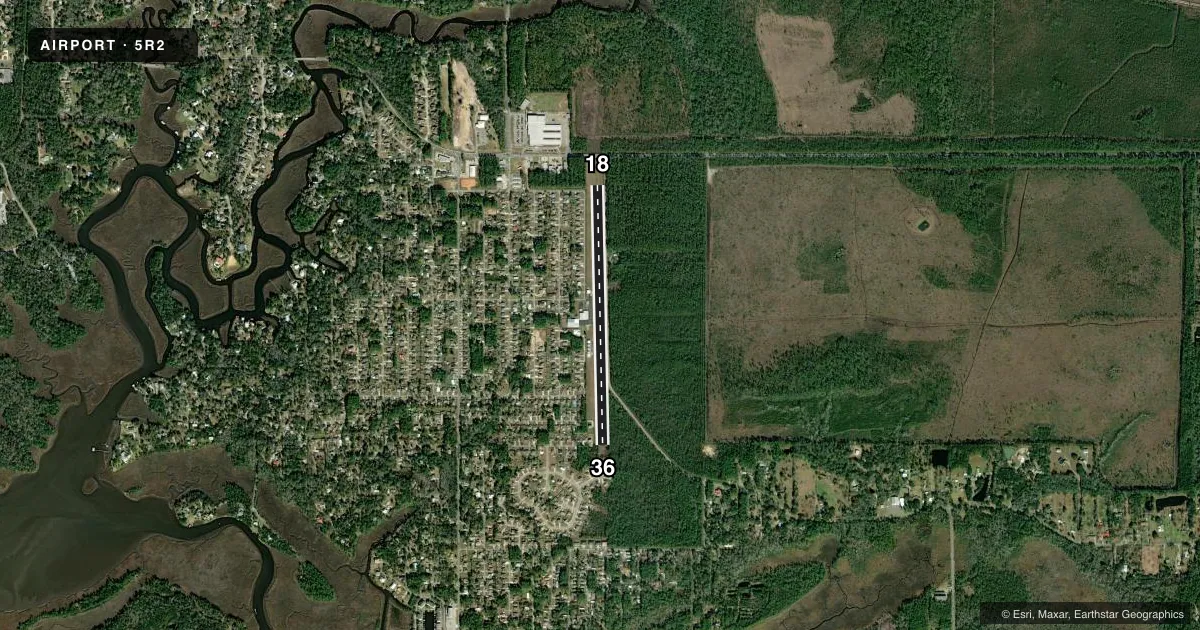
Runways & pattern
Full pagePattern entry · RWY 36
LEFT TRAFFICRunway end performance
| End | TORA | TODA | ASDA | LDA | VGSI | Approach lights | Obstruction |
|---|---|---|---|---|---|---|---|
| 18 | — | — | — | — | — | — | 40', trees, 480' from thr, 120' R of cntrln, slope 7 |
| 36 | — | — | — | — | — | — | 30', trees, 500' from thr, 10' R of cntrln, slope 10 |
Declared distances in feet. TORA = takeoff run available, TODA = takeoff distance, ASDA = accelerate-stop, LDA = landing distance.
Airport sketch
Runways drawn to scale from FAA survey coordinates, rendered over satellite imagery. Not for navigation.
Approaches & charts
Services on the field
Fuel grades, oxygen, maintenance, ramp storage and lighting — as declared to the FAA by the airport operator.
Fuel & services
- Fuel
- 100LL
- Oxygen (bottled)
- Not available
- Oxygen (bulk)
- Not available
- Other services
- INSTR
Ramp & ground
- Transient storage
- Tie-down
- Hangar
- Landing fee
- No fee published
- Customs
- Not available
- Lighting schedule
- SEE RMK
- Beacon schedule
- SEE RMK
- Beacon
- White / Green (civil land)(WG)
- Wind indicator
- Lighted
- Segmented circle
- No
Fuel & FBOs
Cheapest 100LL and Jet A on the field and nearby. Always confirm with the FBO before taxi.
Airport notes
Surface conditions, obstructions, local procedures, lighting outages and other notes published with each FAA cycle.
General notes
- FOR CD CTC GULFPORT APCH AT 228-265-6151, WHEN APCH CLSD CTC HOUSTON ARTCC AT 281-230-5622.
- PILOT MUST PRVD THEIR OWN TIEDOWN ROPES.
Lighting notes
- BCN OTS.
- ACTVT NON STD REIL RWY 18 & 36; MIRL RWY 18/36 - CTAF.
Other notes
- THIS AIRPORT HAS BEEN SURVEYED BY THE NATIONAL GEODETIC SURVEY.
- ACTVT LGTD WINDSOCK - CTAF.
- MANAGERCK AND CREDIT CARD TAKEN AT FBO 228-617-4274.
- MANAGERFBO PHONE 228-617-4274.
VFR map & nearby airports
VFR sectional. Tap any ICAO chip to open that airport.
Key facts · 5R2
Answer card- ICAO
- 5R2
- Name
- OCEAN SPRINGS
- Location
- OCEAN SPRINGS, MISSISSIPPI
- Elevation
- 20 ft MSL
- Traffic pattern altitude
- 1,020 ft MSL (1,000 AGL)
- Control tower
- Non-towered (use CTAF)
- Total runways
- 1
- Longest runway
- 18/36 · 3,500 ft
- Published ILS approaches
- 0
- Published frequencies
- 3
- Magnetic variation
- 2°
- Current flight rules
- VFR
- Current wind
- 000° at 4 kt
- Favored runway now
- RWY 36
Ocean Springs Airport (5R2) sits in Ocean Springs, Mississippi at 20 ft MSL. It has one runway, 18/36, which is 3,500 ft long with an asphalt surface. The field is non-towered. CTAF and UNICOM are both 122.7. Gulfport Approach is on 124.6 for approach and departure work.
No ILS approaches are published here. The pattern altitude is not published. Use the standard 1,000 ft AGL pattern unless ATC or the current Chart Supplement says otherwise. The airport is close to the Gulf Coast, so expect a low, coastal environment with weather and wind changes that can move fast.
Ocean Springs Airport FBO is on the field. It carries 100LL. The published remarks also say the FBO accepts check and credit cards. Pilots should bring their own tiedown ropes. Runway end identifier lights are installed on 18 and 36. Medium intensity runway lights are also on both ends and are controlled on CTAF. The beacon is out of service. A lighted windsock is available on CTAF. For clearance delivery, contact Gulfport Approach. If approach is closed, contact Houston ARTCC. First-time arrivals should verify current lighting and any local procedures before launch.