METAR & TAF KHSA
Current METAR
Observed 12:50Z
KHSA 271250Z 30006KT 10SM CLR 27/25 A3000
- Wind
- 300° @ 6 kt
- Visibility
- 10 SM
- Temp / Dew
- 27°C / 25°C
- Altimeter
- 30.00 inHg
- Clouds
- CLR
- Density alt
- 1,369 ft
- Ceiling
- Unlimited
- Rules
- VFR
Airport info & contacts
Manager on record, flight service, ARTCC, attendance schedule and pattern altitude — published by the FAA and refreshed every 28 days.
Location
- From city
- 8 NM NW
- VFR sectional
- NEW ORLEANS
- ARTCC
- ZHU · HOUSTON
- NOTAM facility
- HSA (NOTAM-D)
Airport manager
- Name
- AUSTIN JENKINS, C.M., ACE
- Phone
- 228-467-7070
- Address
- 7250 STENNIS AIRPORT RD, KILN MS 39556
Flight service · Hours
- FSS GWO
- GREENWOOD1-800-WX-BRIEF
- Attendance
- MON-FRI · 0700-1900
- SAT-SUN · 0800-2000
Frequencies
Tap any row to copy the frequency to your clipboard.
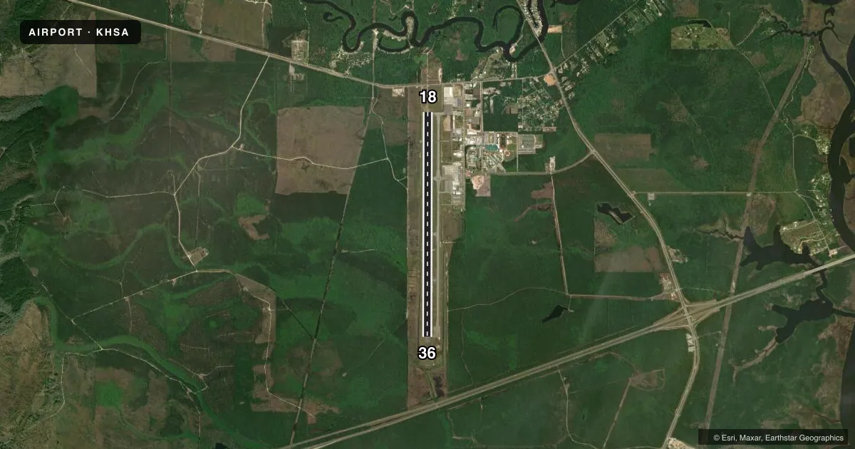
Runways & pattern
Full pagePattern entry · RWY 36
LEFT TRAFFICRunway end performance
| End | TORA | TODA | ASDA | LDA | VGSI | Approach lights | Obstruction |
|---|---|---|---|---|---|---|---|
| 18 | 8,498' | 8,498' | 8,498' | 8,498' | PAPI 4-box left(3°) | MALSR | 40', tree, 2100' from thr, 200' R of cntrln, slope 47 |
| 36 | 8,498' | 8,498' | 8,498' | 8,498' | PAPI 4-box left(3°) | — | 55', trees, 2100' from thr, 0' R of cntrln, slope 34 |
Declared distances in feet. TORA = takeoff run available, TODA = takeoff distance, ASDA = accelerate-stop, LDA = landing distance.
Airport sketch
Runways drawn to scale from FAA survey coordinates, rendered over satellite imagery. Not for navigation.
Approaches & charts
ILS · 1
Services on the field
Fuel grades, oxygen, maintenance, ramp storage and lighting — as declared to the FAA by the airport operator.
Fuel & services
- Fuel
- 100LLA+
- Airframe repair
- Major
- Power plant repair
- Major
- Other services
- INSTR,RNTL,SALES
Ramp & ground
- Transient storage
- Tie-down
- Hangar
- Landing fee
- No fee published
- Customs
- Not available
- Lighting schedule
- SEE RMK
- Beacon schedule
- SS-SR
- Beacon
- White / Green (civil land)(WG)
- Wind indicator
- Lighted
- Segmented circle
- Yes
Fuel & FBOs
Cheapest 100LL and Jet A on the field and nearby. Always confirm with the FBO before taxi.
Airport notes
Surface conditions, obstructions, local procedures, lighting outages and other notes published with each FAA cycle.
General notes
- NMRS LOW FLYING FISH SPOTTER ACFT OPS NEAR SHORELINE BTN GULFPORT & BAY ST. LOUIS.
- BIRDS ON & INVOF ARPT.
- WHEN ATCT CLSD, FOR CD CTC HOUSTON ARTCC AT 281-230-5622.
- AVOID FLYING OVR SCHOOLS .4 NM E OF RWY 18/36 WHEN POSS.
- FBO ATNDD MON-FRI 0700-2000, SAT-SUN 0800-1800.
- AFT HRS CALLOUT - 228-463-2389.
Lighting notes
- ACTVT MALSR RWY 18; REIL RWY 36; PAPI RWY 18 & 36; HIRL RWY 18/36 - CTAF.
Fuel notes
- 100LLFOR FUEL & FBO SVCS AFT HRS CALL 228-463-2389.
Runway surface & condition
- 18/36PCR VALUE: 411/F/B/X/T
Other notes
- FOR ALL RPRS CALL 228-463-2389.
- ACR ACFT OF AT LEAST 31 PAX SEATS OR MORE OR CARGO OPS RQRG INCRD ARFF INDEX, 48 HRS PPR 228-342-5415.
VFR map & nearby airports
VFR sectional. Tap any ICAO chip to open that airport.
Key facts · KHSA
Answer card- ICAO
- KHSA
- Name
- STENNIS INTL
- Location
- BAY ST LOUIS, MISSISSIPPI
- Elevation
- 22.8 ft MSL
- Traffic pattern altitude
- 1,022.8 ft MSL (1,000 AGL)
- Control tower
- Towered · 0700-2100
- Total runways
- 1
- Longest runway
- 18/36 · 8,498 ft
- Published ILS approaches
- 1
- Published frequencies
- 10
- Magnetic variation
- 2°
- Current flight rules
- VFR
- Current wind
- 300° at 6 kt
- Favored runway now
- RWY 36
Stennis Intl is in Bay St. Louis, Mississippi. Field elevation is 22.8 ft MSL. The airport has one runway, 18/36 and it is 8,498 ft long. The tower is open from 0700 to 2100. One ILS approach is published for runway 18. Pattern altitude is not published in the facts, so use standard 1,000 ft AGL for light piston traffic unless the current Chart Supplement says otherwise.
Million Air Stennis is the on-field FBO. It carries 100LL, Jet A and Jet A Prist. After hours service is available by phone. The published remarks also note that the FBO is attended daily during normal business hours. It has shorter Sunday hours. If you need fuel or repairs after hours, call ahead.
This is a coastal field, so expect bird activity near the airport and low-flying fish spotter traffic near the shoreline between Gulfport and Bay St. Louis. Avoid flying over the schools east of runway 18/36 when practical. Runway lighting is pilot-controlled by CTAF. MALSR serves runway 18. REIL serves runway 36. If the tower is closed, clearance delivery goes through Houston ARTCC. Check the current Chart Supplement for any noise or curfew restrictions before flying in.