METAR & TAF 2R5
2R5 does not publish a METAR.
Showing the nearest reporting station: KMOB (MOBILE RGNL) · 11.5 NM away. Conditions at 2R5 may differ.
METAR · KMOB
Observed 11:56Z
KMOB 271156Z 27003KT 10SM FEW050 BKN110 BKN250 26/24 A2998 RMK AO2 SLP149 T02610239 10272 20250 53012
- Wind
- 270° @ 3 kt
- Visibility
- 10 SM
- Temp / Dew
- 26°C / 24°C
- Altimeter
- 29.98 inHg
- Clouds
- BKN
- Density alt
- 1,410 ft
- Ceiling
- 11,000 ft AGL
- Rules
- VFR
Airport info & contacts
Manager on record, flight service, ARTCC, attendance schedule and pattern altitude — published by the FAA and refreshed every 28 days.
Location
- From city
- 2 NM W
- VFR sectional
- NEW ORLEANS
- ARTCC
- ZHU · HOUSTON
- NOTAM facility
- ANB (NOTAM-D)
Airport manager
- Name
- ANDY WILSON
- Phone
- 251-438-7334
- Address
- 1891 NINTH STREET, MOBILE AL 36615
Flight service · Hours
- FSS ANB
- ANNISTON1-800-WX-BRIEF
- Attendance
- Unattended
Frequencies
Tap any row to copy the frequency to your clipboard.
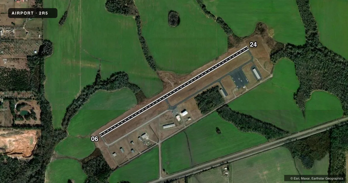
Runways & pattern
Full pagePattern entry · RWY 24
LEFT TRAFFICAirport sketch
Runways drawn to scale from FAA survey coordinates, rendered over satellite imagery. Not for navigation.
Approaches & charts
Services on the field
Fuel grades, oxygen, maintenance, ramp storage and lighting — as declared to the FAA by the airport operator.
Fuel & services
- Fuel
- 100LL
- Oxygen (bottled)
- Not available
- Oxygen (bulk)
- Not available
- Airframe repair
- Not available
- Power plant repair
- Not available
Ramp & ground
- Transient storage
- Tie-down
- Landing fee
- No fee published
- Customs
- Not available
- Lighting schedule
- SEE RMK
- Beacon schedule
- SS-SR
- Beacon
- White / Green (civil land)(WG)
- Wind indicator
- Lighted
- Segmented circle
- Yes
Fuel & FBOs
Cheapest 100LL and Jet A on the field and nearby. Always confirm with the FBO before taxi.
Airport notes
Surface conditions, obstructions, local procedures, lighting outages and other notes published with each FAA cycle.
General notes
- FOR CD CTC MOBILE APCH AT 251-662-6236, WHEN APCH CLSD CTC HOUSTON ARTCC AT 281-230-5622.
Lighting notes
- ACTVT MIRL RWY 06/24 - CTAF.
Fuel notes
- 100LLFUEL 24 HR CREDIT CARD SVC AVBL.
Other notes
- BUILT BEFORE 1959
- MANAGERMOBILE AIRPORT AUTHORITY
VFR map & nearby airports
VFR sectional. Tap any ICAO chip to open that airport.
Key facts · 2R5
Answer card- ICAO
- 2R5
- Name
- ST ELMO
- Location
- ST ELMO, ALABAMA
- Elevation
- 132.4 ft MSL
- Traffic pattern altitude
- 1,132.4 ft MSL (1,000 AGL)
- Control tower
- Non-towered (use CTAF)
- Total runways
- 1
- Longest runway
- 06/24 · 3,998 ft
- Published ILS approaches
- 0
- Published frequencies
- 3
- Magnetic variation
- 0°
- Current flight rules
- VFR
- Current wind
- 270° at 3 kt
- Favored runway now
- RWY 24
ST ELMO (2R5) sits in St Elmo, Alabama. Field elevation is 132.4 ft MSL. The airport has one runway. Runway 06/24 is 3,998 ft of asphalt. There is no control tower. Approach and departure services are handled through Mobile. For clearance delivery, contact Mobile Approach. When approach is closed, contact Houston Center. No ILS approaches are published here, so plan with the current chart and your own weather minimums in mind.
Pattern altitude is not published. Use 1,000 ft AGL for light piston traffic unless local procedures say otherwise. Fuel is available 24 hours with credit card service. The field has medium intensity runway lights on 06/24. They are activated by using CTAF 122.9. The airport manager is the Mobile Airport Authority. This is a small non-towered field, so expect self-announce traffic and keep a close scan on CTAF. If you are coming in at night or in low visibility, verify lighting and current airport status before launch. The airport was built before 1959, so expect a simple layout rather than a modern towered-field setup.