METAR & TAF 4R9
4R9 does not publish a METAR.
Showing the nearest reporting station: KCQF (H L SONNY CALLAHAN) · 17.7 NM away. Conditions at 4R9 may differ.
METAR · KCQF
Observed 13:35Z
KCQF 271335Z AUTO 30005KT 10SM OVC110 28/24 A2998 RMK AO2
- Wind
- 300° @ 5 kt
- Visibility
- 10 SM
- Temp / Dew
- 28°C / 24°C
- Altimeter
- 29.98 inHg
- Clouds
- OVC
- Density alt
- 1,491 ft
- Ceiling
- 11,000 ft AGL
- Rules
- VFR
Airport info & contacts
Manager on record, flight service, ARTCC, attendance schedule and pattern altitude — published by the FAA and refreshed every 28 days.
Location
- From city
- 0 NM NW
- VFR sectional
- NEW ORLEANS
- ARTCC
- ZHU · HOUSTON
- NOTAM facility
- ANB (NOTAM-D)
Airport manager
- Name
- WILLIAM MEREDITH
- Phone
- 251-455-4300
- Address
- 7651 EDGAR ROBERTS RD, IRVINGTON AL 37544
Flight service · Hours
- FSS ANB
- ANNISTON1-800-WX-BRIEF
- Attendance
- Unattended
Frequencies
Tap any row to copy the frequency to your clipboard.
Runways & pattern
Full pagePattern entry · RWY 30
LEFT TRAFFICRunway end performance
| End | TORA | TODA | ASDA | LDA | VGSI | Approach lights | Obstruction |
|---|---|---|---|---|---|---|---|
| 12 | — | — | — | — | PAPI 2-box left(3°) | — | — |
| 30 | — | — | — | — | PAPI 2-box right(3.5°) | — | — |
Declared distances in feet. TORA = takeoff run available, TODA = takeoff distance, ASDA = accelerate-stop, LDA = landing distance.
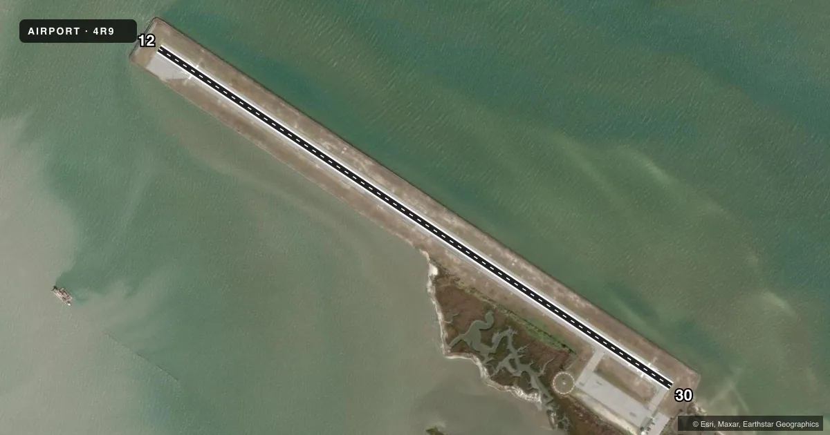
Airport sketch
Runways drawn to scale from FAA survey coordinates, rendered over satellite imagery. Not for navigation.
Approaches & charts
Services on the field
Fuel grades, oxygen, maintenance, ramp storage and lighting — as declared to the FAA by the airport operator.
Fuel & services
- Fuel
- Not available
- Oxygen (bottled)
- Not available
- Oxygen (bulk)
- Not available
- Airframe repair
- Not available
- Power plant repair
- Not available
Ramp & ground
- Transient storage
- Tie-down
- Landing fee
- No fee published
- Customs
- Not available
- Lighting schedule
- SEE RMK
- Beacon schedule
- SS-SR
- Beacon
- White / Green (civil land)(WG)
- Wind indicator
- Lighted
- Segmented circle
- Yes
Fuel & FBOs
Cheapest 100LL and Jet A on the field and nearby. Always confirm with the FBO before taxi.
Airport notes
Surface conditions, obstructions, local procedures, lighting outages and other notes published with each FAA cycle.
General notes
- BIRDS ON & INVOF ARPT.
- FOR CD CTC MOBILE APCH AT 251-662-6236, WHEN APCH CLSD CTC HOUSTON ARTCC AT 281-230-5622.
Lighting notes
- ACTVT PAPI RWY 12 & 30; MIRL RWY 12/30 - CTAF.
Approach & departure obstructions
- 12APCH SLOPE 50:1 TO DSPLCD THR.
Other notes
- VFR ONLY.
VFR map & nearby airports
VFR sectional. Tap any ICAO chip to open that airport.
Key facts · 4R9
Answer card- ICAO
- 4R9
- Name
- JEREMIAH DENTON
- Location
- DAUPHIN ISLAND, ALABAMA
- Elevation
- 4.6 ft MSL
- Traffic pattern altitude
- 1,004.6 ft MSL (1,000 AGL)
- Control tower
- Non-towered (use CTAF)
- Total runways
- 1
- Longest runway
- 12/30 · 3,000 ft
- Published ILS approaches
- 0
- Published frequencies
- 2
- Magnetic variation
- 2°
- Current flight rules
- VFR
- Current wind
- 300° at 5 kt
- Favored runway now
- RWY 30
Jeremiah Denton Airport (4R9) sits on Dauphin Island, Alabama. Field elevation is 4.6 ft MSL. The airport has one runway, 12/30, which is 3,000 ft long with asphalt pavement. There is no control tower. CTAF and UNICOM are both 122.8. No ILS approaches are published here.
Pattern altitude is not published, so use the standard 1,000 ft AGL for light piston operations unless the current Chart Supplement says otherwise. This is a VFR-only field. Birds are reported on and near the airport, so keep a sharp scan on departure and arrival. Runway lighting is medium intensity and controlled by CTAF. PAPI is active on both runway ends. The published remarks also note a 50:1 approach slope to the displaced threshold on runway 12.
For clearance delivery, contact Mobile Approach at 251-662-6236. When approach is closed, contact Houston ARTCC at 281-230-5622. With the field sitting just above sea level on the island, expect coastal conditions to matter more than terrain. Check the current Chart Supplement for any local procedures before you go.