METAR & TAF 5R4
5R4 does not publish a METAR.
Showing the nearest reporting station: KJKA (GULF SHORES INTL/JACK EDWARDS FLD) · 8.4 NM away. Conditions at 5R4 may differ.
METAR · KJKA
Observed 15:55Z
KJKA 271555Z 30011G17KT 10SM CLR 34/24 A2995
- Wind
- 300° @ 11G17 kt
- Visibility
- 10 SM
- Temp / Dew
- 34°C / 24°C
- Altimeter
- 29.95 inHg
- Clouds
- CLR
- Density alt
- 2,335 ft
- Ceiling
- Unlimited
- Rules
- VFR
Airport info & contacts
Manager on record, flight service, ARTCC, attendance schedule and pattern altitude — published by the FAA and refreshed every 28 days.
Location
- From city
- 3 NM NW
- VFR sectional
- NEW ORLEANS
- ARTCC
- ZJX · JACKSONVILLE
- NOTAM facility
- ANB (NOTAM-D)
Airport manager
- Name
- RACHEL KEITH
- Phone
- 251-943-1545
- Address
- 510 AIRPORT DR, FOLEY AL 36535
Flight service · Hours
- FSS ANB
- ANNISTON1-800-WX-BRIEF
- Attendance
- 0800-1700
Frequencies
Tap any row to copy the frequency to your clipboard.
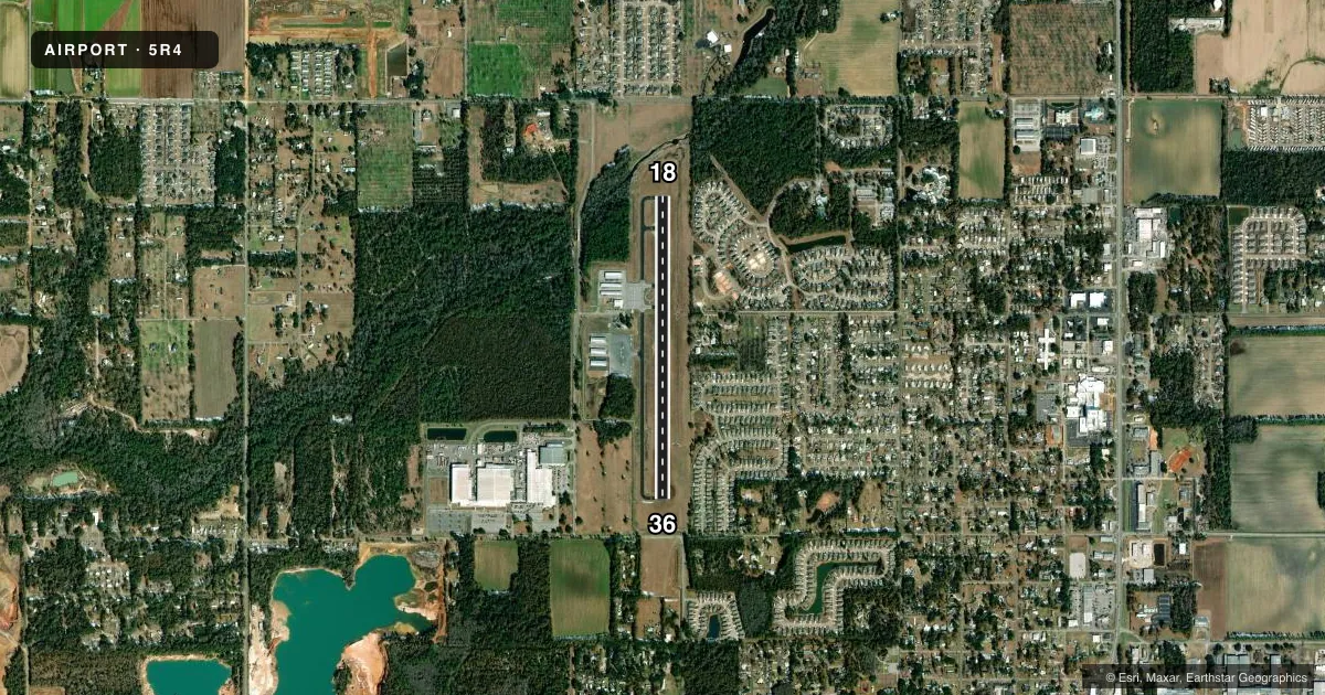
Runways & pattern
Full pagePattern entry · RWY 36
LEFT TRAFFICRunway end performance
| End | TORA | TODA | ASDA | LDA | VGSI | Approach lights | Obstruction |
|---|---|---|---|---|---|---|---|
| 18 | — | — | — | — | PAPI 2-box left(3°) | — | 60', tree, 1308' from thr, 205' R of cntrln, slope 18 |
| 36 | — | — | — | — | PAPI 2-box left(3°) | — | 91', road, 1797' from thr, 200' R of cntrln, slope 17 |
Declared distances in feet. TORA = takeoff run available, TODA = takeoff distance, ASDA = accelerate-stop, LDA = landing distance.
Airport sketch
Runways drawn to scale from FAA survey coordinates, rendered over satellite imagery. Not for navigation.
Approaches & charts
Services on the field
Fuel grades, oxygen, maintenance, ramp storage and lighting — as declared to the FAA by the airport operator.
Fuel & services
- Fuel
- 100LL
- Oxygen (bottled)
- Not available
- Oxygen (bulk)
- Not available
- Airframe repair
- Major
- Power plant repair
- Major
- Other services
- INSTR,RNTL
Ramp & ground
- Transient storage
- Tie-down
- Landing fee
- No fee published
- Customs
- Not available
- Lighting schedule
- SEE RMK
- Beacon schedule
- SS-SR
- Beacon
- White / Green (civil land)(WG)
- Wind indicator
- Lighted
- Segmented circle
- Yes
Fuel & FBOs
Cheapest 100LL and Jet A on the field and nearby. Always confirm with the FBO before taxi.
Airport notes
Surface conditions, obstructions, local procedures, lighting outages and other notes published with each FAA cycle.
General notes
- EXTSV STUDENT TRNG.
- CIRCLING APCH NA EAST OF RWY. VOLUNTARY NOISE ABATEMENT PROC IN EFCT MON-SUN NGT TIME. VOLUNTARY RSTRS ON TOUCH AND GO, STOP AND GO, OR HEL OPS MON-SUN NGT TIME. RWY 18 NGT TIME PREFERENTIAL USE RWY FOR ALL ACFT DEP WHEN WINDS PERMIT.
- LTD PRKG ON NORTH RAMP. TSNT ACFT URGED TO BRING TIE-DOWN ROPES FOR SOUTH RAMP PKNG. NO RAMP FEES EXCP ACFT OVER NGT PRKG.
- FOR CD CTC PENSACOLA APCH AT 850-266-6884 OR 850-266-6885.
Lighting notes
- ACTVT PAPI RWY 18 & 36; MIRL RWY 18/36 - CTAF. MIRL RWY 18/36 PRESET LOW INTST; INCR INTST - CTAF.
Fuel notes
- 100LLFULL SVC AVGAS DURG NML HRS ONLY.
Approach & departure obstructions
- 18HOLD SHORT MARKINGS ARE FAIR CONDITION
- 36PAPI UNUSBL BYD 6 DEG LEFT OF CNTRLN.
Other notes
- VFR OPS ONLY.
VFR map & nearby airports
VFR sectional. Tap any ICAO chip to open that airport.
Key facts · 5R4
Answer card- ICAO
- 5R4
- Name
- HOLK FLD AT FOLEY MUNI
- Location
- FOLEY, ALABAMA
- Elevation
- 74.3 ft MSL
- Traffic pattern altitude
- 1,074.3 ft MSL (1,000 AGL)
- Control tower
- Non-towered (use CTAF)
- Total runways
- 1
- Longest runway
- 18/36 · 3,700 ft
- Published ILS approaches
- 0
- Published frequencies
- 5
- Magnetic variation
- 2°
- Current flight rules
- VFR
- Current wind
- 300° at 11 kt
- Favored runway now
- RWY 36
HOLK FLD AT FOLEY MUNI sits in Foley, Alabama at 74.3 ft MSL. It has one runway, 18/36, which is 3,700 ft of asphalt. This is a non-towered field with CTAF and UNICOM on 123.05. No ILS approaches are published. Pattern altitude is not published, so use the standard 1,000 ft AGL for light piston traffic unless the current FAA Chart Supplement says otherwise.
The field is VFR only. That matters here. If you are planning IFR work, clearance delivery is handled through Pensacola Approach. The airport also has extensive student training, so expect training traffic in the pattern. Night operations have published voluntary noise abatement. Runway 18 is the preferred departure runway at night when winds allow. Circling is not authorized east of the runway. The PAPI and medium intensity runway lights are activated on CTAF. The runway lights are preset to low intensity, so you may need to step them up on the radio.
Lightning Aviation is on the field. It carries 100LL. Full service avgas is available during normal hours only. Limited parking is available on the north ramp. Transient aircraft should bring tie-down ropes for south ramp parking. There are no ramp fees except for overnight parking. If you are new to 5R4, plan for a small, training-heavy airport with simple pavement, no tower and a few local procedures that matter at night.