METAR & TAF 82J
82J does not publish a METAR.
Showing the nearest reporting station: KPNS (PENSACOLA INTL) · 9.5 NM away. Conditions at 82J may differ.
METAR · KPNS
Observed 12:53Z
KPNS 271253Z AUTO 30008KT 10SM FEW080 28/24 A2996 RMK AO2 SLP145 T02830239
- Wind
- 300° @ 8 kt
- Visibility
- 10 SM
- Temp / Dew
- 28°C / 24°C
- Altimeter
- 29.96 inHg
- Clouds
- FEW
- Density alt
- 1,550 ft
- Ceiling
- Unlimited
- Rules
- VFR
Airport info & contacts
Manager on record, flight service, ARTCC, attendance schedule and pattern altitude — published by the FAA and refreshed every 28 days.
Location
- From city
- 7 NM SW
- VFR sectional
- NEW ORLEANS
- ARTCC
- ZJX · JACKSONVILLE
- NOTAM facility
- GNV (NOTAM-D)
Airport manager
- Name
- KENNY BROWN
- Phone
- 850-453-4181
- Address
- 9750 AILERON AVE, PENSACOLA FL 32506
Flight service · Hours
- FSS GNV
- GAINESVILLE1-800-WX-BRIEF
- Attendance
- MON-FRI · 0900-1700
Frequencies
Tap any row to copy the frequency to your clipboard.
Runways & pattern
Full pagePattern entry · RWY 36
LEFT TRAFFICRunway end performance
| End | TORA | TODA | ASDA | LDA | VGSI | Approach lights | Obstruction |
|---|---|---|---|---|---|---|---|
| 18 | — | — | — | — | — | — | 23', trees, 345' from thr, 0' R of cntrln, slope 15 |
| 36 | — | — | — | — | — | — | 16', trees, 145' from thr, 30' R of cntrln, slope 9 |
Declared distances in feet. TORA = takeoff run available, TODA = takeoff distance, ASDA = accelerate-stop, LDA = landing distance.
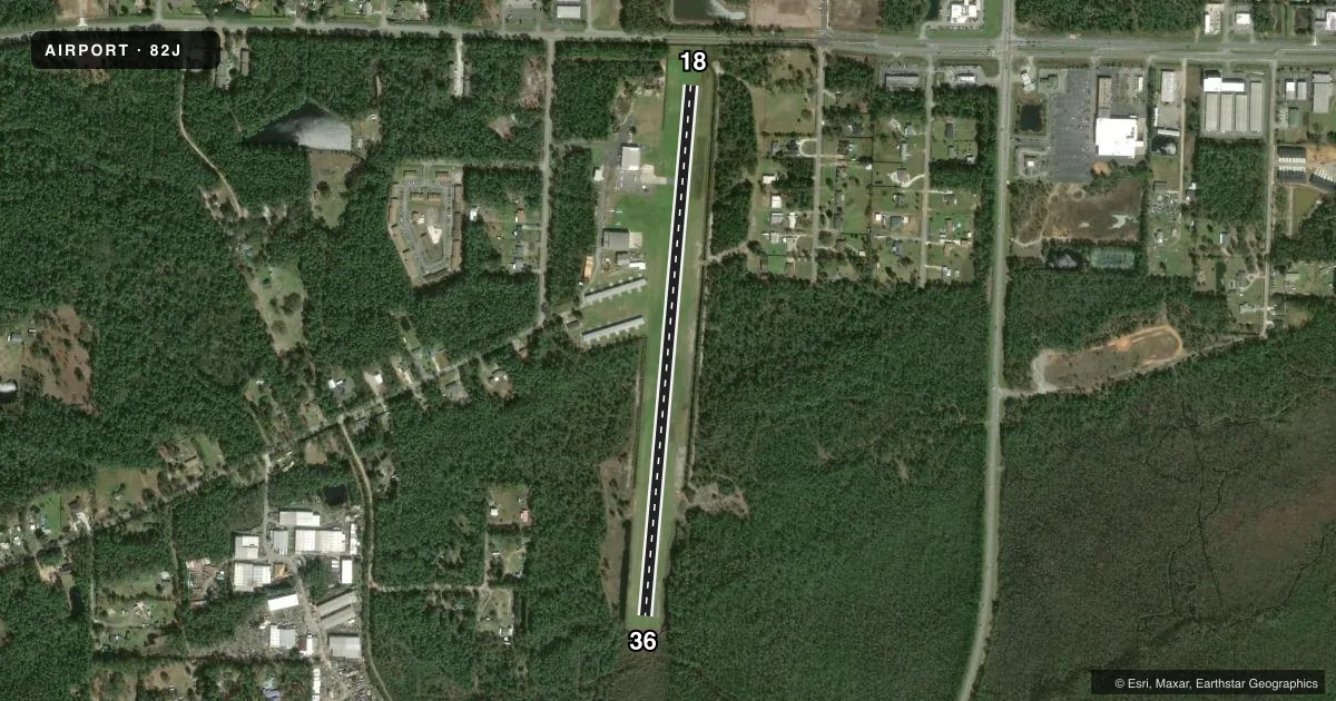
Airport sketch
Runways drawn to scale from FAA survey coordinates, rendered over satellite imagery. Not for navigation.
Approaches & charts
Services on the field
Fuel grades, oxygen, maintenance, ramp storage and lighting — as declared to the FAA by the airport operator.
Fuel & services
- Fuel
- 100LLA+
- Oxygen (bottled)
- Not available
- Oxygen (bulk)
- Not available
- Airframe repair
- Major
- Power plant repair
- Major
- Other services
- AMB,INSTR,RNTL,SURV
Ramp & ground
- Transient storage
- Tie-down
- Hangar
- Landing fee
- No fee published
- Customs
- Not available
- Lighting schedule
- SEE RMK
- Wind indicator
- Yes
- Segmented circle
- No
Fuel & FBOs
Cheapest 100LL and Jet A on the field and nearby. Always confirm with the FBO before taxi.
Airport notes
Surface conditions, obstructions, local procedures, lighting outages and other notes published with each FAA cycle.
General notes
- APCH AND DEP NORTH OF THE ARPT
- ARPT LIES WITHIN 3 NM OF NAS PENSACOLA SHERMAN FIELD (NPA).
- FREQUENT FLIGHT DEMONSTRATIONS AND PRACTICE AIRSHOWS AT NPA.
- FOR CD CTC PENSACOLA APCH AT 850-266-6884 OR 850-266-6885.
Lighting notes
- ACTVT LIRL RWY 18/36 - CTAF.
Fuel notes
- 100LL24 HR FUEL AVBL.
Runway surface & condition
- 18/36RWY LGTS 200 FT SPACING USING LEDS. RWY 18/36 MKD WITH PAVERS & LGTS.
Approach & departure obstructions
- 18APCH RATIO 20:1 TO DSPLCD THLD.
Other notes
- EXISTED PRIOR TO 1959.
- 1AFT HRS CALL 850 453 4181
- OWNERTHOMAS BROWN
- 18/3680 FT WRN PTN OF RWY IS TURF, 40 FT CNTR PTN OF RWY IS ASPH, 20 FT ERN PTN IS TURF.
VFR map & nearby airports
VFR sectional. Tap any ICAO chip to open that airport.
Key facts · 82J
Answer card- ICAO
- 82J
- Name
- ROSCOE FLD
- Location
- PENSACOLA, FLORIDA
- Elevation
- 32 ft MSL
- Traffic pattern altitude
- 1,032 ft MSL (1,000 AGL)
- Control tower
- Non-towered (use CTAF)
- Total runways
- 1
- Longest runway
- 18/36 · 3,225 ft
- Published ILS approaches
- 0
- Published frequencies
- 2
- Magnetic variation
- 1°
- Current flight rules
- VFR
- Current wind
- 300° at 8 kt
- Favored runway now
- RWY 36
Roscoe Fld is in Pensacola, Florida. Field elevation is 32 ft MSL. The airport has one runway, 18/36, at 3,225 ft. It is not towered. CTAF and UNICOM are both 122.8. No ILS approaches are published.
Pattern altitude is not published. Use the standard 1,000 ft AGL for light piston traffic unless the current Chart Supplement says otherwise. The field sits close to NAS Pensacola Sherman Field, within 3 NM. Expect military traffic in the area. Published remarks also say approach and departure are north of the airport. That is worth checking before you go in.
Ferguson Airport is on the field. It carries 100LL and Jet A. Fuel is available 24 hours a day. After hours, call Ferguson Airport at 850-453-4181. Runway 18/36 has LED lights spaced 200 feet apart. The runway is marked with pavers. The western and eastern ends are turf with an asphalt center section. The published remarks also note an 80-foot western turf portion, a 40-foot asphalt center portion and a 20-foot eastern turf portion. Clearance delivery for the area is handled through Pensacola Approach at 850-266-6884 or 850-266-6885. Check the current Chart Supplement for any local noise or operating notes before flying in.