METAR & TAF 1J9
1J9 does not publish a METAR.
Showing the nearest reporting station: KVPS (EGLIN AFB/DESTIN-FT WALTON BEACH) · 16.4 NM away. Conditions at 1J9 may differ.
METAR · KVPS
Observed 12:55Z
KVPS 271255Z AUTO 31008KT 10SM CLR 29/28 A2993 RMK AO2 LTG DSNT SE SLP141 T02890283 $
- Wind
- 310° @ 8 kt
- Visibility
- 10 SM
- Temp / Dew
- 29°C / 28°C
- Altimeter
- 29.93 inHg
- Clouds
- CLR
- Density alt
- 1,695 ft
- Ceiling
- Unlimited
- Rules
- VFR
Airport info & contacts
Manager on record, flight service, ARTCC, attendance schedule and pattern altitude — published by the FAA and refreshed every 28 days.
Location
- From city
- 2 NM E
- VFR sectional
- NEW ORLEANS
- ARTCC
- ZJX · JACKSONVILLE
- NOTAM facility
- GNV (NOTAM-D)
Airport manager
- Name
- SANDY WILLIAMS
- Phone
- 850-244-1313
- Address
- P.O. BOX 1075, P.O. BOX, FT WALTON BEACH FL 32549
Flight service · Hours
- FSS GNV
- GAINESVILLE1-800-WX-BRIEF
- Attendance
- 1000-DUSK
Frequencies
Tap any row to copy the frequency to your clipboard.
Runways & pattern
Full pagePattern entry · RWY 36
LEFT TRAFFICRunway end performance
| End | TORA | TODA | ASDA | LDA | VGSI | Approach lights | Obstruction |
|---|---|---|---|---|---|---|---|
| 18 | — | — | — | — | — | — | 73', trees, 440' from thr, 125' R of cntrln, slope 6 |
| 36 | — | — | — | — | — | — | 3', brush, 57' from thr, 45' R of cntrln, slope 20 |
Declared distances in feet. TORA = takeoff run available, TODA = takeoff distance, ASDA = accelerate-stop, LDA = landing distance.
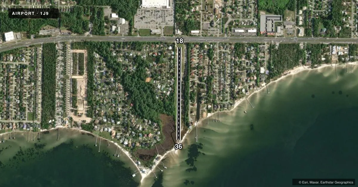
Airport sketch
Runways drawn to scale from FAA survey coordinates, rendered over satellite imagery. Not for navigation.
Approaches & charts
Services on the field
Fuel grades, oxygen, maintenance, ramp storage and lighting — as declared to the FAA by the airport operator.
Fuel & services
- Fuel
- Not available
- Oxygen (bottled)
- Not available
- Oxygen (bulk)
- Not available
- Airframe repair
- Not available
- Power plant repair
- Not available
Ramp & ground
- Transient storage
- Not published
- Landing fee
- No fee published
- Customs
- Not available
- Wind indicator
- Yes
- Segmented circle
- No
Fuel & FBOs
Cheapest 100LL and Jet A on the field and nearby. Always confirm with the FBO before taxi.
Airport notes
Surface conditions, obstructions, local procedures, lighting outages and other notes published with each FAA cycle.
General notes
- BANNER TOWING.
- HEL MORE THAN 2500 LB NA.
- FOR CD CTC EGLIN APCH 850-882-9152 OR 850-882-9151.
Runway surface & condition
- 18/36DEP RWY 18; ARR RWY 36. RWY SLOPES TO 2 FT AT S END. UNLGTD BRUSH, TREES, PRKG & BLDG 65-125 FT W OF CNTRLN FULL LEN.
Approach & departure obstructions
- 18WHITE CONES.
- 36WHITE CONES.
Other notes
- EXISTED PRIOR TO 1959.
- MANAGERPHYSICAL ADDRESS: 9401 NAVARRE PKWY NAVARRE, FL 32566
- 18/36BARE SPOTS SOFT & SANDY S OF MID POINT.
VFR map & nearby airports
VFR sectional. Tap any ICAO chip to open that airport.
Key facts · 1J9
Answer card- ICAO
- 1J9
- Name
- FORT WALTON BEACH
- Location
- NAVARRE, FLORIDA
- Elevation
- 22 ft MSL
- Traffic pattern altitude
- 1,022 ft MSL (1,000 AGL)
- Control tower
- Non-towered (use CTAF)
- Total runways
- 1
- Longest runway
- 18/36 · 2,100 ft
- Published ILS approaches
- 0
- Published frequencies
- 2
- Magnetic variation
- 1°
- Current flight rules
- VFR
- Current wind
- 310° at 8 kt
- Favored runway now
- RWY 36
Fort Walton Beach Airport (1J9) sits in Navarre, Florida. Field elevation is 22 ft MSL. It has one runway. Runway 18/36 is 2,100 ft of turf, so plan for short-field performance and soft-field handling. No tower is published. CTAF and UNICOM are both 122.7.
No ILS approaches are published here. Pattern altitude is not published, so use the standard 1,000 ft AGL for light piston operations unless the current FAA Chart Supplement says otherwise. The field has no on-field FBOs listed. Check with the airport operator or the FBO directly by phone before arrival if you need current services.
The published remarks matter here. Runway 18 and Runway 36 are marked with white cones. Departures use runway 18. Arrivals use runway 36. The runway slopes to 2 ft at the south end. There are bare spots that are soft and sandy south of midfield. There is also unlighted brush, trees, parking and buildings 65 to 125 ft west of the centerline along the full length of the runway. Banner towing is conducted at the airport. Helicopters over 2,500 lb are not authorized. For clearance delivery, contact Eglin Approach by phone before you go.