METAR & TAF KVPS
Current METAR
Observed 12:55Z
KVPS 271255Z AUTO 31008KT 10SM CLR 29/28 A2993 RMK AO2 LTG DSNT SE SLP141 T02890283 $
- Wind
- 310° @ 8 kt
- Visibility
- 10 SM
- Temp / Dew
- 29°C / 28°C
- Altimeter
- 29.93 inHg
- Clouds
- CLR
- Density alt
- 1,772 ft
- Ceiling
- Unlimited
- Rules
- VFR
Airport info & contacts
Manager on record, flight service, ARTCC, attendance schedule and pattern altitude — published by the FAA and refreshed every 28 days.
Location
- From city
- 1 NM SW
- VFR sectional
- NEW ORLEANS
- ARTCC
- ZJX · JACKSONVILLE
- NOTAM facility
- VPS (NOTAM-D)
Airport manager
- Name
- TRACY STAGE
- Phone
- 850-651-7160
- Address
- 1701 STATE ROAD 85N, EGLIN AFB FL 32542
Flight service · Hours
- FSS GNV
- GAINESVILLE1-800-WX-BRIEF
- Attendance
- ALL
Frequencies
Tap any row to copy the frequency to your clipboard.
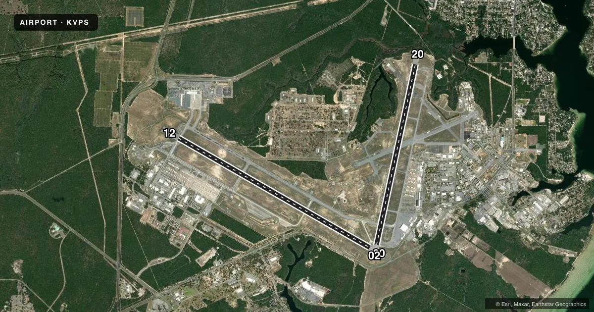
Runways & pattern
Full pagePattern entry · RWY 30
LEFT TRAFFIC| Runway | Heading (°M) | Length | Surface | Traffic |
|---|---|---|---|---|
| 12/30Favored | 117° / 297° | 12,004 ft | ASPH-CONC | Standard L |
| 02/20 | 9° / 189° | 10,012 ft | ASPH | Standard L |
Runway end performance
| End | TORA | TODA | ASDA | LDA | VGSI | Approach lights | Obstruction |
|---|---|---|---|---|---|---|---|
| 12 | — | — | — | — | PAPI 4-box left(3°) | — | — |
| 30 | — | — | — | — | PAPI 4-box left(2.5°) | ALSF1 | — |
| 02 | — | — | — | — | PAPI 4-box left(3°) | ALSF1 | — |
| 20 | — | — | — | — | PAPI 4-box left(2.8°) | ALSF1 | — |
Declared distances in feet. TORA = takeoff run available, TODA = takeoff distance, ASDA = accelerate-stop, LDA = landing distance.
Airport sketch
Runways drawn to scale from FAA survey coordinates, rendered over satellite imagery. Not for navigation.
Approaches & charts
ILS · 2
Services on the field
Fuel grades, oxygen, maintenance, ramp storage and lighting — as declared to the FAA by the airport operator.
Fuel & services
- Fuel
- A
- Oxygen (bottled)
- Not available
- Oxygen (bulk)
- Not available
- Airframe repair
- Not available
- Power plant repair
- Not available
Ramp & ground
- Transient storage
- Not published
- Landing fee
- No fee published
- Customs
- Not available
- Lighting schedule
- SS-SR
- Beacon schedule
- SS-SR
- Beacon
- White / Green (civil land)(WG)
- Wind indicator
- Yes
- Segmented circle
- No
Fuel & FBOs
Cheapest 100LL and Jet A on the field and nearby. Always confirm with the FBO before taxi.
Airport notes
Surface conditions, obstructions, local procedures, lighting outages and other notes published with each FAA cycle.
General notes
- RWY DIST MRKRS ON BOTH RWYS.
- TWY PARL TO RWY 12/30 MAY BE MISTAKEN FOR RWY.
- HEAVY TFC 10 NM NORTH OF ARPT INVOF CRESTVIEW/BOB SIKES ARPT.
- LARGE MIGRATORY BIRDS PRESENT YEAR ROUND ON & INVOF ARPT.
- FUEL: A++, 100LL
- CAUTION: HIGH VOLUME OF NAVY T-6 ANF B-06 TRAINING ACFT NEAR CEW VORTAC.
- REGIONAL WX BRIEFINGS; CLSD WKNDS AND HOLS.
- BEARING STRENGTH RWY 02/20: ST150; SBTT600; TT500; TD T800; TRT600
- A-GEAR: 8 PT TIE-DOWNS ON ALL BAK-12. RWY 02-20 NML A-G CONFIGURATION: BAK-12B APCH END DISCONNECTED, DEP END CONNECTED. MB100 CONFIGURED FOR UNI-DIREC, DEP END ARRESTMENTS ONLY. MB100 APCH END DISCONNECTED, DEP END CONNECTED. APCH END AVBL WITH 20 MIN PN 1215-0515Z++ MON-FRI, AVBL WITH 2 HR PN SAT, SUN, AND HOL. RWY 12/30 NML A-GEAR CONFIGURATION: BAK-12B ALWAYS CONNECTED. MB100 CONFIGURED FOR UNI-DIREC, DEP END ARRESTMENTS ONLY. MB-100 APCH END DISCONNECTED, DEP END CONNECTED. DO NOT ENGAGE MB100 ON APCH END. POTENTIAL FOR TAIL HOOK SKIP EXISTS, DUE TO UNEVEN ASPHALT PAVEMENT AT MB100.
- SERVICE-JASU: (AM32A-60)(AM32A-95)(B809)(SGNSC)(MC-2A)(MC20).
- FLUID: ADI-LTD; SP PRESAIR LHOX LOX
- OIL: O-128-132-133-148-156; SOAP/JOAP - NOT AVBL WEKEND AND HOL.
- RSTD: TWY B RSTD TO MISSION ESSENTIAL ACFT ONLY. PPR MIN 24 HR. CTC AM OPS DSN 872-5313/5406, C850-882-5313/5406 OR VIA EMAIL AT 96OSS.OSAM.EGLINBASEOPS@US.AF.MIL. PPR 24 HR. PPR ARR/DEP TIMES ARE STRICTLY ENFORCED. TRAN ACFT ARR LATE EXP MIN 2 HR DELAY. TRAN AIRCREWS RPT LATE FOR SKED DEP EXP MIN 2 HR DELAY.
- RSTD: ALL AMC OR ACFT WITH DV CODE 6 OR ABV CTC AM OPS 30 MN PRIOR TO LDG.
- CAUTION: OBST (HGR) 211 FT LCTD APRX FIRST 1000 FT E OF ACPH END RWY 02. DUR VFR POSS CONFLICTING TFC. VFR ARR/DEP CTC EGLIN APP FOR CLNC TO ENTER EGLIN CORRIDOR SE OF CRESTVIEW. UNLGTD OBST ON AFLD.
- CAUTION: HI MID-AIR POTENTIAL, EXER EXTREME VIGILANCE. DESTIN EXECUTIVE ARPT IS A CTLD ARPT 1200-0400Z++, 6 NM SE OF EGLIN AFB.
- CAUTION: ACFT FLYING WITHIN 2NM OF KDTS AT OR BLW 1000' MAY NOT BE MNT EGLIN APP FREQ. SPECIAL AIR TRAFFIC RULES-PART 93, SEE REGULATORY NTC.
- TFC PAT: OVERHEAD TFC RWY 20 NML PROHIBITED.
- CSTMS/AG/IMG: LTD SVC, NO RESIDENT CSTMS AGENT. AVBL FOR BASE ASGN ACFT AND THEIR DEPLOYMENTS ONLY. 24 HR ADVANCE NOTICE RQR. ALL OTHER ACFT MUST CLEAR CSTMS PRIOR TO ARR T EGLIN AFB.
- MISC: EXP EXTV FLT PLAN FILING/DEP, REFUEL AND MAINT DELAYS DUR PEAK MSN PERIODS/WKEND. THE MIDDLE PORTION, 10,000' OF RWY 12-30, IS ASPHALTIC CONCRETE. DEP ACFT ASGN A HDG TO FLY, SHALL INITIATE THEIR TURN WITHIN 1 NM OF DEP END RWY.
- MISC: STD USAF RSRS APPLIED.
- MISC: COMSEC DOCUMENTS NOT AVBL FOR ISSUE. TRAN FLIGHT CREW CLASSIFIED STOR AVBL IN BASE OPS TO SECRET AND BLW.
- TRAN ALERT: TRAN ACFT MUST ARR/DEP DUR NML DUTY HR. OPR 1300-0400Z++MON - FRI; 1500 - 2300Z++ SAT-SUN AND HOL EXC THANKSGIVING, CHRISTMAS, AND NEW YEAR. TRAN ACFT NOT ALLOWED WHEN TRAN ALERT NOT AVBL. TRAN ACFT MUST USE FLW-ME TO PARK. PROGRESSIVE TAXI NOT AVBL. NO TRAN ACFT CAN ARR/DEP PRIOR TO 1330Z++ MON - FRI; 1300Z ++ SAT-SUN AND HOL AND MUST ARR/DEP NLT 0330Z++MON-FRI; 2300Z++ SAT-SUN AND HOL.
- TRAN ALERT: ARR/DEP OT EXTREMELY LTD AND REQUIRES STRICT 24 HR ADVANCED APVL. WKEND AND HOL MAINT CAPABILITY EXTREMELY LTD AND MAY BE POSTPNED TIL NEXT DUTY DAY. FLEET SVC NOT AVBL.
- RSTD: TRAN ALERT WILL NOT SUPPORT LCL, ROUND ROBINS, OR OUT AND BACK FLT BY TRAN ACFT.
- CAUTION: UNCTL VEHICLE ON MOVEMENT AREA. RWY 20 NSTD OVRN 740 X 300, RWY 02 NSTD OVRN 500 X 300.
- CAUTION: INCR POTENTIAL FOR HYDROPLANING RWY 12-30 DUE TO POLISHED CONCRETE ON 1ST 1000 FT RWY 12-30, PONDING AT TWY M.
- PREDOMINANT AFLD VIS OBST NW TO NNE, INCL APCH ENDS OF RWY 20 AND RWY 12. AFLD WX MNT BY AN/FMQ-19 ASOS. REMOTE BRIEFING AVBL 26 OWS BARKSDALE AFB DSN 331-2651 C318-529-2651.
- CAUTION: SPECIAL AIR TFC RULES APPLY; SEE PART 93.83 SPECIAL AIR TFC RULES.
- AIRPORT (VPS) IS A JOINT USE FACILITY WITH THE USAF. CONTACT EGLIN AFB TWR AT 118.2. NO GND HANDLING SERVICES FOR GA AVAILABLE AT VPS. FULL SVC GENERAL AVIATION FACILITIES ARE AVBL AT DTS (6 NM SE) OR CEW (18 NM N).
- CAUTION: WIND SHEAR COND MAY EXIST THRU SHORT-FINAL APCH AND TOUCHDOWN DUE TO STRONG SEA BREEZE.
- COMMUNICATIONS-PMSV METRO: PMSV MONITORING AND FULL SVC 24 HOURS.
- CAUTION: MANDATORY VFR HOLD SIGN MISSING AT TWY M WEST.
- MISC: FULL SVC 0600Z++ MON - 0600Z++ SAT, CLSD WKEND/HOL, OT SVC UNAVBL. AFLD OBS AUGMENTED H24/D7. REMOTE BRIEFING AVBL 96 WS EGLIN AFB DSN 882-4800, C850-882-4800.
- ALL DEP RQR TO MAINT AT OR BLW 1000 FT MSL TIL DEP END OF RY.
- SERVICE-FUEL: TRAN ACFT REQ 90K+ BTN 2100Z-1300Z++ DLY RQR PRIOR COORD DUE TO LTD MANNING. CTC POL DSN: 872-2159 C850-882-2159.
- CAUTION: BASH SUPPLY INFO SEE AP1.
- MISC: ARFF CAPABILITY NATL FIRE PROTECTION ASSOCIATION CAT 8.
- A-GEAR: RWY 12 HOOK BAK12(1522FT) HOOK MB100(47 FT OVRN).
- A-GEAR: RWY 30 HOOK BAK12(1663FT) HOOK MB100(49 FT OVRN).
- TRAN ALERT: NON-TRAN ACFT, PER AFI 21-101, THE 96 MXG CAN PRVD AGE ON THE NON-INTERFACE, COST REIMBURSEMENT. PRIOR CDN RQRD TO INCL A JON/FUNDS AND APPLICABLE MOA/ISSA/SOC ETC.
- AFLD MGMT UNA TO STORE COMSEC; CTC COM POST, C850-883-4020, FOR COMSEC STORAGE.
- VPS COML AIR CARRIER ARPT RAMP CONTROL FREQ 131.775.
Approach & departure obstructions
- 20RWY 20 NSTD ALSF-1 LEN 1500'.
Arresting gear
- 02_BAK-12BAK-12B(B) (1625 FT).
- 12_BAK-12BHOOK MB100(B) (47 FT OVRN) HOOK BAK-12B(B) (1522 FT).
- 20_BAK-12HOOK BAK-12B(B) (1778').
- 30_BAK-12BHOOK BAK-12B(B) (1663 FT) HOOK MB100(B) (49 FT OVRN).
Other notes
- MILITARY.
- RSTRD TO MIL ACFT AND CIVIL ACR ONLY.
- 1SEE FLIP AP/1 RTE AND AREA RSTD (FLORIDA-VALPARAISO) FOR BASH, WX RESTRICTIONS, AND SUPPLEMENTARY ARPT RMK.
- MANAGERJOINT-USE FACILITY. MANAGER OF CIVILIAN PORTION OF AIRPORT ONLY. USAF OWNS AND OPERATES THE RUNWAYS AND OTHER FACILITIES.
- MANAGERDESTIN-FORT WALTON BEACH AIRPORT OPS (850) 651-7166.
- 12/30FIRST 1000 FT OF RY 12/30 IS CONC ON BOTH ENDS.
VFR map & nearby airports
VFR sectional. Tap any ICAO chip to open that airport.
Key facts · KVPS
Answer card- ICAO
- KVPS
- Name
- EGLIN AFB/DESTIN-FT WALTON BEACH
- Location
- VALPARAISO/DESTIN-FT WALTON BEACH, FLORIDA
- Elevation
- 84 ft MSL
- Traffic pattern altitude
- 1,084 ft MSL (1,000 AGL)
- Control tower
- Towered · 24
- Total runways
- 2
- Longest runway
- 12/30 · 12,004 ft
- Published ILS approaches
- 2
- Published frequencies
- 18
- Magnetic variation
- 3°
- Current flight rules
- VFR
- Current wind
- 310° at 8 kt
- Favored runway now
- RWY 30
KVPS sits in Valparaiso and serves the Destin-Ft Walton Beach area in Florida. Field elevation is 84 ft MSL. The airport has two asphalt runways. The longest is 12,004 ft on 12/30. Runway 02/20 is 10,012 ft. The tower is open 24 hours. Two ILS approaches are published. They serve runway ends 20 and 30.
Pattern altitude is not published in the facts. For light piston traffic, use the standard 1,000 ft AGL pattern unless current airport guidance says otherwise. This is a military field, so expect military traffic and follow current airport procedures closely. The remarks also call out heavy traffic 10 NM north near Crestview and Bob Sikes Airport. Departures are required to stay at or below 1,000 ft MSL until departure end of runway. There is also a note about an uncontrolled vehicle on the movement area. The runway 02 and runway 20 overruns are nonstandard.
No on-field FBOs are listed in the facts. Contact the airport operator directly before arrival, or call the field on CTAF or UNICOM for current FBO availability. For any noise, BASH, restricted area, or military coordination detail, check the current FAA Chart Supplement before you go.