METAR & TAF 54J
Current METAR
Observed 15:55Z
K54J 271555Z AUTO 36008KT 10SM SCT030 32/25 A2996 RMK AO2 T03180247
- Wind
- 360° @ 8 kt
- Visibility
- 10 SM
- Temp / Dew
- 32°C / 25°C
- Altimeter
- 29.96 inHg
- Clouds
- SCT
- Density alt
- 2,349 ft
- Ceiling
- Unlimited
- Rules
- VFR
Airport info & contacts
Manager on record, flight service, ARTCC, attendance schedule and pattern altitude — published by the FAA and refreshed every 28 days.
Location
- From city
- 2 NM W
- VFR sectional
- NEW ORLEANS
- ARTCC
- ZJX · JACKSONVILLE
- NOTAM facility
- GNV (NOTAM-D)
Airport manager
- Name
- ANDRE LEWIS-KENT
- Phone
- 850-892-2000
- Address
- 1931 US HIGHWAY 90 W, DE FUNIAK SPRINGS FL 32435
Flight service · Hours
- FSS GNV
- GAINESVILLE1-800-WX-BRIEF
- Attendance
- MON-FRI · 0900-1600
Frequencies
Tap any row to copy the frequency to your clipboard.
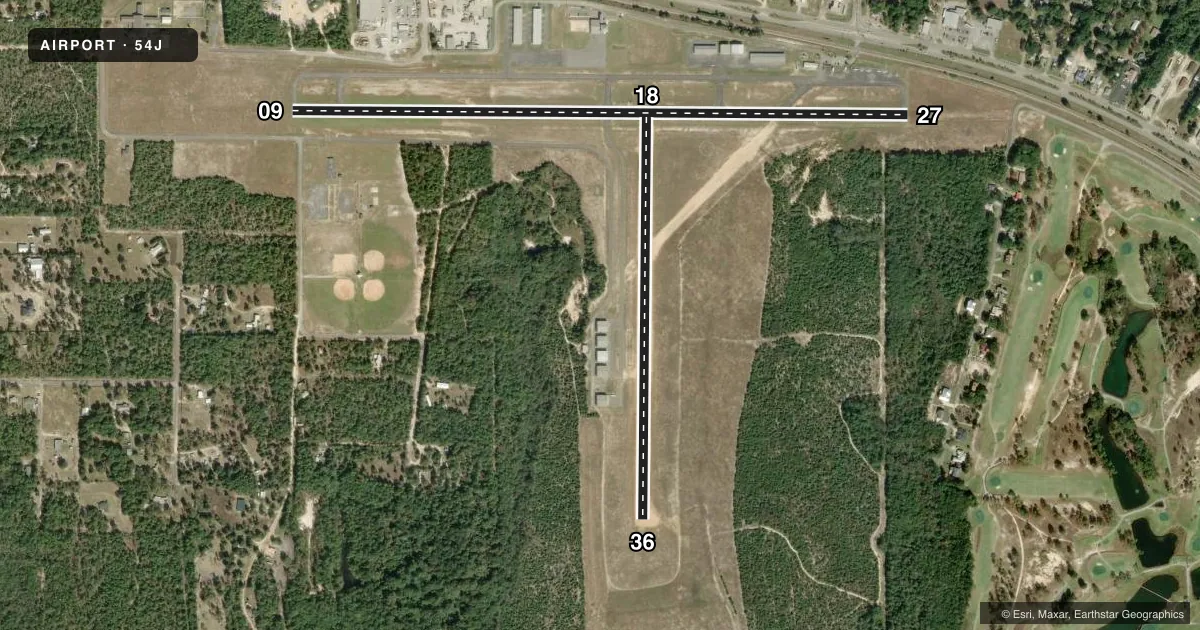
Runways & pattern
Full pagePattern entry · RWY 36
LEFT TRAFFIC| Runway | Heading (°M) | Length | Surface | Traffic |
|---|---|---|---|---|
| 09/27 | 86° / 266° | 4,146 ft | ASPH | Standard L |
| 18/36Favored | 177° / 357° | 2,700 ft | DIRT | Standard L |
Runway end performance
| End | TORA | TODA | ASDA | LDA | VGSI | Approach lights | Obstruction |
|---|---|---|---|---|---|---|---|
| 09 | — | — | — | — | PAPI 2-box left(3°) | — | 6', fence, 200' from thr, 165' R of cntrln, slope 0 |
| 27 | — | — | — | — | PAPI 2-box left(3°) | — | 28', rr, 475' from thr, 250' R of cntrln, slope 9 |
| 18 | — | — | — | — | — | — | 34', pline, 933' from thr, 75' R of cntrln, slope 28 |
| 36 | — | — | — | — | — | — | 26', trees, 1280' from thr, 105' R of cntrln, slope 50 |
Declared distances in feet. TORA = takeoff run available, TODA = takeoff distance, ASDA = accelerate-stop, LDA = landing distance.
Airport sketch
Runways drawn to scale from FAA survey coordinates, rendered over satellite imagery. Not for navigation.
Approaches & charts
Services on the field
Fuel grades, oxygen, maintenance, ramp storage and lighting — as declared to the FAA by the airport operator.
Fuel & services
- Fuel
- 100LLA+
- Oxygen (bottled)
- Not available
- Oxygen (bulk)
- Not available
- Airframe repair
- Major
- Power plant repair
- Major
- Other services
- AMB,AVNCS,INSTR
Ramp & ground
- Transient storage
- Tie-down
- Landing fee
- No fee published
- Customs
- Not available
- Lighting schedule
- SEE RMK
- Beacon schedule
- SS-SR
- Beacon
- White / Green (civil land)(WG)
- Wind indicator
- Lighted
- Segmented circle
- Yes
Fuel & FBOs
Cheapest 100LL and Jet A on the field and nearby. Always confirm with the FBO before taxi.
Airport notes
Surface conditions, obstructions, local procedures, lighting outages and other notes published with each FAA cycle.
General notes
- TREES OBST LN OF SIGHT BTN RWY 09 & 36 AND RWY 27 & 36. RWY 09 & 27 LN OF SIGHT OBST DUE TO RWY 09 UP SLOPE.
- RWY SAFETY AREA E OF RWY 18/36.
Lighting notes
- ACTVT PAPI RWY 9 & 27; MIRL RWY 09/27 - CTAF.
Fuel notes
- 100LLFUEL 24 HR CREDIT CARD SVC AVBL.
Approach & departure obstructions
- 09FENCE 6FT TALL, 200 FT BFR AER, 160 FT RIGHT OF CNTRLN.
- 09UNLGTD FENCE & RD 160 FT S OF CNTRLN PENETRATES APCH SFC.
- 18WHITE PVC PIPE EVERY 200 FT.
- 36WHITE PVC PIPE EVERY 200 FT.
- 09PUBLIC ROAD 15FT TALL, 200 FEET BEFORE AER 185 FT RIGHT OF CENTERLINE.
- 27RWY 27 APCH SLOPE 24:1 TO DTHR.
Other notes
- VFR ONLY.
- OWNERCTC PERSON KOBY TOWNSEND 850-892-8500 FAX: 850-892-6575.
VFR map & nearby airports
VFR sectional. Tap any ICAO chip to open that airport.
Key facts · 54J
Answer card- ICAO
- 54J
- Name
- DEFUNIAK SPRINGS
- Location
- DEFUNIAK SPRINGS, FLORIDA
- Elevation
- 289.1 ft MSL
- Traffic pattern altitude
- 1,289.1 ft MSL (1,000 AGL)
- Control tower
- Non-towered (use CTAF)
- Total runways
- 2
- Longest runway
- 09/27 · 4,146 ft
- Published ILS approaches
- 0
- Published frequencies
- 4
- Magnetic variation
- 4°
- Current flight rules
- VFR
- Current wind
- 360° at 8 kt
- Favored runway now
- RWY 36
DeFuniak Springs Airport sits in DeFuniak Springs, Florida. Field elevation is 289.1 ft MSL. The airport has two runways. The longest is runway 09/27 at 4,146 ft. Runway 18/36 is 2,700 ft of dirt. This is a non-towered field. CTAF and UNICOM are both 123.05. Approach and departure support is on the Eglin frequencies listed in the Chart Supplement. No ILS approaches are published here.
Pattern altitude is not published. Use 1,000 ft AGL for light piston operations unless the current Chart Supplement says otherwise. That puts the traffic pattern at about 1,289 ft MSL based on the field elevation. The airport is VFR only. The published remarks also note 24-hour fuel with credit card service. On the field, DeFuniak Springs Airport carries 100LL and Jet A Prist.
There are a few things to brief before arrival. Runway 09 has a fence and a public road close to the approach end. Runway 27 has a displaced-threshold approach slope note. White PVC markers are placed every 200 feet on runways 18 and 36. PAPI is available on 09 and 27. Medium intensity runway lights are on 09/27 and are controlled by CTAF. Trees also block line of sight between some runway ends, so plan your taxi and runway checks with that in mind.