METAR & TAF 2R4
2R4 does not publish a METAR.
Showing the nearest reporting station: KPNS (PENSACOLA INTL) · 14.0 NM away. Conditions at 2R4 may differ.
METAR · KPNS
Observed 12:53Z
KPNS 271253Z AUTO 30008KT 10SM FEW080 28/24 A2996 RMK AO2 SLP145 T02830239
- Wind
- 300° @ 8 kt
- Visibility
- 10 SM
- Temp / Dew
- 28°C / 24°C
- Altimeter
- 29.96 inHg
- Clouds
- FEW
- Density alt
- 1,612 ft
- Ceiling
- Unlimited
- Rules
- VFR
Airport info & contacts
Manager on record, flight service, ARTCC, attendance schedule and pattern altitude — published by the FAA and refreshed every 28 days.
Location
- From city
- 3 NM E
- VFR sectional
- NEW ORLEANS
- ARTCC
- ZJX · JACKSONVILLE
- NOTAM facility
- GNV (NOTAM-D)
Airport manager
- Name
- JARED LOWE
- Phone
- 850-983-1817
- Address
- 6491 CAROLINE ST, SUITE 4, MILTON FL 32570
Flight service · Hours
- FSS GNV
- GAINESVILLE1-800-WX-BRIEF
- Attendance
- 0700-DUSK
Frequencies
Tap any row to copy the frequency to your clipboard.
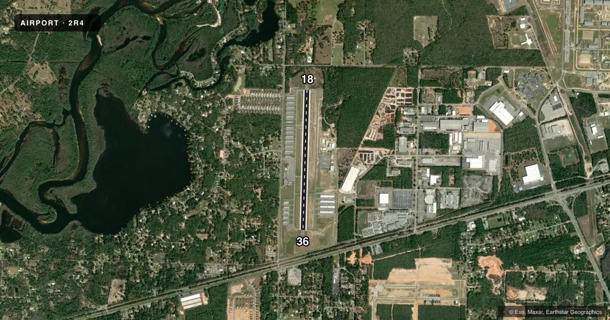
Runways & pattern
Full pagePattern entry · RWY 36
LEFT TRAFFICRunway end performance
| End | TORA | TODA | ASDA | LDA | VGSI | Approach lights | Obstruction |
|---|---|---|---|---|---|---|---|
| 18 | — | — | — | — | — | — | 32', trees, 765' from thr, 200' R of cntrln, slope 17 |
| 36 | — | — | — | — | — | — | 50', trees, 990' from thr, 150' R of cntrln, slope 15 |
Declared distances in feet. TORA = takeoff run available, TODA = takeoff distance, ASDA = accelerate-stop, LDA = landing distance.
Airport sketch
Runways drawn to scale from FAA survey coordinates, rendered over satellite imagery. Not for navigation.
Approaches & charts
Services on the field
Fuel grades, oxygen, maintenance, ramp storage and lighting — as declared to the FAA by the airport operator.
Fuel & services
- Fuel
- 100LLA1+
- Oxygen (bottled)
- Not available
- Oxygen (bulk)
- Not available
- Airframe repair
- Major
- Power plant repair
- Major
- Other services
- INSTR,RNTL
Ramp & ground
- Transient storage
- Tie-down
- Landing fee
- No fee published
- Customs
- Not available
- Lighting schedule
- SEE RMK
- Beacon schedule
- SS-SR
- Beacon
- White / Green (civil land)(WG)
- Wind indicator
- Lighted
- Segmented circle
- Yes
Fuel & FBOs
Cheapest 100LL and Jet A on the field and nearby. Always confirm with the FBO before taxi.
Airport notes
Surface conditions, obstructions, local procedures, lighting outages and other notes published with each FAA cycle.
General notes
- BE ALERT ARPT SITUATED IN CUT-OFF OF NAS WHITING CASS C AIRSPACE LOCATED 1400 FT OVERHEAD WITHIN 1 MILE FROM THE CENTER OF THE ARPT ON THREE SIDES TO THE EAST, NORTH, AND WEST FROM SURFACE TO 4200 FT.
- GCO AVBL ON FREQ 121.725 THRU PENSACOLA APCH.
- INTENSIVE FLIGHT TRAINING INVOF ARPT.
- LIMITED PARKING ON WEST RAMP FOR TRANSIENT ACFT URGED TO BRING TIE-DOWN ROPES FOR EAST RAMP PARKING.
- FOR CD IF UNA VIA GCO CTC JACKSONVILLE ARTCC AT 904-845-1592.
- LNDG AND TKOFS IN THE GRASS ARE AT YOUR OWN RISK.
Lighting notes
- ACTVT REIL RY 18 & 36; MIRL RY 18/36 - CTAF.
Fuel notes
- 100LLFUEL 24 HR CREDIT CARD SVC AVBL.
Approach & departure obstructions
- 18RWY 18 MRKGS DISCOLORED AND FADED.
- 36RWY 36 MRKGS DISCOLORED AND FADED.
- 18APCH SLOPE 24:1 TO AER.
Other notes
- VFR OPERATIONS ONLY.
- AUTOMATED UNICOM
- MANAGERAIRPORT PHYSICAL ADDRESS: 5550 NORTH AIRPORT RD.
- MANAGERALT CTC: TONY HOWARD - TONYH@SANTAROSA.FL.GOV
- OWNERCTC PERSON: BRAD BAKER
VFR map & nearby airports
VFR sectional. Tap any ICAO chip to open that airport.
Key facts · 2R4
Answer card- ICAO
- 2R4
- Name
- PETER PRINCE FLD
- Location
- MILTON, FLORIDA
- Elevation
- 81.7 ft MSL
- Traffic pattern altitude
- 1,081.7 ft MSL (1,000 AGL)
- Control tower
- Non-towered (use CTAF)
- Total runways
- 1
- Longest runway
- 18/36 · 3,703 ft
- Published ILS approaches
- 0
- Published frequencies
- 4
- Magnetic variation
- 1°
- Current flight rules
- VFR
- Current wind
- 300° at 8 kt
- Favored runway now
- RWY 36
Peter Prince Fld (2R4) sits in Milton, Florida. The field elevation is 81.7 ft MSL. It has one runway. Runway 18/36 is 3,703 ft of asphalt. The airport is non-towered. Pattern altitude is not published, so use the standard 1,000 ft AGL for light piston traffic unless the current Chart Supplement says otherwise.
No ILS approaches are published here. This is a VFR-only field. The airport sits in a cut-off of NAS Whiting Class C airspace that reaches overhead and wraps close to the field on the east, north and west sides. That makes local situational awareness important, especially if you are arriving or departing near the edges of the airspace shelf. Intensive flight training is also in the area. Expect busy pattern work.
Peter Prince Aviation Center is on the field. It carries 100LL. Fuel is available 24 hours with credit card service. Runway 36 markings are faded, so brief the runway carefully before landing. Parking is limited on the west ramp. Bring tie-down ropes if you plan to use the east ramp. The airport also notes that grass operations are at your own risk.