METAR & TAF KGZH
Current METAR
Observed 12:53Z
KGZH 271253Z AUTO 00000KT 10SM CLR 28/24 A2997 RMK AO2 SLP144 T02780244
- Wind
- 000° @ 0 kt
- Visibility
- 10 SM
- Temp / Dew
- 28°C / 24°C
- Altimeter
- 29.97 inHg
- Clouds
- CLR
- Density alt
- 1,819 ft
- Ceiling
- Unlimited
- Rules
- VFR
Airport info & contacts
Manager on record, flight service, ARTCC, attendance schedule and pattern altitude — published by the FAA and refreshed every 28 days.
Location
- From city
- 5 NM W
- VFR sectional
- NEW ORLEANS
- ARTCC
- ZJX · JACKSONVILLE
- NOTAM facility
- GZH (NOTAM-D)
Airport manager
- Name
- BRIAN MARTIN
- Phone
- 251-369-2448
- Address
- 14134 US HWY 84 WEST, EVERGREEN AL 36401
Flight service · Hours
- FSS ANB
- ANNISTON1-800-WX-BRIEF
- Attendance
- MON-FRI · 0800-1700
Frequencies
Tap any row to copy the frequency to your clipboard.
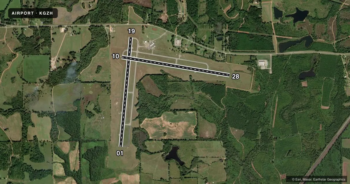
Runways & pattern
Full pagePattern entry · RWY 01
LEFT TRAFFIC| Runway | Heading (°M) | Length | Surface | Traffic |
|---|---|---|---|---|
| 01/19 | 2° / 182° | 5,005 ft | ASPH | Standard L |
| 10/28 | 97° / 277° | 5,004 ft | ASPH | Standard L |
Runway end performance
| End | TORA | TODA | ASDA | LDA | VGSI | Approach lights | Obstruction |
|---|---|---|---|---|---|---|---|
| 01 | — | — | — | — | — | — | 41', tree, 1054' from thr, 368' R of cntrln, slope 20 |
| 19 | — | — | — | — | — | — | 77', tree, 1323' from thr, 402' R of cntrln, slope 14 |
| 10 | — | — | — | — | PAPI 4-box left(3°) | — | 45', tree, 1095' from thr, 116' R of cntrln, slope 19 |
| 28 | — | — | — | — | — | — | 62', tree, 1438' from thr, 181' R of cntrln, slope 19 |
Declared distances in feet. TORA = takeoff run available, TODA = takeoff distance, ASDA = accelerate-stop, LDA = landing distance.
Airport sketch
Runways drawn to scale from FAA survey coordinates, rendered over satellite imagery. Not for navigation.
Approaches & charts
Services on the field
Fuel grades, oxygen, maintenance, ramp storage and lighting — as declared to the FAA by the airport operator.
Fuel & services
- Fuel
- 100LLA+
- Oxygen (bottled)
- Not available
- Oxygen (bulk)
- Not available
Ramp & ground
- Transient storage
- Tie-down
- Hangar
- Landing fee
- Yes
- Customs
- Not available
- Lighting schedule
- SEE RMK
- Beacon schedule
- SS-SR
- Beacon
- White / Green (civil land)(WG)
- Wind indicator
- Yes
- Segmented circle
- No
Fuel & FBOs
Cheapest 100LL and Jet A on the field and nearby. Always confirm with the FBO before taxi.
Airport notes
Surface conditions, obstructions, local procedures, lighting outages and other notes published with each FAA cycle.
General notes
- INTENSIVE NAVY PROP TRNG MON-FRI SR-SS.
- DIST MKRS ON BOTH SIDES OF RWYS 10/28 & 01/19 ARE US NAVY EQUIP.
- MILITARY: MISC: TRAILER MANNED BY USN RWY DUTY OFFICER WHEN A110-01 ACTIVE. PERM USN CRASH CREW.
- FOR CD CTC JACKSONVILLE ARTCC AT 904-845-1592.
- FOR AFT HRS SVC CALL 251-369-2091.
- MILITARY: MISC: OPR 1400-2300Z++ MON-FRI. (MIL OPR 1245-2230Z++ MON-FRI; 1430-2300Z++ SAT.
Lighting notes
- ACTVT PAPI RWY 10; MIRL RWYS 01/19 & 10/28 - CTAF.
Approach & departure obstructions
- 01MARKINGS FADED.
- 10MARKINGS FADED.
- 19MARKINGS FADED.
- 28MARKINGS FADED.
Other notes
- EXISTED PRIOR TO FAA ACT.
VFR map & nearby airports
VFR sectional. Tap any ICAO chip to open that airport.
Key facts · KGZH
Answer card- ICAO
- KGZH
- Name
- EVERGREEN RGNL/MIDDLETON FLD
- Location
- EVERGREEN, ALABAMA
- Elevation
- 259 ft MSL
- Traffic pattern altitude
- 1,259 ft MSL (1,000 AGL)
- Control tower
- Non-towered (use CTAF)
- Total runways
- 2
- Longest runway
- 01/19 · 5,005 ft
- Published ILS approaches
- 0
- Published frequencies
- 2
- Magnetic variation
- 3°
- Current flight rules
- VFR
- Current wind
- 000° at 0 kt
- Favored runway now
- –
Evergreen Rgnl/Middleton Fld sits in Evergreen, Alabama. Field elevation is 259 ft MSL. The airport has two asphalt runways. The longest is runway 01/19 at 5,005 ft. There is no control tower, so plan to self-announce on CTAF 122.7. No ILS approaches are published here. Pattern altitude is not published. Use 1,000 ft AGL for light piston ops unless the current Chart Supplement says otherwise.
Evergreen Regional Airport is the on-field FBO. It carries 100LL and Jet A Prist. Call (251) 578-1274 for current service details. Published remarks show faded markings on all four runway ends. Runway 10 has an active PAPI. Medium intensity runway lights are on both runways. Use CTAF for lighting. There are also Navy-related operations here. That includes intensive propeller training on weekdays and military activity during published Zulu windows. That means a careful listen on the radio is smart before joining the pattern.
For clearance delivery, contact Jacksonville ARTCC at 904-845-1592. If you are flying in after hours, the published remarks list a separate service number. Check the current FAA Chart Supplement before departure for any changes to operations or local procedures.