METAR & TAF 12J
12J does not publish a METAR.
Showing the nearest reporting station: KGZH (EVERGREEN RGNL/MIDDLETON FLD) · 21.9 NM away. Conditions at 12J may differ.
METAR · KGZH
Observed 14:53Z
KGZH 271453Z AUTO VRB04KT 10SM SCT041 BKN050 BKN065 29/24 A2997 RMK AO2 SLP145 T02940244 50006
- Wind
- VAR @ 4 kt
- Visibility
- 10 SM
- Temp / Dew
- 29°C / 24°C
- Altimeter
- 29.97 inHg
- Clouds
- BKN
- Density alt
- 1,741 ft
- Ceiling
- 5,000 ft AGL
- Rules
- VFR
Airport info & contacts
Manager on record, flight service, ARTCC, attendance schedule and pattern altitude — published by the FAA and refreshed every 28 days.
Location
- From city
- 3 NM S
- VFR sectional
- NEW ORLEANS
- ARTCC
- ZJX · JACKSONVILLE
- NOTAM facility
- ANB (NOTAM-D)
Airport manager
- Name
- MONTE MCGOUGHIN
- Phone
- 251-363-1551
- Address
- 111 DOGWOOD LANE W., BREWTON AL 36426
Flight service · Hours
- FSS ANB
- ANNISTON1-800-WX-BRIEF
- Attendance
- MON-FRI · 0730-1700
- SAT · 0830-1700
Frequencies
Tap any row to copy the frequency to your clipboard.
Runways & pattern
Full pagePattern entry · RWY 30
LEFT TRAFFIC| Runway | Heading (°M) | Length | Surface | Traffic |
|---|---|---|---|---|
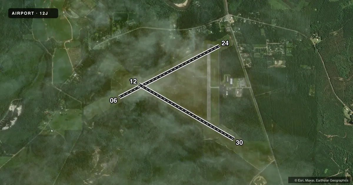
| 06/24 | 62° / 242° | 5,136 ft | ASPH | Standard L |
| 12/30Favored | 119° / 299° | 5,001 ft | ASPH | Standard L |
Runway end performance
| End | TORA | TODA | ASDA | LDA | VGSI | Approach lights | Obstruction |
|---|---|---|---|---|---|---|---|
| 06 | — | — | — | — | — | — | 10', tree, 245' from thr, 48' R of cntrln, slope 4 |
| 24 | — | — | — | — | — | — | 97', trees, 1308' from thr, 92' R of cntrln, slope 11 |
| 12 | — | — | — | — | PAPI 2-box left(3.25°) | — | 90', trees, 1913' from thr, 138' R of cntrln, slope 19 |
| 30 | — | — | — | — | PAPI 2-box left(3.5°) | — | — |
Declared distances in feet. TORA = takeoff run available, TODA = takeoff distance, ASDA = accelerate-stop, LDA = landing distance.
Airport sketch
Runways drawn to scale from FAA survey coordinates, rendered over satellite imagery. Not for navigation.
Approaches & charts
Services on the field
Fuel grades, oxygen, maintenance, ramp storage and lighting — as declared to the FAA by the airport operator.
Fuel & services
- Fuel
- 100LLA+
- Oxygen (bottled)
- Not available
- Oxygen (bulk)
- Not available
- Airframe repair
- Major
- Power plant repair
- Major
- Other services
- INSTR,RNTL
Ramp & ground
- Transient storage
- Tie-down
- Hangar
- Landing fee
- No fee published
- Customs
- Not available
- Lighting schedule
- SEE RMK
- Beacon schedule
- SS-SR
- Beacon
- White / Green (civil land)(WG)
- Wind indicator
- Lighted
- Segmented circle
- No
Fuel & FBOs
Cheapest 100LL and Jet A on the field and nearby. Always confirm with the FBO before taxi.
Airport notes
Surface conditions, obstructions, local procedures, lighting outages and other notes published with each FAA cycle.
General notes
- USN PILOT TRNG FM WHITING FLD.
- FOR CD CTC PENSACOLA APCH AT 850-266-6884 OR 850-266-6885.
- MILITARY: MISC: OPR 1245-2230Z++ MON - FRI; SAT - SUN AS RQRD; CLSD HOL. MIL TRNG ACFT MNT UNICOM AND YIELD TO ALL CIV OPR. VFR TFC RQR TO STAY AT OR BLW 1000 FT AGL ON APCH TO ARPT. MIL ACFT RRQ PRIOR COORD WITH NAS WHITING FLD, DSN 868-7475, C850-623-7475.
- AFTER HR FONE C251-867-9997. (MIL OPR 1300-1245Z++ MON-FRI; OT O/R)
Lighting notes
- ACTVT PAPI RWY 12 & 30; MIRL RWY 12/30 - CTAF.
Approach & departure obstructions
- 30BRUSH LCTD 79 FT FM RWY END, 91 FT LEFT OF CNTLN.
- 06MARKINGS FADED, CNTLN OBSCURED.
- 12MARKINGS FADED, CNTLN OBSCURED.
- 24MARKINGS FADED, CNTLN OBSCURED.
- 30MARKINGS FADED, CNTLN OBSCURED.
- 12FIXED DISTANCE MARKER 500 FT FM RWY END.
- 30FIXED DISTANCE MARKER 500 FT FM RWY END.
- 12UNUSBL BYD 6 DEG LEFT OF CNTRLN.
Other notes
- PRIOR TO FAA ACT
- 1AFT HRS CALL 251-867-9997.
- 12/30SFC EXPERIENCING EXTSV CRACKING.
VFR map & nearby airports
VFR sectional. Tap any ICAO chip to open that airport.
Key facts · 12J
Answer card- ICAO
- 12J
- Name
- BREWTON MUNI
- Location
- BREWTON, ALABAMA
- Elevation
- 98.8 ft MSL
- Traffic pattern altitude
- 1,098.8 ft MSL (1,000 AGL)
- Control tower
- Non-towered (use CTAF)
- Total runways
- 2
- Longest runway
- 06/24 · 5,136 ft
- Published ILS approaches
- 0
- Published frequencies
- 4
- Magnetic variation
- 1°
- Current flight rules
- VFR
- Current wind
- 000° at 4 kt
- Favored runway now
- RWY 30
Brewton Muni sits in Brewton, Alabama. Field elevation is 98.8 ft MSL. The airport has two asphalt runways. The longest is runway 06/24 at 5,136 ft. Runway 12/30 is 5,001 ft. There is no control tower. CTAF and UNICOM are both 122.725. No ILS approaches are published here.
Pattern altitude is not published. Use the standard 1,000 ft AGL pattern for light piston traffic unless the current FAA Chart Supplement says otherwise. The field is served by Aviation Specialists on the field. They carry 100LL and Jet A. Call ahead at (251) 867-9997 if you need current ramp or fuel availability.
The remarks matter here. Runway 12/30 has extensive cracking. Runway 12, runway 24 and runway 06 have faded markings with obscured centerlines. PAPI is available on runways 12 and 30. Medium intensity runway lights on 12/30 are controlled by CTAF. There is also Navy training activity from Whiting Field. Military traffic monitors UNICOM. Civilian traffic has priority. VFR traffic is required to stay at or below 1,000 ft AGL on approach to the airport. Brush sits close to the departure end of runway 30. If you are planning a first visit, brief the runway condition, the mixed civilian and military traffic and the lack of published ILS before you go.