METAR & TAF KPNS
Current METAR
Observed 12:53Z
KPNS 271253Z AUTO 30008KT 10SM FEW080 28/24 A2996 RMK AO2 SLP145 T02830239
- Wind
- 300° @ 8 kt
- Visibility
- 10 SM
- Temp / Dew
- 28°C / 24°C
- Altimeter
- 29.96 inHg
- Clouds
- FEW
- Density alt
- 1,660 ft
- Ceiling
- Unlimited
- Rules
- VFR
Airport info & contacts
Manager on record, flight service, ARTCC, attendance schedule and pattern altitude — published by the FAA and refreshed every 28 days.
Location
- From city
- 3 NM NE
- VFR sectional
- NEW ORLEANS
- ARTCC
- ZJX · JACKSONVILLE
- NOTAM facility
- PNS (NOTAM-D)
Airport manager
- Name
- MATT COUGHLIN, C.M.
- Phone
- 850-436-5000
- Address
- 2430 AIRPORT BLVD SUITE 225, PENSACOLA FL 32504
Flight service · Hours
- FSS GNV
- GAINESVILLE1-800-WX-BRIEF
- Attendance
- ALL
Frequencies
Tap any row to copy the frequency to your clipboard.
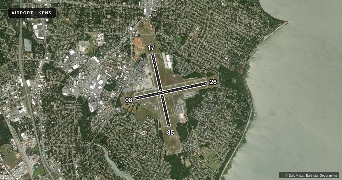
Runways & pattern
Full pagePattern entry · RWY 26
LEFT TRAFFIC| Runway | Heading (°M) | Length | Surface | Traffic |
|---|---|---|---|---|
| 17/35 | 165° / 345° | 7,004 ft | CONC | Standard L |
| 08/26Favored | 76° / 256° | 7,000 ft | ASPH | Standard L |
Runway end performance
| End | TORA | TODA | ASDA | LDA | VGSI | Approach lights | Obstruction |
|---|---|---|---|---|---|---|---|
| 17 | — | — | — | — | PAPI 4-box left(3°) | MALSR | 86', pline, 4390' from thr, 500' R of cntrln, slope 48 |
| 35 | — | — | — | — | PAPI 4-box left(3°) | — | — |
| 08 | — | — | — | — | PAPI 4-box left(3°) | — | 29', trees, 1365' from thr, 410' R of cntrln, slope 40 |
| 26 | — | — | — | — | PAPI 4-box left(3°) | — | 43', trees, 1690' from thr, 355' R of cntrln, slope 34 |
Declared distances in feet. TORA = takeoff run available, TODA = takeoff distance, ASDA = accelerate-stop, LDA = landing distance.
Airport sketch
Runways drawn to scale from FAA survey coordinates, rendered over satellite imagery. Not for navigation.
Approaches & charts
ILS · 2
Services on the field
Fuel grades, oxygen, maintenance, ramp storage and lighting — as declared to the FAA by the airport operator.
Fuel & services
- Fuel
- 100100LLA
- Oxygen (bottled)
- Not available
- Oxygen (bulk)
- High pressure
- Airframe repair
- Major
- Power plant repair
- Major
- Other services
- CHTR,INSTR,RNTL,SALES
Ramp & ground
- Transient storage
- Tie-down
- Hangar
- Landing fee
- No fee published
- Customs
- Not available
- Lighting schedule
- SEE RMK
- Beacon schedule
- SS-SR
- Beacon
- White / Green (civil land)(WG)
- Wind indicator
- Lighted
- Segmented circle
- Yes
Fuel & FBOs
Cheapest 100LL and Jet A on the field and nearby. Always confirm with the FBO before taxi.
Airport notes
Surface conditions, obstructions, local procedures, lighting outages and other notes published with each FAA cycle.
General notes
- TBJT WITH MAX TKOF WT OVR 75000 LBS EXCT STD NOISE ABATEMENT DEP PROFILE IAW FAA AC 91-53.
- FIXED WING VFR DEP PROCD TO ARPT BDRY BFR TURNING UNLESS DRCTD BY ATC.
- HELICOPTER LNDG CTC PENSACOLA AVN 850-434-0636. HELICOPTER PARKING IS LOCATED W OF PENSACOLA AVN RAMP.
- TWY C SOUTH OF RWY 8/26, C1, C2, TWY D EAST OF RWY 17/35, D1, D2, D3, D4, & D5 ARE 35 FT WIDE; CLSD TO ACFT WITH A WINGSPAN MORE THAN 79 FT.
- RUN-UP PAD FOR PISTON ACFT LCTD ON TWY D BTWN D1 & C; FACE NOSE OF ACFT S; OTR ACFT RUN-UP INFO - AMGR.
- CTN: RWY 08 APCHS MAY MISTAKE SAUFLEY FIELD NOLF LCTD 7 MI W FOR PNS.
- FOR CD IF UNA TO CTC ON FSS FREQ, CTC PENSACOLA APCH AT 850-266-6884 OR 850-266-6885.
- NEW APRON SOUTH OF U.S. CUSTOMS AND BORDER PROTECTION (CBP) TEMPORARILY CLSD EXC FOR ACFT BEING PROCESSED BY CBP.
- 24 HR ADVN NOTICE OR IMT REPORTING UPON LDG FOR ACFT EQUIPPED WITH WEATHER MODIFICATION OR GEOENGINEERING EQUIP.
- BIRDS ON & INVOF ARPT.
Lighting notes
- WHEN ATCT CLSD, ACTVT MALSR RWY 17; TDZ RWY 17; HIRL RWY 17/35, 08/26 - CTAF.
Runway surface & condition
- 08/26FDOT AVN OFC STATEWIDE PCR DVLPMT PROGRAM SEPTEMBER 2024.
- 08/26PCR VALUE: 780/F/A/X/T
- 17/35PCR VALUE: 930/R/B/W/T
Approach & departure obstructions
- 08405 FT TREES R OF CNTRLN 200 FT BFR AER.
- 08PREFERRED DEP RWY.
- 26BLACK HOLE ILLUSION EXISTS DURG NGT APCH.
- 174275 FT TWR 900 FT L EL 204.
Other notes
- PPR 24HRS IN ADVN FOR UNSKED AIR CARRIER OPS WITH MORE THAN 30 PAX SEATS OR FOR ANY UNSKED ACFT EXCEEDING 65,000LBS GWT AND/OR WINGSPAN GREATER THAN 79 FT, ANY TILT-ROTOR ACFT AND/OR HELS WITH A ROTOR DIAMETER GREATER THAN 79 FT CALL (850) 436-5000.
- FLT NTFN SVC (ADCUS) AVBL.
- OVHD 1500 FT.
VFR map & nearby airports
VFR sectional. Tap any ICAO chip to open that airport.
Key facts · KPNS
Answer card- ICAO
- KPNS
- Name
- PENSACOLA INTL
- Location
- PENSACOLA, FLORIDA
- Elevation
- 120.9 ft MSL
- Traffic pattern altitude
- 1,120.9 ft MSL (1,000 AGL)
- Control tower
- Towered · 0530-2300
- Total runways
- 2
- Longest runway
- 17/35 · 7,004 ft
- Published ILS approaches
- 2
- Published frequencies
- 28
- Magnetic variation
- 2°
- Current flight rules
- VFR
- Current wind
- 300° at 8 kt
- Favored runway now
- RWY 26
Pensacola Intl is in Pensacola, Florida. Field elevation is 120.9 ft MSL. The airport has 2 runways. The longest is 7,004 ft on runway 17/35. The tower is open 0530-2300. KPNS has ILS approaches to runway ends 17 and 26. The published traffic pattern altitude is overhead 1,500 ft MSL. For light piston traffic, that works out to about 1,000 ft AGL based on the field elevation.
On the field, Pensacola Aviation Center carries 100LL, Jet A and Jet A Prist. Innisfree Jet Center also carries 100LL, Jet A and Jet A Prist. If you are planning a helicopter arrival, the published remarks say to contact Pensacola Aviation first. Helicopter parking is west of the Pensacola Aviation ramp.
A few local items matter here. Birds are reported on and near the airport. Runway 08 has trees close in on the right side before the threshold. Runway 17 has a tall tower left of centerline. Fixed wing VFR departures are published to continue to the airport boundary before turning unless ATC says otherwise. Runway 08 approaches can be confused with Saufley Field Naval Outlying Landing Field, which is 7 miles west. The field is in Class C airspace. Plan to work the tower and approach control as published.