METAR & TAF KCEW
Current METAR
Observed 15:53Z
KCEW 271553Z AUTO 33009KT 9SM CLR 33/24 A2997 RMK AO2 SLP145 T03330244
- Wind
- 330° @ 9 kt
- Visibility
- 9 SM
- Temp / Dew
- 33°C / 24°C
- Altimeter
- 29.97 inHg
- Clouds
- CLR
- Density alt
- 2,363 ft
- Ceiling
- Unlimited
- Rules
- VFR
Airport info & contacts
Manager on record, flight service, ARTCC, attendance schedule and pattern altitude — published by the FAA and refreshed every 28 days.
Location
- From city
- 3 NM NE
- VFR sectional
- NEW ORLEANS
- ARTCC
- ZJX · JACKSONVILLE
- NOTAM facility
- CEW (NOTAM-D)
Airport manager
- Name
- TRACY STAGE
- Phone
- 850-651-7160
- Address
- 1701 STATE ROAD 85 NORTH, EGLIN AFB FL 32542-1413
Flight service · Hours
- FSS GNV
- GAINESVILLE1-800-WX-BRIEF
- Attendance
- 0600-2000
Frequencies
Tap any row to copy the frequency to your clipboard.
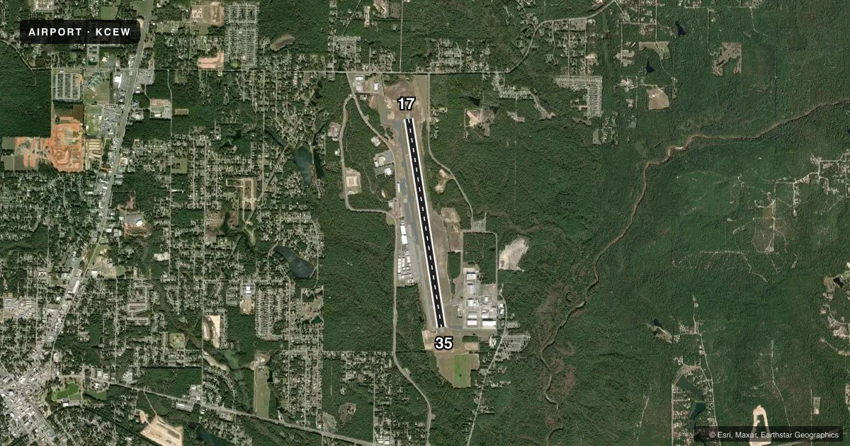
Runways & pattern
Full pagePattern entry · RWY 35
LEFT TRAFFICRunway end performance
| End | TORA | TODA | ASDA | LDA | VGSI | Approach lights | Obstruction |
|---|---|---|---|---|---|---|---|
| 17 | — | — | — | — | PAPI 4-box right(3°) | — | 41', trees, 1845' from thr, 95' R of cntrln, slope 40 |
| 35 | — | — | — | — | PAPI 4-box right(3°) | — | 58', trees, 2195' from thr, 120' R of cntrln, slope 34 |
Declared distances in feet. TORA = takeoff run available, TODA = takeoff distance, ASDA = accelerate-stop, LDA = landing distance.
Airport sketch
Runways drawn to scale from FAA survey coordinates, rendered over satellite imagery. Not for navigation.
Approaches & charts
ILS · 1
Services on the field
Fuel grades, oxygen, maintenance, ramp storage and lighting — as declared to the FAA by the airport operator.
Fuel & services
- Fuel
- 100LLAA1+
- Oxygen (bottled)
- High pressure
- Oxygen (bulk)
- High pressure
- Airframe repair
- Major
- Power plant repair
- Major
- Other services
- CHTR,INSTR,RNTL
Ramp & ground
- Transient storage
- Tie-down
- Landing fee
- No fee published
- Customs
- Not available
- Lighting schedule
- SEE RMK
- Beacon schedule
- SS-SR
- Beacon
- White / Green (civil land)(WG)
- Wind indicator
- Lighted
Fuel & FBOs
Cheapest 100LL and Jet A on the field and nearby. Always confirm with the FBO before taxi.
Airport notes
Surface conditions, obstructions, local procedures, lighting outages and other notes published with each FAA cycle.
General notes
- MIL & TRNG TFC ALL QUADRANTS; MEN & EQUIP ON & INVOF SAFETY AREA.
- NOISE ABATEMENT PROC IN EFCT; DEP MNTN RWY HDG TO 700 FT MSL BFR TURNING.
- WILDLIFE ON & INVOF ARPT; SPCLY AT NIGHT.
- FOR CD IF UNA TO CTC ON FSS FREQ, CTC EGLIN APCH 850-882-9152 OR 850-882-9151.
- VFR ARR MNT 122.95.
Lighting notes
- ACTVT HIRL RWY 17/35 - CTAF. PAPI RWYS 17 & 35 OPER CONSLY.
Fuel notes
- 100LLFOR FUEL AFT 1900 CALL 850-393-0751.
Approach & departure obstructions
- 17UNLGT OBST IN APCH; 55 FT TREES 1755 FT BFR AER.
Other notes
- MANAGERARPT PHYSICAL ADDR: 5545 JOHN GIVENS ROAD, CRESTVIEW, FL 32536.
- MANAGERALT CTC: NICHOLAS WISNOSKI - (850) 333-7730
- MANAGEREXT 4.
- OWNERFAX: 850-651-7164
VFR map & nearby airports
VFR sectional. Tap any ICAO chip to open that airport.
Key facts · KCEW
Answer card- ICAO
- KCEW
- Name
- BOB SIKES
- Location
- CRESTVIEW, FLORIDA
- Elevation
- 213.5 ft MSL
- Traffic pattern altitude
- 1,213.5 ft MSL (1,000 AGL)
- Control tower
- Non-towered (use CTAF)
- Total runways
- 1
- Longest runway
- 17/35 · 8,006 ft
- Published ILS approaches
- 1
- Published frequencies
- 4
- Magnetic variation
- 4°
- Current flight rules
- VFR
- Current wind
- 330° at 9 kt
- Favored runway now
- RWY 35
Bob Sikes Airport is in Crestview, Florida. The field elevation is 213.5 ft MSL. It has one runway, 17/35, which is 8,006 ft long. There is no control tower. The airport has one ILS approach. It is for runway 17. Pattern altitude is not published, so use 1,000 ft AGL for light piston aircraft unless current local guidance says otherwise.
Emerald Coast Aviation is on the field. It carries AVGAS 100LL, Jet A and Jet A Prist. If you need fuel after 1900, call ahead before you launch. The runway lighting is high intensity on 17/35. It is activated by the CTAF. The precision approach path indicators on runways 17 and 35 operate continuously.
This is a busy military area. Training traffic can be in all quadrants. Men and equipment may be on or near the safety area. There is also an unlighted obstruction in the approach. The published remarks call out 55 ft trees 1,755 ft before the airport. Noise abatement is in effect. Depart runway heading to 700 ft MSL before turning. Wildlife is also a factor, especially at night. For clearance delivery if you cannot reach flight service, contact Eglin Approach. Use the current Chart Supplement for any updated operating notes before you go.