METAR & TAF KJKA
Current METAR
Observed 15:55Z
KJKA 271555Z 30011G17KT 10SM CLR 34/24 A2995
- Wind
- 300° @ 11G17 kt
- Visibility
- 10 SM
- Temp / Dew
- 34°C / 24°C
- Altimeter
- 29.95 inHg
- Clouds
- CLR
- Density alt
- 2,264 ft
- Ceiling
- Unlimited
- Rules
- VFR
Airport info & contacts
Manager on record, flight service, ARTCC, attendance schedule and pattern altitude — published by the FAA and refreshed every 28 days.
Location
- From city
- 2 NM N
- VFR sectional
- NEW ORLEANS
- ARTCC
- ZJX · JACKSONVILLE
- NOTAM facility
- ANB (NOTAM-D)
Airport manager
- Name
- JESSE FOSNAUGH
- Phone
- 251-967-3968
- Address
- PO BOX 919, GULF SHORES AL 36547
Flight service · Hours
- FSS ANB
- ANNISTON1-800-WX-BRIEF
- Attendance
- 0600-2200
Frequencies
Tap any row to copy the frequency to your clipboard.
Runways & pattern
Full pagePattern entry · RWY 27
LEFT TRAFFIC| Runway | Heading (°M) | Length | Surface | Traffic |
|---|---|---|---|---|
| 09/27Favored | 90° / 270° | 6,962 ft | ASPH | Standard L |
| 17/35 | 175° / 355° | 3,596 ft | ASPH | Standard L |
Runway end performance
| End | TORA | TODA | ASDA | LDA | VGSI | Approach lights | Obstruction |
|---|---|---|---|---|---|---|---|
| 09 | 6,962' | 6,962' | 6,962' | 6,500' | PAPI 4-box left(3°) | — | 84', trees, 2039' from thr, 140' R of cntrln, slope 21 |
| 27 | 6,500' | 6,500' | 6,500' | 6,500' | PAPI 4-box left(3°) | MALSR | — |
| 17 | 3,276' | 3,276' | 3,276' | 3,276' | PAPI 2-box left(3.63°) | — | 148', trees, 1427' from thr, 234' R of cntrln, slope 8 |
| 35 | 3,596' | 3,596' | 3,596' | 3,276' | PAPI 2-box left(4°) | — | 53', tree, 436' from thr, 212' R of cntrln, slope 4 |
Declared distances in feet. TORA = takeoff run available, TODA = takeoff distance, ASDA = accelerate-stop, LDA = landing distance.
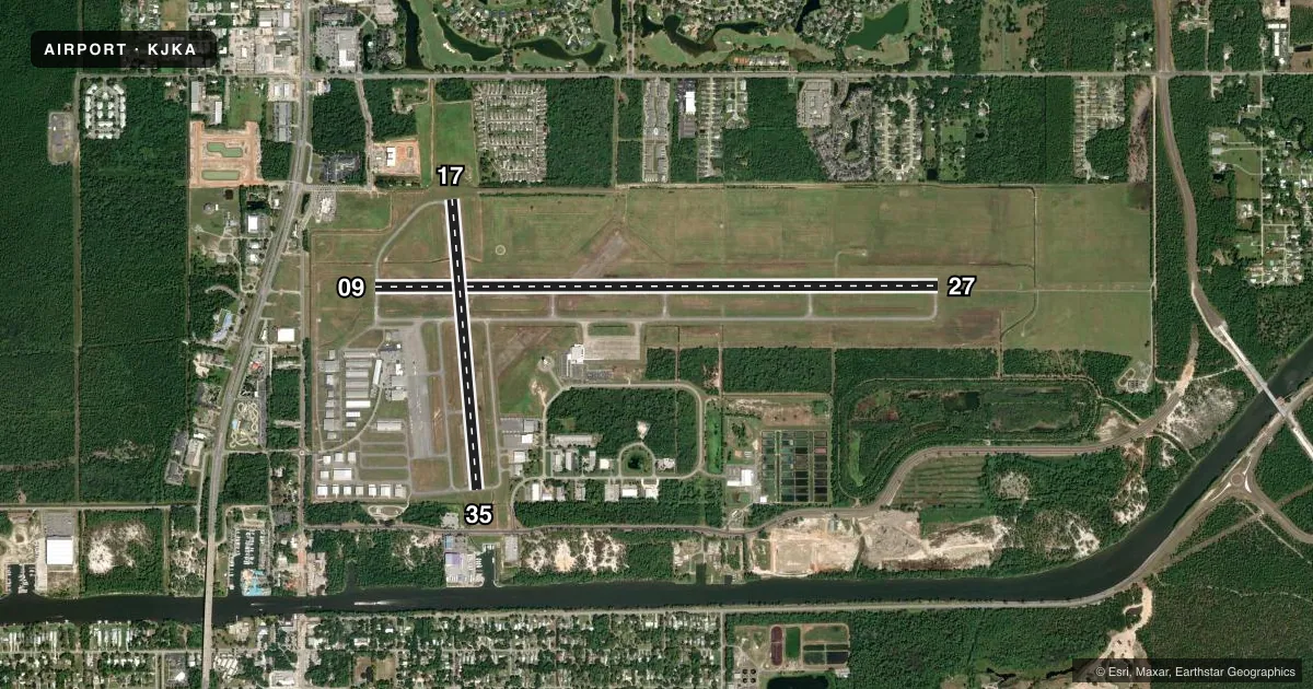
Airport sketch
Runways drawn to scale from FAA survey coordinates, rendered over satellite imagery. Not for navigation.
Approaches & charts
ILS · 1
Services on the field
Fuel grades, oxygen, maintenance, ramp storage and lighting — as declared to the FAA by the airport operator.
Fuel & services
- Fuel
- 100LLA+
- Oxygen (bottled)
- High pressure
- Oxygen (bulk)
- High pressure
- Airframe repair
- Major
- Power plant repair
- Major
- Other services
- CARGO,CHTR,INSTR,RNTL,SALES
Ramp & ground
- Transient storage
- Tie-down
- Hangar
- Landing fee
- No fee published
- Customs
- Not available
- Lighting schedule
- SEE RMK
- Beacon schedule
- SS-SR
- Beacon
- White / Green (civil land)(WG)
- Wind indicator
- Lighted
- Segmented circle
- Yes
Fuel & FBOs
Cheapest 100LL and Jet A on the field and nearby. Always confirm with the FBO before taxi.
Airport notes
Surface conditions, obstructions, local procedures, lighting outages and other notes published with each FAA cycle.
General notes
- EXTSV BANNER TOWING, HEL AND PARA-SAIL OPS ALONG COASTLINE 15 NM MILES W TO 20 NM E OF GULF SHORES/ORANGE BEACH, AND 15 NM WSW TO 20 NM ESE OF JKA.
- CAUTION: HOP AT OR BLW 300 FT MSL WI 1 NM OF JKA WHEN LNDG/DEP HELIPAD LCTD 1.6 NM E, DIRECTLY UNDER RWY 27 FINAL. NOLF BARIN LCTD 6 MILES NE OF AP MAY BE MISTAKEN FOR JACK EDWARDS NTL AP. HI VOL OF MIL TFC WILL BE OPRG IN THE BARIN FIELD TFC PAT FROM SFC TO 3000 FT AGL.
- FREQ 122.7 FOR UNICOM USE ONLY.
- ACR OPNS INVOLVING ACFT WITH MORE THAN 9 PAX SEATS ARE NA IN EXCESS OF 15 MINS BFR OR AFT SKED ARR OR DEP TIMES WO PRIOR CDN WITH ARPT MGMT OR THE ARPT SAFETY DEPT AND CFM THAT ARFF SVCS ARE AVBL PRIOR TO LDG OR TKOF. UNSKED ACR OPNS WITH MORE THAN 30 PAX SEATS SHOULD CTC AMGR (251) 967-3968.
Lighting notes
- WHEN ATCT CLSD ACTVT MALSR RWY 27; PAPI RWYS 09, 27, 17 & 35; HIRL RWY 09/27; MIRL RWY 17/35 - CTAF.
Runway surface & condition
- 09/27PCR VALUE: 440/F/B/X/T
Other notes
- INDEX B AVAILABLE UPON REQUEST CTC ARPT MGMT 850-501-5257.
- 6AFT HRS SVC CALL (251) 968-5200.
VFR map & nearby airports
VFR sectional. Tap any ICAO chip to open that airport.
Key facts · KJKA
Answer card- ICAO
- KJKA
- Name
- GULF SHORES INTL/JACK EDWARDS FLD
- Location
- GULF SHORES, ALABAMA
- Elevation
- 17.1 ft MSL
- Traffic pattern altitude
- 1,017.1 ft MSL (1,000 AGL)
- Control tower
- Towered · 0700-2100
- Total runways
- 2
- Longest runway
- 09/27 · 6,962 ft
- Published ILS approaches
- 1
- Published frequencies
- 9
- Magnetic variation
- 0°
- Current flight rules
- VFR
- Current wind
- 300° at 11 kt
- Favored runway now
- RWY 27
KJKA sits in Gulf Shores, Alabama near the coast. Field elevation is 17.1 ft MSL. The airport has two asphalt runways. The longest is 09/27 at 6,962 ft. The other runway is 17/35 at 3,596 ft. The tower is open 0700-2100. One ILS approach is published for runway 27. Pattern altitude is not published, so use 1,000 ft AGL for light piston traffic unless the current Chart Supplement says otherwise.
Gulf Air Center is the on-field FBO. It carries 100LL, Jet A and Jet A Prist. Call (251) 968-5200 for current service details or after-hours help. The published remarks matter here. There is heavy banner towing, helicopter and para-sail activity along the coast. Helicopters may be operating low near the field. A helipad sits east of the airport. It is directly under the runway 27 final approach path. Naval Outlying Landing Field Barin is also nearby. Expect military traffic in the area.
Runway 09/27 has a published pavement rating of 440/F/B/X/T. When the tower is closed, lighting is activated on CTAF. Check the current Chart Supplement for any local procedures or restrictions before you go.