METAR & TAF 0R1
0R1 does not publish a METAR.
Showing the nearest reporting station: KGZH (EVERGREEN RGNL/MIDDLETON FLD) · 31.7 NM away. Conditions at 0R1 may differ.
METAR · KGZH
Observed 16:53Z
KGZH 271653Z AUTO 00000KT 10SM CLR 32/25 A2994 RMK AO2 SLP135 T03170250
- Wind
- 000° @ 0 kt
- Visibility
- 10 SM
- Temp / Dew
- 32°C / 25°C
- Altimeter
- 29.94 inHg
- Clouds
- CLR
- Density alt
- 2,370 ft
- Ceiling
- Unlimited
- Rules
- VFR
Airport info & contacts
Manager on record, flight service, ARTCC, attendance schedule and pattern altitude — published by the FAA and refreshed every 28 days.
Location
- From city
- 3 NM E
- VFR sectional
- NEW ORLEANS
- ARTCC
- ZJX · JACKSONVILLE
- NOTAM facility
- ANB (NOTAM-D)
Airport manager
- Name
- DON FLYNN
- Phone
- 850-341-6021
- Address
- 15 BEACON LN, ATMORE AL 36502
Flight service · Hours
- FSS ANB
- ANNISTON1-800-WX-BRIEF
- Attendance
- MON-FRI · 0700-1700
Frequencies
Tap any row to copy the frequency to your clipboard.
Runways & pattern
Full pagePattern entry · RWY 18
LEFT TRAFFICRunway end performance
| End | TORA | TODA | ASDA | LDA | VGSI | Approach lights | Obstruction |
|---|---|---|---|---|---|---|---|
| 18 | — | — | — | — | PAPI 2-box left(3°) | — | 26', tree, 521' from thr, 196' R of cntrln, slope 12 |
| 36 | — | — | — | — | PAPI 2-box left(3°) | — | 23', brush, 227' from thr, 134' R of cntrln, slope 1 |
Declared distances in feet. TORA = takeoff run available, TODA = takeoff distance, ASDA = accelerate-stop, LDA = landing distance.
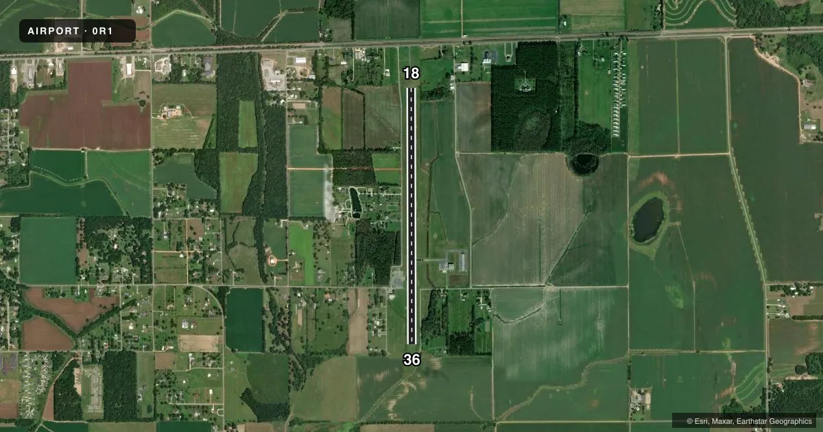
Airport sketch
Runways drawn to scale from FAA survey coordinates, rendered over satellite imagery. Not for navigation.
Approaches & charts
Services on the field
Fuel grades, oxygen, maintenance, ramp storage and lighting — as declared to the FAA by the airport operator.
Fuel & services
- Fuel
- 100LL
- Oxygen (bottled)
- Not available
- Oxygen (bulk)
- Not available
- Airframe repair
- Major
- Power plant repair
- Major
- Other services
- AGRI
Ramp & ground
- Transient storage
- Tie-down
- Landing fee
- No fee published
- Customs
- Not available
- Lighting schedule
- SEE RMK
- Beacon schedule
- SS-SR
- Beacon
- White / Green (civil land)(WG)
- Wind indicator
- Lighted
- Segmented circle
- Yes
Fuel & FBOs
Cheapest 100LL and Jet A on the field and nearby. Always confirm with the FBO before taxi.
Airport notes
Surface conditions, obstructions, local procedures, lighting outages and other notes published with each FAA cycle.
General notes
- FOR CD CTC PENSACOLA APCH AT 850-266-6884 OR 850-266-6885.
Lighting notes
- ACTVT PAPI RWYS 18 & 36; MIRL RWY 18/36 - CTAF.
Other notes
- PRIOR TO FAA ACT
- 1WKENDS ON CALL.
VFR map & nearby airports
VFR sectional. Tap any ICAO chip to open that airport.
Key facts · 0R1
Answer card- ICAO
- 0R1
- Name
- ATMORE MUNI
- Location
- ATMORE, ALABAMA
- Elevation
- 286 ft MSL
- Traffic pattern altitude
- 1,286 ft MSL (1,000 AGL)
- Control tower
- Non-towered (use CTAF)
- Total runways
- 1
- Longest runway
- 18/36 · 5,001 ft
- Published ILS approaches
- 0
- Published frequencies
- 4
- Magnetic variation
- 3°
- Current flight rules
- VFR
- Current wind
- 000° at 0 kt
- Favored runway now
- –
Atmore Muni sits in Atmore, Alabama. Field elevation is 286 ft MSL. The airport has one runway. Runway 18/36 is 5,001 ft of asphalt. There is no control tower. CTAF and UNICOM are both 122.8. The published approach support is through Pensacola. No ILS approaches are published at the field.
Pattern altitude is not published. Use the standard 1,000 ft AGL for light piston traffic unless the current Chart Supplement says otherwise. The runway lights on 18 and 36 are medium intensity and are controlled on the CTAF. The precision approach path indicators are active on both runway ends. That helps on night work and on short final.
Skywarrior Flight Support is on the field. It carries 100LL. Weekend airport services are on call. For clearance delivery, Pensacola Approach is the published contact. First-time visitors should plan for an uncontrolled field with published lighting and no ILS. Check the current Chart Supplement before departure for any updates to remarks or procedures.