METAR & TAF KPQL
Current METAR
Observed 12:53Z
KPQL 271253Z 29005KT 10SM CLR 28/24 A2998 RMK AO2 SLP154 T02780244
- Wind
- 290° @ 5 kt
- Visibility
- 10 SM
- Temp / Dew
- 28°C / 24°C
- Altimeter
- 29.98 inHg
- Clouds
- CLR
- Density alt
- 1,506 ft
- Ceiling
- Unlimited
- Rules
- VFR
Airport info & contacts
Manager on record, flight service, ARTCC, attendance schedule and pattern altitude — published by the FAA and refreshed every 28 days.
Location
- From city
- 6 NM N
- VFR sectional
- NEW ORLEANS
- ARTCC
- ZHU · HOUSTON
- NOTAM facility
- PQL (NOTAM-D)
Airport manager
- Name
- CINNAMON SNYDER
- Phone
- 228-475-1371
- Address
- 8301 SARACENNIA RD, STE 11, MOSS POINT MS 39563-9478
Flight service · Hours
- FSS GWO
- GREENWOOD1-800-WX-BRIEF
- Attendance
- ALL
Frequencies
Tap any row to copy the frequency to your clipboard.
Runways & pattern
Full pagePattern entry · RWY 35
LEFT TRAFFICRunway end performance
| End | TORA | TODA | ASDA | LDA | VGSI | Approach lights | Obstruction |
|---|---|---|---|---|---|---|---|
| 17 | — | — | — | — | PAPI 4-box left(3°) | MALSR | — |
| 35 | — | — | — | — | PAPI 4-box left(3°) | — | — |
Declared distances in feet. TORA = takeoff run available, TODA = takeoff distance, ASDA = accelerate-stop, LDA = landing distance.
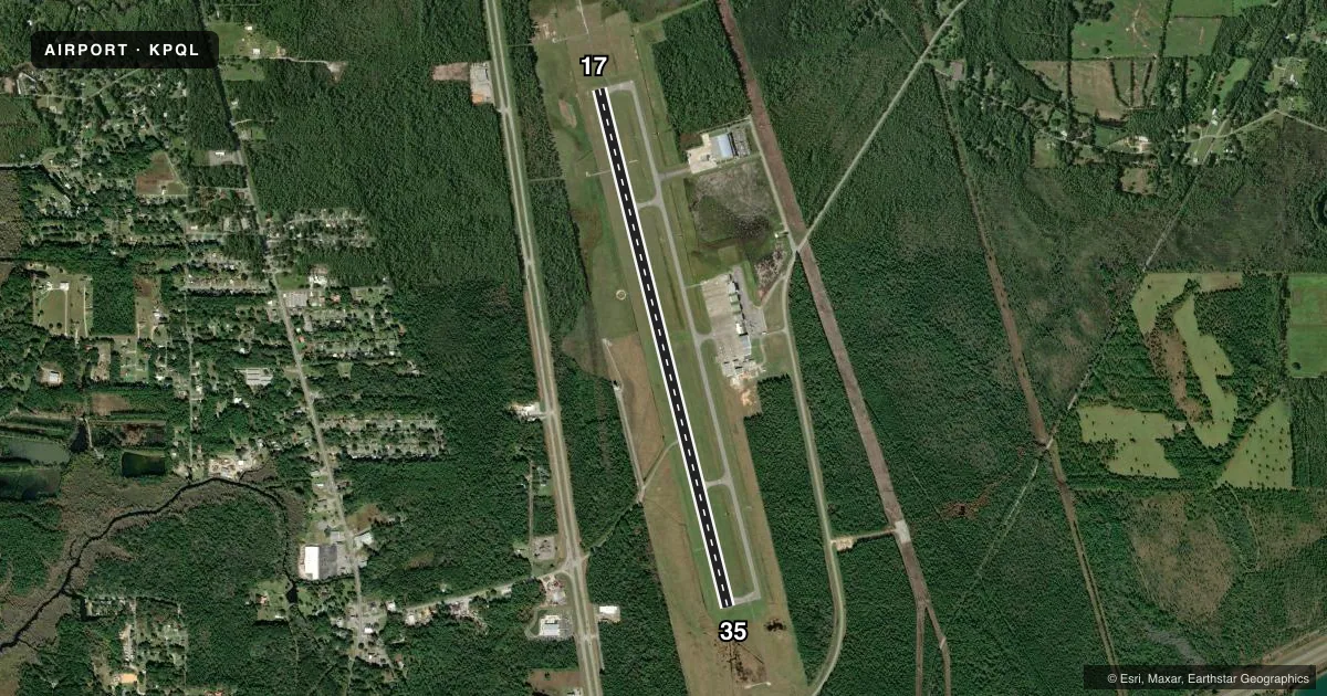
Airport sketch
Runways drawn to scale from FAA survey coordinates, rendered over satellite imagery. Not for navigation.
Approaches & charts
ILS · 1
Services on the field
Fuel grades, oxygen, maintenance, ramp storage and lighting — as declared to the FAA by the airport operator.
Fuel & services
- Fuel
- 100LLA
- Airframe repair
- Major
- Power plant repair
- Major
Ramp & ground
- Transient storage
- Tie-down
- Lighting schedule
- SEE RMK
- Beacon schedule
- SS-SR
- Beacon
- White / Green (civil land)(WG)
- Wind indicator
- Lighted
- Segmented circle
- Yes
Fuel & FBOs
Cheapest 100LL and Jet A on the field and nearby. Always confirm with the FBO before taxi.
Airport notes
Surface conditions, obstructions, local procedures, lighting outages and other notes published with each FAA cycle.
General notes
- NMRS LOW FLYING FISH SPOTTER ACFT OPRG NEAR SHORELINE BTN BAY ST LOUIS & PASCAGOULA SR-SS.
- ARFF 24 HRS.
- FOR CD WHEN ATCT CLSD CTC MOBILE APCH AT 251-662-6236, WHEN APCH CLSD CTC HOUSTON ARTCC AT 281-230-5622.
Lighting notes
- ACTVT MALSR RWY 17; PAPI RWY 35; MIRL RWY 17/35 - CTAF.
Fuel notes
- 100LLMIL CONTR FUEL AVBL.
Runway surface & condition
- 17/35UNL.
Other notes
- PRVDD ALL OPS IN VFR CONDS.
- OWNERREX FOSTER, JCAA CHAIRMAN.
- MANAGERIFUN TO CTC AMGR CALL FBO: 228-474-1000.
VFR map & nearby airports
VFR sectional. Tap any ICAO chip to open that airport.
Key facts · KPQL
Answer card- ICAO
- KPQL
- Name
- TRENT LOTT INTL
- Location
- PASCAGOULA, MISSISSIPPI
- Elevation
- 16.8 ft MSL
- Traffic pattern altitude
- 1,016.8 ft MSL (1,000 AGL)
- Control tower
- Towered · MON-FRI 0600-2000; SAT-SUN 0800-1800.
- Total runways
- 1
- Longest runway
- 17/35 · 6,501 ft
- Published ILS approaches
- 1
- Published frequencies
- 8
- Magnetic variation
- 2°
- Current flight rules
- VFR
- Current wind
- 290° at 5 kt
- Favored runway now
- RWY 35
KPQL is Trent Lott Intl in Pascagoula, Mississippi. The field elevation is 16.8 ft MSL. It has one runway, 17/35 and the longest runway is 6,501 ft of asphalt. The airport is towered. Tower hours are Monday through Friday 0600-2000. Weekend hours are Saturday and Sunday 0800-1800. One ILS approach is published for runway 17. The pattern altitude is not published, so use the standard 1,000 ft AGL for light piston traffic unless the current Chart Supplement says otherwise.
Southern Sky Aviation is on the field. It carries 100LL, Jet A and Jet A Prist. Call 228-474-1000 for current service details. The published remarks also note MALSR on runway 17. PAPI is on runway 35. Medium intensity runway lights are on both ends. They are controlled by CTAF when the tower is closed. ARFF is available 24 hours. One operational item to keep in mind is the shoreline traffic. Numerous low-flying fish spotter aircraft work the coast between Bay St Louis and Pascagoula from sunrise to sunset. That makes a good lookout scan important on arrival and departure. The airport is in the Gulf Coast area. Expect a low-elevation coastal environment rather than terrain issues. Check the current FAA Chart Supplement for any updated procedures before you go.