METAR & TAF KTUP
Current METAR
Observed 06:53Z
KTUP 270653Z AUTO 5SM BR SCT045 27/27 A2992 RMK AO2 SLP124 T02720267 $
- Wind
- Calm
- Visibility
- 5 SM
- Temp / Dew
- 27°C / 27°C
- Altimeter
- 29.92 inHg
- Clouds
- SCT
- Density alt
- 1,870 ft
- Ceiling
- Unlimited
- Rules
- MVFR
Airport info & contacts
Manager on record, flight service, ARTCC, attendance schedule and pattern altitude — published by the FAA and refreshed every 28 days.
Location
- From city
- 3 NM W
- VFR sectional
- MEMPHIS
- ARTCC
- ZME · MEMPHIS
- NOTAM facility
- TUP (NOTAM-D)
Airport manager
- Name
- BRANDON PANNELL
- Phone
- 662-841-6570
- Address
- 2704 W JACKSON ST, TUPELO MS 38801
Flight service · Hours
- FSS GWO
- GREENWOOD1-800-WX-BRIEF
- Attendance
- 0600-2200
Frequencies
Tap any row to copy the frequency to your clipboard.
Runways & pattern
Full pagePattern entry · RWY 18
LEFT TRAFFICRunway end performance
| End | TORA | TODA | ASDA | LDA | VGSI | Approach lights | Obstruction |
|---|---|---|---|---|---|---|---|
| 18 | — | — | — | — | PAPI 4-box left(3°) | — | — |
| 36 | — | — | — | — | PAPI 4-box left(3°) | MALSR | — |
Declared distances in feet. TORA = takeoff run available, TODA = takeoff distance, ASDA = accelerate-stop, LDA = landing distance.
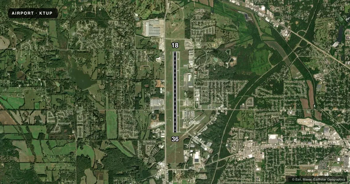
Airport sketch
Runways drawn to scale from FAA survey coordinates, rendered over satellite imagery. Not for navigation.
Approaches & charts
ILS · 1
Services on the field
Fuel grades, oxygen, maintenance, ramp storage and lighting — as declared to the FAA by the airport operator.
Fuel & services
- Fuel
- 100LLAA+A1+
- Oxygen (bottled)
- HIGH/LOW
- Oxygen (bulk)
- Not available
- Airframe repair
- Major
- Power plant repair
- Major
- Other services
- AGRI,INSTR,RNTL
Ramp & ground
- Transient storage
- Tie-down
- Hangar
- Buoy
- Landing fee
- No fee published
- Customs
- Not available
- Lighting schedule
- SEE RMK
- Beacon schedule
- SS-SR
- Beacon
- White / Green (civil land)(WG)
- Wind indicator
- Lighted
- Segmented circle
- Yes
Fuel & FBOs
Cheapest 100LL and Jet A on the field and nearby. Always confirm with the FBO before taxi.
Airport notes
Surface conditions, obstructions, local procedures, lighting outages and other notes published with each FAA cycle.
General notes
- CAUTION: HEL OPS ALL HRS 700 FT AGL E OF RWY 18/36 - CTC CTAF FOR ADZY.
- ACR RAMP RSTRD TO ACR OPS EXCP WITH PPR. CALL AMGR MON-FRI 0800-1700; 662-841-6570.
- ARNG: SUPPORT FAC OPR 1300-2200Z++ MON-FRI EXC HOL. LTD PRK AVBL. NO TSNT FUEL AVBL. DSN 293-3438, C662-891-4438.
Lighting notes
- ACTVT MALSR RWY 36; REIL RWY 18; HIRL 18/36 - CTAF. PAPI RWY 18 & 36 OPR CONSLY.
Fuel notes
- A+FUEL SVC AVBL 24 HRS WITH CREDIT CARD.
Runway surface & condition
- 18/36PCR VALUE: 72/F/C/W/T
Other notes
- EXISTED PRIOR TO 1959.
- PPR FOR UNSKED ACR OPS WITH MORE THAN 30 PAX SEATS CALL AMGR 662-841-6570. INDEX B ARFF EQPT AVBL ONLY DURING SKED ACR OPS.
- T-HNGRS.
- OWNEREXT 8.
VFR map & nearby airports
VFR sectional. Tap any ICAO chip to open that airport.
Key facts · KTUP
Answer card- ICAO
- KTUP
- Name
- TUPELO RGNL
- Location
- TUPELO, MISSISSIPPI
- Elevation
- 346.5 ft MSL
- Traffic pattern altitude
- 1,346.5 ft MSL (1,000 AGL)
- Control tower
- Towered · 0600-2200
- Total runways
- 1
- Longest runway
- 18/36 · 7,150 ft
- Published ILS approaches
- 1
- Published frequencies
- 5
- Magnetic variation
- 2°
- Current flight rules
- MVFR
- Current wind
- Calm / unavailable
- Favored runway now
- –
Tupelo Rgnl sits in Tupelo, Mississippi. Field elevation is 346.5 ft MSL. The airport has one runway, 18/36, at 7,150 ft. The tower is open 0600 to 2200 local. Runway 36 has the ILS. Pattern altitude is not published, so use 1,000 ft AGL for light piston traffic unless ATC or the current Chart Supplement says otherwise.
Tupelo Aviation is the on-field FBO. It carries 100LL and Jet A Prist. Fuel service is available 24 hours with credit card. Published remarks also say the ramp is restricted to aircraft operations unless you have prior permission. Limited parking is noted. There is also a helicopter caution east of runway 18/36 at 700 ft AGL. That matters on departure and arrival planning.
The field has runway 18 and 36 lighting, with high intensity lights controlled by CTAF. MALSR is active on runway 36. REILs are on runway 18. Precision approach path indicators operate continuously on both ends. This is a controlled airport with active traffic and support limits, so call ahead if you need ramp access or special handling. Check the current FAA Chart Supplement for any current operational notes before you go.