METAR & TAF 22M
22M does not publish a METAR.
Showing the nearest reporting station: KTUP (TUPELO RGNL) · 13.3 NM away. Conditions at 22M may differ.
METAR · KTUP
Observed 04:53Z
KTUP 270453Z AUTO 6SM BR CLR 28/27 A2996 RMK AO2 SLP138 T02780272 $
- Wind
- Calm
- Visibility
- 6 SM
- Temp / Dew
- 28°C / 27°C
- Altimeter
- 29.96 inHg
- Clouds
- CLR
- Density alt
- 2,056 ft
- Ceiling
- Unlimited
- Rules
- VFR
Airport info & contacts
Manager on record, flight service, ARTCC, attendance schedule and pattern altitude — published by the FAA and refreshed every 28 days.
Location
- From city
- 2 NM NW
- VFR sectional
- MEMPHIS
- ARTCC
- ZME · MEMPHIS
- NOTAM facility
- GWO (NOTAM-D)
Airport manager
- Name
- TED MCVAY
- Phone
- (662) 891-5593
- Address
- PO BOX 209, PONTOTOC MS 38863-0209
Flight service · Hours
- FSS GWO
- GREENWOOD1-800-WX-BRIEF
- Attendance
- Unattended
Frequencies
Tap any row to copy the frequency to your clipboard.
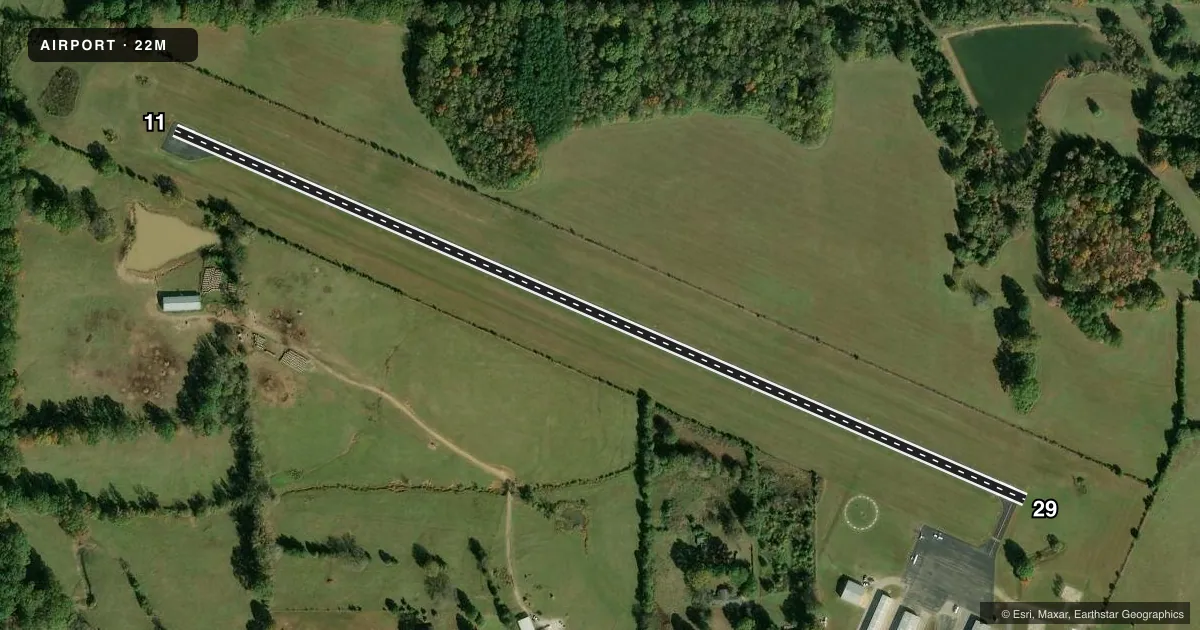
Runways & pattern
Full pagePattern entry · RWY 11
LEFT TRAFFICRunway end performance
| End | TORA | TODA | ASDA | LDA | VGSI | Approach lights | Obstruction |
|---|---|---|---|---|---|---|---|
| 11 | — | — | — | — | — | — | 20', tree, 600' from thr, slope 20 |
| 29 | — | — | — | — | — | — | 60', trees, 1400' from thr, slope 20 |
Declared distances in feet. TORA = takeoff run available, TODA = takeoff distance, ASDA = accelerate-stop, LDA = landing distance.
Airport sketch
Runways drawn to scale from FAA survey coordinates, rendered over satellite imagery. Not for navigation.
Approaches & charts
Services on the field
Fuel grades, oxygen, maintenance, ramp storage and lighting — as declared to the FAA by the airport operator.
Fuel & services
- Fuel
- 100LL
- Oxygen (bottled)
- Not available
- Oxygen (bulk)
- Not available
- Airframe repair
- Major
- Power plant repair
- Major
- Other services
- INSTR
Ramp & ground
- Transient storage
- Tie-down
- Landing fee
- No fee published
- Customs
- Not available
- Lighting schedule
- SS-SR
- Beacon schedule
- SS-SR
- Beacon
- White / Green (civil land)(WG)
- Wind indicator
- Lighted
- Segmented circle
- Yes
Fuel & FBOs
Cheapest 100LL and Jet A on the field and nearby. Always confirm with the FBO before taxi.
Airport notes
Surface conditions, obstructions, local procedures, lighting outages and other notes published with each FAA cycle.
General notes
- FOR CD CTC MEMPHIS ARTCC AT 901-368-8453/8449.
Fuel notes
- 100LLFUEL AVBL 24 HRS WITH CREDIT CARD.
Other notes
- PILOTS MUST PRVD THEIR OWN TIEDOWN ROPES.
- 2FOR ATTENDANT & EMERG SVC CALL 662-489-3111.
- MANAGERCHAIRMAN OF ARPT BOARD.
- OWNERCHANCERY CLERK'S OFC.
VFR map & nearby airports
VFR sectional. Tap any ICAO chip to open that airport.
Key facts · 22M
Answer card- ICAO
- 22M
- Name
- PONTOTOC COUNTY
- Location
- PONTOTOC, MISSISSIPPI
- Elevation
- 440 ft MSL
- Traffic pattern altitude
- 1,440 ft MSL (1,000 AGL)
- Control tower
- Non-towered (use CTAF)
- Total runways
- 1
- Longest runway
- 11/29 · 3,000 ft
- Published ILS approaches
- 0
- Published frequencies
- 2
- Magnetic variation
- 2°
- Current flight rules
- VFR
- Current wind
- Calm / unavailable
- Favored runway now
- –
Pontotoc County Airport sits in Pontotoc, Mississippi. The field elevation is 440 ft MSL. It has one runway. Runway 11/29 is 3,000 ft long and asphalt. The airport is not towered. CTAF and UNICOM are both 122.8.
No ILS approaches are published here. The pattern altitude is not published, so use the standard 1,000 ft AGL for light piston operations unless the current Chart Supplement says otherwise. Runway headings are magnetic. Runway 11 is 113°. Runway 29 is 293°.
There are no on-field FBOs listed. Fuel is available 24 hours with credit card. The published remarks also say pilots must provide their own tiedown ropes. For attendant and emergency service, call 662-489-3111. For clearance delivery, contact Memphis ARTCC at 901-368-8453 or 901-368-8449. If you are planning a first stop here, verify current field conditions and any local procedures before arrival. This is a small uncontrolled airport, so expect self-announce traffic and keep a close ear on 122.8.