METAR & TAF 8M1
8M1 does not publish a METAR.
Showing the nearest reporting station: KCRX (ROSCOE TURNER) · 19.5 NM away. Conditions at 8M1 may differ.
METAR · KCRX
Observed 09:15Z
KCRX 130915Z AUTO 00000KT 1/2SM BR VV005 18/18 A3003 RMK AO2
- Wind
- 000° @ 0 kt
- Visibility
- 0.5 SM
- Temp / Dew
- 18°C / 18°C
- Altimeter
- 30.03 inHg
- Clouds
- VV
- Density alt
- 710 ft
- Ceiling
- 500 ft AGL
- Rules
- LIFR
Airport info & contacts
Manager on record, flight service, ARTCC, attendance schedule and pattern altitude — published by the FAA and refreshed every 28 days.
Location
- From city
- 6 NM SW
- VFR sectional
- MEMPHIS
- ARTCC
- ZME · MEMPHIS
- NOTAM facility
- GWO (NOTAM-D)
Airport manager
- Name
- TERRY ROBERTS
- Phone
- 662-210-1773
- Address
- 178 CR 7450, BALDWYN MS 38824
Flight service · Hours
- FSS GWO
- GREENWOOD1-800-WX-BRIEF
- Attendance
- 0800-1400
Frequencies
Tap any row to copy the frequency to your clipboard.
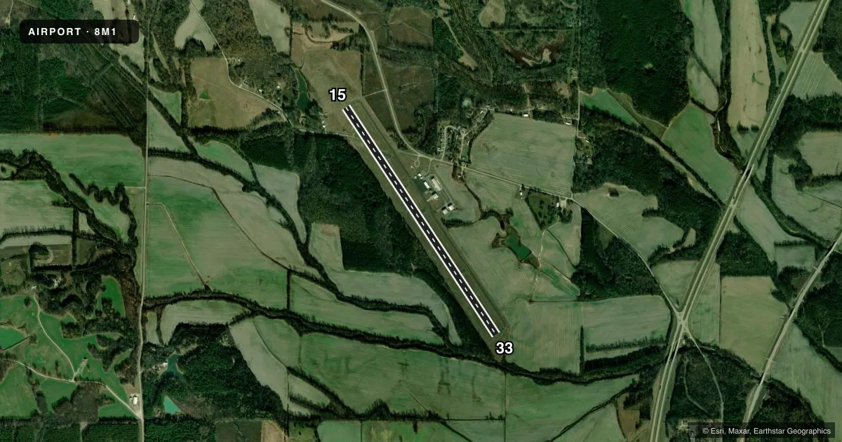
Runways & pattern
Full pagePattern entry · RWY 15
LEFT TRAFFICRunway end performance
| End | TORA | TODA | ASDA | LDA | VGSI | Approach lights | Obstruction |
|---|---|---|---|---|---|---|---|
| 15 | — | — | — | — | PAPI 2-box left(3°) | — | 58', trees, 1360' from thr, 300' R of cntrln, slope 20 |
| 33 | — | — | — | — | PAPI 2-box left(3°) | — | 105', trees, 3269' from thr, 800' R of cntrln, slope 29 |
Declared distances in feet. TORA = takeoff run available, TODA = takeoff distance, ASDA = accelerate-stop, LDA = landing distance.
Airport sketch
Runways drawn to scale from FAA survey coordinates, rendered over satellite imagery. Not for navigation.
Approaches & charts
Services on the field
Fuel grades, oxygen, maintenance, ramp storage and lighting — as declared to the FAA by the airport operator.
Fuel & services
- Fuel
- 100LLA
- Oxygen (bottled)
- Not available
- Oxygen (bulk)
- Not available
- Other services
- AGRI,CHTR
Ramp & ground
- Transient storage
- Tie-down
- Hangar
- Landing fee
- No fee published
- Customs
- Not available
- Lighting schedule
- SEE RMK
- Beacon schedule
- SS-SR
- Beacon
- White / Green (civil land)(WG)
- Wind indicator
- Lighted
- Segmented circle
- Yes
Fuel & FBOs
Cheapest 100LL and Jet A on the field and nearby. Always confirm with the FBO before taxi.
Airport notes
Surface conditions, obstructions, local procedures, lighting outages and other notes published with each FAA cycle.
General notes
- FOR CD CTC MEMPHIS ARTCC AT 901-368-8453/8449.
- COURTESY VEHICLE AVBL.
Lighting notes
- ACTVT MIRL RWY 15/33 - CTAF.
Fuel notes
- 100LLFUEL AVBL 24 HRS WITH CREDIT CARD.
Other notes
- VFR OPS ONLY.
- HNGR AVBL. RES ONE WEEK IN ADVN.
- OWNERBALDWYN & COUNTY OF PRENTISS. TOMMY BARAGONA, CHAIRMAN ARPT BOARD.
- CHTR731-434-7307.
VFR map & nearby airports
VFR sectional. Tap any ICAO chip to open that airport.
Key facts · 8M1
Answer card- ICAO
- 8M1
- Name
- BOONEVILLE/BALDWYN
- Location
- BOONEVILLE/BALDWYN, MISSISSIPPI
- Elevation
- 392.2 ft MSL
- Traffic pattern altitude
- 1,392.2 ft MSL (1,000 AGL)
- Control tower
- Non-towered (use CTAF)
- Total runways
- 1
- Longest runway
- 15/33 · 5,003 ft
- Published ILS approaches
- 0
- Published frequencies
- 2
- Magnetic variation
- 1°
- Current flight rules
- LIFR
- Current wind
- 000° at 0 kt
- Favored runway now
- –
BOONEVILLE/BALDWYN Airport sits in Booneville/Baldwyn, Mississippi. Field elevation is 392.2 ft MSL. The airport has one runway. Runway 15/33 is 5,003 ft long with asphalt pavement. It is a non-towered field. CTAF and UNICOM are both 122.8. No ILS approaches are published here.
Pattern altitude is not published. Use 1,000 ft AGL for light piston operations unless the current Chart Supplement says otherwise. The field is VFR operations only. Medium intensity runway lights on 15/33 are activated by CTAF. That helps for night arrivals. You still need to verify current procedures before you go.
Booneville-Baldwyn Airport has one on-field FBO. Booneville-Baldwyn Airport carries 100LL, Jet A and Jet A Prist. 100LL is available 24 hours with credit card. If you need fuel or local help, call the FBO at (662) 365-8811. A courtesy vehicle is available. Hangar space is available too, but it needs a one-week reservation.
For clearance delivery, contact Memphis ARTCC at 901-368-8453 or 901-368-8449. The airport is owned by Baldwyn and County of Prentiss. First-time pilots should plan for an uncontrolled VFR environment. Confirm current runway lighting and local procedures before arrival.