METAR & TAF KUOX
Current METAR
Observed 12:55Z
KUOX 271255Z AUTO VRB03KT 10SM CLR 27/24 A3001 RMK AO2
- Wind
- VAR @ 3 kt
- Visibility
- 10 SM
- Temp / Dew
- 27°C / 24°C
- Altimeter
- 30.01 inHg
- Clouds
- CLR
- Density alt
- 1,889 ft
- Ceiling
- Unlimited
- Rules
- VFR
Airport info & contacts
Manager on record, flight service, ARTCC, attendance schedule and pattern altitude — published by the FAA and refreshed every 28 days.
Location
- From city
- 2 NM NW
- VFR sectional
- MEMPHIS
- Pattern altitude
- 800 ft AGL · 1,252 ft MSL
- ARTCC
- ZME · MEMPHIS
- NOTAM facility
- GWO (NOTAM-D)
Airport manager
- Name
- JACOB PIND
- Phone
- 662-234-2036
- Address
- UNIVERSITY-OXFORD AIRPORT, OXFORD MS 38655
Flight service · Hours
- FSS GWO
- GREENWOOD1-800-WX-BRIEF
- Attendance
- 0700-1900
Frequencies
Tap any row to copy the frequency to your clipboard.
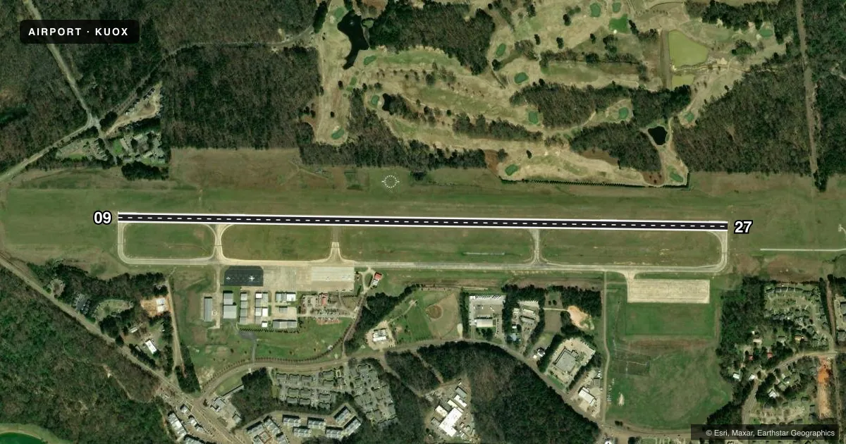
Runways & pattern
Full pagePattern entry · RWY 27
LEFT TRAFFICRunway end performance
| End | TORA | TODA | ASDA | LDA | VGSI | Approach lights | Obstruction |
|---|---|---|---|---|---|---|---|
| 09 | — | — | — | — | PAPI 4-box left(3°) | — | — |
| 27 | — | — | — | — | PAPI 4-box left(3.6°) | — | 40', tree, 800' from thr, 75' R of cntrln, slope 15 |
Declared distances in feet. TORA = takeoff run available, TODA = takeoff distance, ASDA = accelerate-stop, LDA = landing distance.
Airport sketch
Runways drawn to scale from FAA survey coordinates, rendered over satellite imagery. Not for navigation.
Approaches & charts
ILS · 1
Services on the field
Fuel grades, oxygen, maintenance, ramp storage and lighting — as declared to the FAA by the airport operator.
Fuel & services
- Fuel
- 100LLAA+
- Oxygen (bottled)
- Not available
- Oxygen (bulk)
- Not available
- Airframe repair
- Not available
- Power plant repair
- Not available
Ramp & ground
- Transient storage
- Tie-down
- Landing fee
- No fee published
- Customs
- Not available
- Lighting schedule
- SEE RMK
- Beacon schedule
- SS-SR
- Beacon
- White / Green (civil land)(WG)
- Wind indicator
- Lighted
- Segmented circle
- Yes
Fuel & FBOs
Cheapest 100LL and Jet A on the field and nearby. Always confirm with the FBO before taxi.
Airport notes
Surface conditions, obstructions, local procedures, lighting outages and other notes published with each FAA cycle.
General notes
- GCO AVBL ON FREQ 135.075 FOR MEMPHIS ARTCC (ZME).
- FOR CD IF UNA VIA GCO CTC MEMPHIS ARTCC AT 901-368-8453/8449.
- ARPT SFC CONDS NOT MNTD.
Lighting notes
- MIRL RWY 09/27 OPRS DUSK-2200. AFT 2200, ACTVT REIL 09 & 27; PAPI RWY 09; MIRL RWY 09/27 - CTAF. PAPI RWY 27 OPR CONSLY.
Runway surface & condition
- 09/27PCR VALUE: 390/F/C/X/T
Approach & departure obstructions
- 27PAPI UNUSBL BYD 6 DEG L OF CNTRLN.
Other notes
- PRIOR TO FAA ACT.
- CLSD TO ACR OPS WITH MORE THAN 30 PAX SEATS EXCP PPR CALL AMGR 662-234-2036.
- TPA: 800 FT AGL LGT ACFT, 1200 FT AGL HI SPD ACFT.
- 1FOR ARPT ATTENDANT NIGHTS CALL 662-832-5689 OR 662-202-4905.
VFR map & nearby airports
VFR sectional. Tap any ICAO chip to open that airport.
Key facts · KUOX
Answer card- ICAO
- KUOX
- Name
- UNIVERSITY-OXFORD
- Location
- OXFORD, MISSISSIPPI
- Elevation
- 452 ft MSL
- Traffic pattern altitude
- 1,252 ft MSL (800 AGL)
- Control tower
- Non-towered (use CTAF)
- Total runways
- 1
- Longest runway
- 09/27 · 5,600 ft
- Published ILS approaches
- 1
- Published frequencies
- 2
- Magnetic variation
- 1°
- Current flight rules
- VFR
- Current wind
- 000° at 3 kt
- Favored runway now
- RWY 27
University-Oxford Airport (KUOX) sits in Oxford, Mississippi. Field elevation is 452 ft MSL. The airport has one runway. Runway 09/27 is 5,600 ft long with an asphalt surface. There is no control tower. CTAF and UNICOM are both 123.0.
The field has one ILS approach to runway 09. Pattern altitude is 800 ft AGL, which is 1,252 ft MSL for light aircraft. High speed aircraft use 1,200 ft AGL. The on-field FBO is University-Oxford Airport. It carries AVGAS 100LL and Jet A. Call the FBO at (662) 234-2036 for current service details.
A few operational notes matter here. Runway lights on 09/27 are medium intensity and are controlled by CTAF. They operate from dusk to 2200. After 2200, runway end identifier lights are active on runways 09 and 27. The PAPI is available on runway 09. The PAPI on runway 27 runs continuously. The runway 27 PAPI is unusable beyond 6 degrees left of centerline. Airport surface conditions are not maintained, so plan for that if weather has been active. The airport also notes prior permission for aircraft rescue and fire fighting operations with more than 30 passenger seats. Check the current Chart Supplement and call the airport operator if you need anything operational before arrival.