METAR & TAF M53
M53 does not publish a METAR.
Showing the nearest reporting station: KMKL (JACKSON RGNL) · 12.3 NM away. Conditions at M53 may differ.
METAR · KMKL
Observed 11:19Z
KMKL 271119Z AUTO 10004KT 10SM VCTS -RA SCT045 BKN050 OVC080 23/22 A3003 RMK AO1 LTG DSNT E AND SE RAB09 T02330217 PNO $
- Wind
- 100° @ 4 kt
- Visibility
- 10 SM
- Temp / Dew
- 23°C / 22°C
- Altimeter
- 30.03 inHg
- Clouds
- OVC
- Density alt
- 1,346 ft
- Ceiling
- 5,000 ft AGL
- Rules
- VFR
Airport info & contacts
Manager on record, flight service, ARTCC, attendance schedule and pattern altitude — published by the FAA and refreshed every 28 days.
Location
- From city
- 3 NM SE
- VFR sectional
- MEMPHIS
- ARTCC
- ZME · MEMPHIS
- NOTAM facility
- MKL (NOTAM-D)
Airport manager
- Name
- DAVID P. POPE
- Phone
- 731-618-9089
- Address
- 4655 EAST MAIN ST, HUMBOLDT TN 38343
Flight service · Hours
- FSS MKL
- JACKSON1-800-WX-BRIEF
- Attendance
- MON-FRI · 0730-1630
Frequencies
Tap any row to copy the frequency to your clipboard.
Runways & pattern
Full pagePattern entry · RWY 04
LEFT TRAFFICRunway end performance
| End | TORA | TODA | ASDA | LDA | VGSI | Approach lights | Obstruction |
|---|---|---|---|---|---|---|---|
| 04 | — | — | — | — | PAPI 2-box left(3°) | — | 72', trees, 1405' from thr, 90' R of cntrln, slope 16 |
| 22 | — | — | — | — | PAPI 2-box left(3°) | — | 29', trees, 742' from thr, 132' R of cntrln, slope 18 |
Declared distances in feet. TORA = takeoff run available, TODA = takeoff distance, ASDA = accelerate-stop, LDA = landing distance.
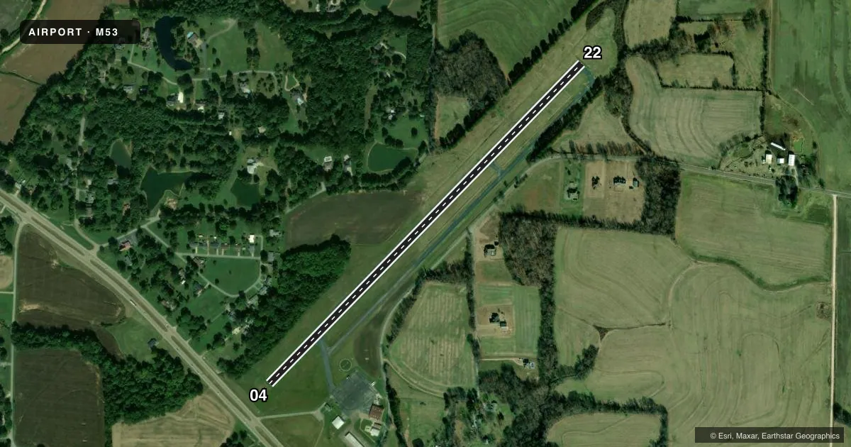
Airport sketch
Runways drawn to scale from FAA survey coordinates, rendered over satellite imagery. Not for navigation.
Approaches & charts
Services on the field
Fuel grades, oxygen, maintenance, ramp storage and lighting — as declared to the FAA by the airport operator.
Fuel & services
- Fuel
- 100LLA
- Oxygen (bottled)
- Not available
- Oxygen (bulk)
- Not available
- Airframe repair
- Not available
- Power plant repair
- Not available
- Other services
- AMB
Ramp & ground
- Transient storage
- Tie-down
- Hangar
- Landing fee
- No fee published
- Customs
- Not available
- Lighting schedule
- SS-SR
- Beacon schedule
- SS-SR
- Beacon
- White / Green (civil land)(WG)
- Wind indicator
- Lighted
- Segmented circle
- Yes
Fuel & FBOs
Cheapest 100LL and Jet A on the field and nearby. Always confirm with the FBO before taxi.
Airport notes
Surface conditions, obstructions, local procedures, lighting outages and other notes published with each FAA cycle.
General notes
- AGRICULTURAL ACFT OPS ON & INVOF ARPT.
- FOR CD CTC MEMPHIS ARTCC AT 901-368-8453/8449.
- PILOT ENTRANCE CODE 1228.
- 24/7 CREDIT CARD FUEL AVBL.
Runway surface & condition
- 04/2215-30 FT TREES W OF RWY VIOLATE TRANSITION SLOPE.
VFR map & nearby airports
VFR sectional. Tap any ICAO chip to open that airport.
Key facts · M53
Answer card- ICAO
- M53
- Name
- HUMBOLDT MUNI
- Location
- HUMBOLDT, TENNESSEE
- Elevation
- 421.2 ft MSL
- Traffic pattern altitude
- 1,421.2 ft MSL (1,000 AGL)
- Control tower
- Non-towered (use CTAF)
- Total runways
- 1
- Longest runway
- 04/22 · 4,003 ft
- Published ILS approaches
- 0
- Published frequencies
- 2
- Magnetic variation
- 2°
- Current flight rules
- VFR
- Current wind
- 100° at 4 kt
- Favored runway now
- RWY 04
Humboldt Muni is in Humboldt, Tennessee. The field elevation is 421.2 ft MSL. It has one runway, 04/22, which is 4,003 ft long and asphalt. There is no control tower. CTAF and UNICOM are both 122.8.
No ILS approaches are published here. The pattern altitude is not published, so use the standard 1,000 ft AGL for light piston traffic unless the current Chart Supplement says otherwise. The on-field FBO is Humboldt Municipal Airport. It carries 100LL and Jet A. Credit card fuel is available 24 hours a day, 7 days a week. The pilot entrance code is 1228.
A first-time pilot should pay attention to the published remarks. Agricultural aircraft operations occur on and near the airport. Trees west of runway 04/22 rise into the transition slope, so watch your departure and arrival path on that side. For clearance delivery, Memphis ARTCC handles it by phone. This is an uncontrolled field, so keep your eyes outside and make your calls early. If you need current noise, curfew, or other local operating limits, check the current FAA Chart Supplement or call the airport operator before departure.