METAR & TAF KDYR
Current METAR
Observed 13:56Z
KDYR 261356Z AUTO 24005KT 10SM SCT045 29/ A3000 RMK AO2 SLP161 T0289 $
- Wind
- 240° @ 5 kt
- Visibility
- 10 SM
- Temp / Dew
- —
- Altimeter
- 30.00 inHg
- Clouds
- SCT
- Density alt
- —
- Ceiling
- Unlimited
- Rules
- VFR
Airport info & contacts
Manager on record, flight service, ARTCC, attendance schedule and pattern altitude — published by the FAA and refreshed every 28 days.
Location
- From city
- 2 NM S
- VFR sectional
- ST LOUIS
- ARTCC
- ZME · MEMPHIS
- NOTAM facility
- DYR (NOTAM-D)
Airport manager
- Name
- DIAN DAWSON
- Phone
- 731-445-3979
- Address
- 315 AIRPORT ROAD, DYERSBURG TN 38024
Flight service · Hours
- FSS MKL
- JACKSON1-800-WX-BRIEF
- Attendance
- MON-FRI · 0700-1700
- SAT-SUN · 0800-1700
Frequencies
Tap any row to copy the frequency to your clipboard.
Runways & pattern
Full pagePattern entry · RWY 22
LEFT TRAFFIC| Runway | Heading (°M) | Length | Surface | Traffic |
|---|---|---|---|---|
| 04/22Favored | 39° / 220° | 5,698 ft | ASPH | Standard L |
| 16/34 | 161° / 341° | 4,001 ft | ASPH | Standard L |
Runway end performance
| End | TORA | TODA | ASDA | LDA | VGSI | Approach lights | Obstruction |
|---|---|---|---|---|---|---|---|
| 04 | — | — | — | — | PAPI 4-box left(3°) | — | 69', tree, 1471' from thr, 370' R of cntrln, slope 18 |
| 22 | — | — | — | — | PAPI 4-box left(3°) | — | — |
| 16 | — | — | — | — | — | — | 27', tree, 947' from thr, 292' R of cntrln, slope 27 |
| 34 | — | — | — | — | — | — | 78', tree, 816' from thr, 355' R of cntrln, slope 7 |
Declared distances in feet. TORA = takeoff run available, TODA = takeoff distance, ASDA = accelerate-stop, LDA = landing distance.
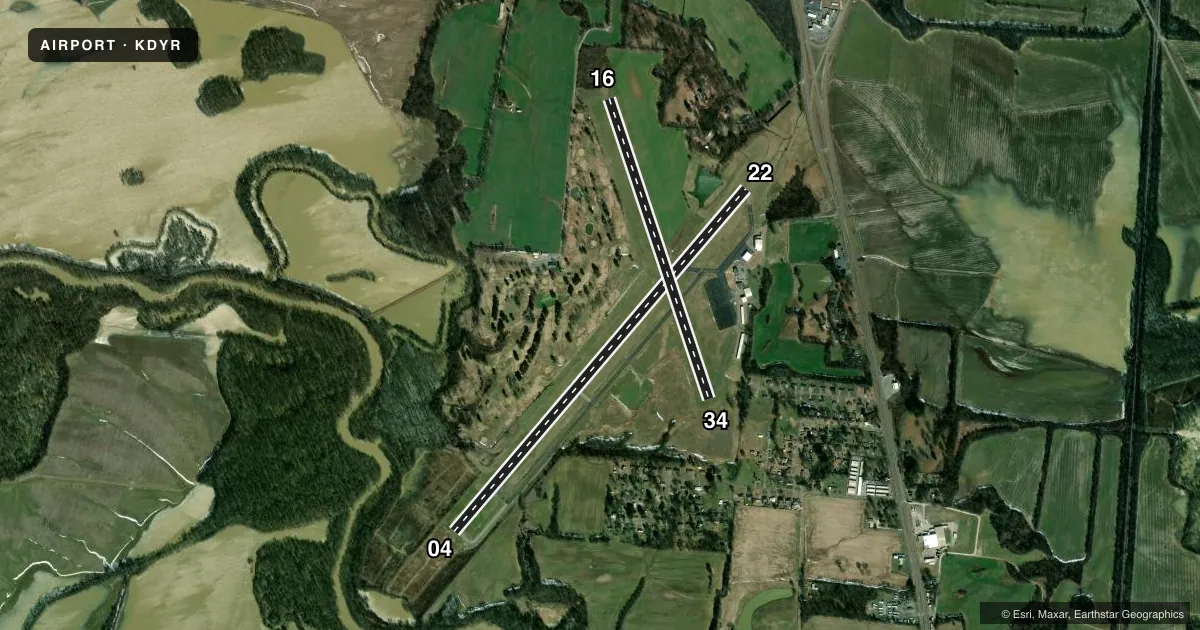
Airport sketch
Runways drawn to scale from FAA survey coordinates, rendered over satellite imagery. Not for navigation.
Approaches & charts
Services on the field
Fuel grades, oxygen, maintenance, ramp storage and lighting — as declared to the FAA by the airport operator.
Fuel & services
- Fuel
- 100LLA+
- Oxygen (bottled)
- Not available
- Oxygen (bulk)
- Not available
- Airframe repair
- Not available
- Power plant repair
- Not available
Ramp & ground
- Transient storage
- Tie-down
- Hangar
- Landing fee
- No fee published
- Customs
- Not available
- Lighting schedule
- SEE RMK
- Beacon schedule
- SS-SR
- Beacon
- White / Green (civil land)(WG)
- Wind indicator
- Lighted
- Segmented circle
- Yes
Fuel & FBOs
Cheapest 100LL and Jet A on the field and nearby. Always confirm with the FBO before taxi.
Airport notes
Surface conditions, obstructions, local procedures, lighting outages and other notes published with each FAA cycle.
General notes
- FOR CD CTC MEMPHIS ARTCC AT 901-368-8453/8449.
Lighting notes
- ACTVT REIL RWY 04 & 22; MIRL RWY 04/22 - CTAF. PAPI RWY 04 & 22 ON CONSLY.
Runway surface & condition
- 16/34CLSD INDEFLY.
VFR map & nearby airports
VFR sectional. Tap any ICAO chip to open that airport.
Key facts · KDYR
Answer card- ICAO
- KDYR
- Name
- DYERSBURG RGNL
- Location
- DYERSBURG, TENNESSEE
- Elevation
- 337.7 ft MSL
- Traffic pattern altitude
- 1,337.7 ft MSL (1,000 AGL)
- Control tower
- Non-towered (use CTAF)
- Total runways
- 2
- Longest runway
- 04/22 · 5,698 ft
- Published ILS approaches
- 0
- Published frequencies
- 2
- Magnetic variation
- 1°
- Current flight rules
- VFR
- Current wind
- 240° at 5 kt
- Favored runway now
- RWY 22
Dyersburg Regional Airport sits in Dyersburg, Tennessee. Field elevation is 337.7 ft MSL. The airport has two asphalt runways. The longest is runway 04/22 at 5,698 ft. Runway 16/34 is 4,001 ft, but it is closed indefinitely, so plan around 04/22 for current operations.
This is an untowered field. CTAF and UNICOM are both 123.05. No ILS approaches are published here, so check the current chart and plan for nonprecision work if you need an instrument arrival. Pattern altitude is not published. Use the standard 1,000 ft AGL pattern unless current local guidance says otherwise. That puts the light piston pattern near 1,338 ft MSL.
Dyersburg Regional Airport has one on-field FBO. Dyersburg Regional Airport carries AVGAS 100LL and Jet A Prist. Call the FBO directly at (731) 287-8181 for current service details before you go. Published remarks also note that runway 04 and runway 22 have active runway end identifier lights. Medium intensity runway lights are controlled by CTAF. PAPI is on both ends and stays on continuously. For clearance delivery, contact Memphis ARTCC at 901-368-8453 or 901-368-8449. First-time arrivals should pay attention to the closed 16/34 runway and verify current runway lighting and airport status before departure.