METAR & TAF M05
M05 does not publish a METAR.
Showing the nearest reporting station: KHKA (BLYTHEVILLE MUNI) · 15.6 NM away. Conditions at M05 may differ.
METAR · KHKA
Observed 12:53Z
KHKA 271253Z AUTO 15007KT 10SM CLR 26/22 A2997 RMK AO2 SLP145 T02610217 PWINO $
- Wind
- 150° @ 7 kt
- Visibility
- 10 SM
- Temp / Dew
- 26°C / 22°C
- Altimeter
- 29.97 inHg
- Clouds
- CLR
- Density alt
- 1,590 ft
- Ceiling
- Unlimited
- Rules
- VFR
Airport info & contacts
Manager on record, flight service, ARTCC, attendance schedule and pattern altitude — published by the FAA and refreshed every 28 days.
Location
- From city
- 1 NM SW
- VFR sectional
- ST LOUIS
- ARTCC
- ZME · MEMPHIS
- NOTAM facility
- STL (NOTAM-D)
Airport manager
- Name
- JERRIE DAVIS
- Phone
- 573-333-4296
- Address
- 200 W 3RD ST., CARUTHERSVILLE MO 63830
Flight service · Hours
- FSS STL
- SAINT LOUIS1-800-WX-BRIEF
- Attendance
- MON-FRI · 0800-1630
Frequencies
Tap any row to copy the frequency to your clipboard.
Runways & pattern
Full pagePattern entry · RWY 18
RIGHT TRAFFICRunway end performance
| End | TORA | TODA | ASDA | LDA | VGSI | Approach lights | Obstruction |
|---|---|---|---|---|---|---|---|
| 18 | — | — | — | — | PAPI 4-box left(3°) | — | 83', trees, 680' from thr, 248' R of cntrln, slope 5 |
| 36 | — | — | — | — | PAPI 4-box left(3°) | — | 87', trees, 1120' from thr, 285' R of cntrln, slope 10 |
Declared distances in feet. TORA = takeoff run available, TODA = takeoff distance, ASDA = accelerate-stop, LDA = landing distance.
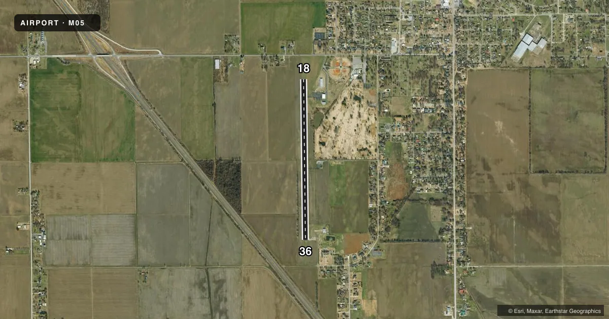
Airport sketch
Runways drawn to scale from FAA survey coordinates, rendered over satellite imagery. Not for navigation.
Approaches & charts
Services on the field
Fuel grades, oxygen, maintenance, ramp storage and lighting — as declared to the FAA by the airport operator.
Fuel & services
- Fuel
- Not available
- Airframe repair
- Not available
- Power plant repair
- Not available
- Other services
- AGRI,AVNCS
Ramp & ground
- Transient storage
- Tie-down
- Landing fee
- No fee published
- Customs
- Not available
- Lighting schedule
- SEE RMK
- Beacon schedule
- SS-SR
- Beacon
- White / Green (civil land)(WG)
- Wind indicator
- Lighted
- Segmented circle
- Yes
Fuel & FBOs
Cheapest 100LL and Jet A on the field and nearby. Always confirm with the FBO before taxi.
Airport notes
Surface conditions, obstructions, local procedures, lighting outages and other notes published with each FAA cycle.
General notes
- CROP DUSTING ACFT ON & INVOF ARPT.
- FOR CD CTC MEMPHIS ARTCC AT 901-368-8453/8449.
Lighting notes
- ACTVT MIRL RWY 18/36 - CTAF.
Approach & departure obstructions
- 18CROPS 1-3 FT TALL 0-200 FT FM THR, 50 FT- 250 FT RIGHT.
- 36CROPS 1- 3 FT TALL, 0-200 FT FM THR, 50 FT- 250 FT RIGHT, 55 FT- 250 FT LEFT.
- 18UNUSBL BYD 3 DEG L OF CNTRLN. UNUSBL BYD 5 DEG R OF CNTRLN.
- 36UNUSBL BYD 5 DEG R OF CNTRLN.
Other notes
- MANAGERARPT ADDRESS 2204 AIRPORT ROAD.
- MANAGERALTERNATE PHONE NBR 573-333-4296.
VFR map & nearby airports
VFR sectional. Tap any ICAO chip to open that airport.
Key facts · M05
Answer card- ICAO
- M05
- Name
- CARUTHERSVILLE MEML
- Location
- CARUTHERSVILLE, MISSOURI
- Elevation
- 268.1 ft MSL
- Traffic pattern altitude
- 1,268.1 ft MSL (1,000 AGL)
- Control tower
- Non-towered (use CTAF)
- Total runways
- 1
- Longest runway
- 18/36 · 4,003 ft
- Published ILS approaches
- 0
- Published frequencies
- 1
- Magnetic variation
- 0°
- Current flight rules
- VFR
- Current wind
- 150° at 7 kt
- Favored runway now
- RWY 18
Caruthersville Memorial Airport (M05) sits in Caruthersville, Missouri. Field elevation is 268.1 ft MSL. The airport has one runway. Runway 18/36 is 4,003 ft of asphalt, which is the longest runway on the field. There is no control tower. CTAF is 122.9. No ILS approaches are published here.
Pattern altitude is not published. Use 1,000 ft AGL as the standard light piston pattern unless the current Chart Supplement or local procedures say otherwise. Dyersburg Avionics is on field and carries 100LL. Their phone number is (573) 333-4296. The published remarks also note that medium intensity runway lights on 18/36 are activated by CTAF.
This is a field where the runway environment matters. Crops are reported near both thresholds. Runway 18 has unusable areas beyond 3 degrees left of centerline and beyond 5 degrees right of centerline. Runway 36 is unusable beyond 5 degrees right of centerline. Crop dusting aircraft also operate on and near the airport. Check the current Chart Supplement before you go. That is the best place to confirm any current operational notes, especially if you are planning a first arrival.