METAR & TAF KBYH
KBYH does not publish a METAR.
Showing the nearest reporting station: KHKA (BLYTHEVILLE MUNI) · 5.7 NM away. Conditions at KBYH may differ.
METAR · KHKA
Observed 03:53Z
KHKA 270353Z AUTO 19004KT 10SM CLR 29/27 A2991 RMK AO2 SLP124 T02890272 PWINO $
- Wind
- 190° @ 4 kt
- Visibility
- 10 SM
- Temp / Dew
- 29°C / 27°C
- Altimeter
- 29.91 inHg
- Clouds
- CLR
- Density alt
- 2,007 ft
- Ceiling
- Unlimited
- Rules
- VFR
Airport info & contacts
Manager on record, flight service, ARTCC, attendance schedule and pattern altitude — published by the FAA and refreshed every 28 days.
Location
- From city
- 3 NM NW
- VFR sectional
- MEMPHIS
- ARTCC
- ZME · MEMPHIS
- NOTAM facility
- BYH (NOTAM-D)
Airport manager
- Name
- TODD RILEY
- Phone
- 870-532-5628
- Address
- 4701 MEMORIAL DRIVE, BLYTHEVILLE AR 72315
Flight service · Hours
- FSS JBR
- JONESBORO1-800-WX-BRIEF
- Attendance
- MON-FRI · 0800-1700
Frequencies
Tap any row to copy the frequency to your clipboard.
Runways & pattern
Full pagePattern entry · RWY 18
LEFT TRAFFICRunway end performance
| End | TORA | TODA | ASDA | LDA | VGSI | Approach lights | Obstruction |
|---|---|---|---|---|---|---|---|
| 36 | — | — | — | — | VASI 4-box left(3°) | — | — |
Declared distances in feet. TORA = takeoff run available, TODA = takeoff distance, ASDA = accelerate-stop, LDA = landing distance.
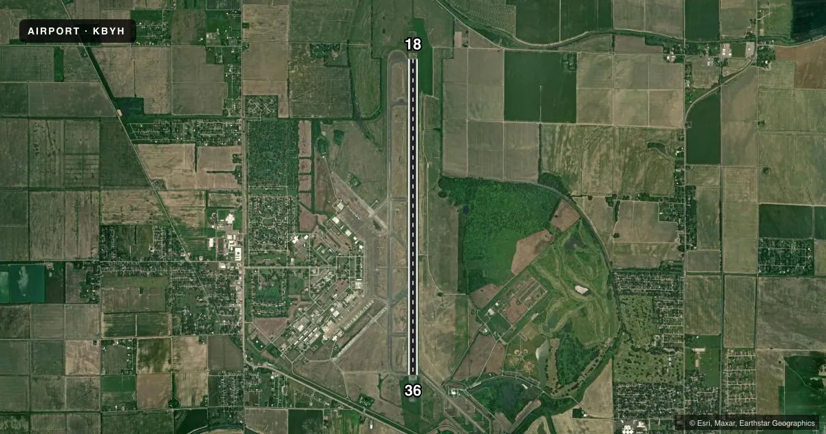
Airport sketch
Runways drawn to scale from FAA survey coordinates, rendered over satellite imagery. Not for navigation.
Approaches & charts
ILS · 1
Services on the field
Fuel grades, oxygen, maintenance, ramp storage and lighting — as declared to the FAA by the airport operator.
Fuel & services
- Fuel
- 100LLA
- Airframe repair
- Major
Ramp & ground
- Transient storage
- Tie-down
- Lighting schedule
- SEE RMK
- Beacon schedule
- SS-SR
- Beacon
- White / Green (civil land)(WG)
- Wind indicator
- Lighted
- Segmented circle
- Yes
Fuel & FBOs
Cheapest 100LL and Jet A on the field and nearby. Always confirm with the FBO before taxi.
Airport notes
Surface conditions, obstructions, local procedures, lighting outages and other notes published with each FAA cycle.
General notes
- NO FEE CHRGD FOR SVC AFT HRS CTC/LV MSG - 870-532-5628.
- FOR CD CTC MEMPHIS ARTCC AT 901-368-8453/8449.
- TWY A BTN TWY B AND TWY D TKOF AND LDG AVBL TO MIL ACFT.
Lighting notes
- DUSK-DAWN. ACTVT HIRL RY 18/36 - CTAF.
Fuel notes
- 100LLFUEL AVBL 24 HRS SELF SERVE WITH CREDIT CARD (100 LL)
Runway surface & condition
- 18/36NSTD HIRL; LCTD 77 FT FM RWY EDGE & NSTD DSTC FM CNTRLN. DPT PRECEPTION PROBLEMS MAY EXIST DURG PDS OF DARKNESS.
Approach & departure obstructions
- 36RY 36 V4L OTS INDEFLY.
Other notes
- THIS AIRPORT HAS BEEN SURVEYED BY THE NATIONAL GEODETIC SURVEY.
- 1ARPT UNATNDD HOLS.
VFR map & nearby airports
VFR sectional. Tap any ICAO chip to open that airport.
Key facts · KBYH
Answer card- ICAO
- KBYH
- Name
- ARKANSAS INTL
- Location
- BLYTHEVILLE, ARKANSAS
- Elevation
- 254.1 ft MSL
- Traffic pattern altitude
- 1,254.1 ft MSL (1,000 AGL)
- Control tower
- Non-towered (use CTAF)
- Total runways
- 1
- Longest runway
- 18/36 · 11,602 ft
- Published ILS approaches
- 1
- Published frequencies
- 2
- Magnetic variation
- 1°
- Current flight rules
- VFR
- Current wind
- 190° at 4 kt
- Favored runway now
- RWY 18
Arkansas International Airport sits in Blytheville, Arkansas. Field elevation is 254.1 ft MSL. The airport has one runway, 18/36, which is 11,602 ft long. It is a non-towered field, so use CTAF 122.7 for traffic calls and runway coordination.
The field has one ILS approach to runway 18. Pattern altitude is not published in the facts, so use the standard 1,000 ft AGL unless current airport information says otherwise. That puts the pattern at 1,254.1 ft MSL based on the listed field elevation. Runway 36 has a visual approach slope indicator that is out of service indefinitely, so plan your descent and stabilization with that in mind.
Arkansas International Airport is served by Arkansas International Airport on the field. It carries AVGAS 100LL and Jet A Prist. Fuel is available 24 hours self serve with credit card for 100 low lead. The airport is unattended on holidays. For clearance delivery, contact Memphis ARTCC at the published phone numbers before departure. Night operations deserve extra attention here because the high intensity runway lights are activated from dusk to dawn by using CTAF. The lights are also set back from the runway edge in a nonstandard way. Departure perception can be different in the dark.