METAR & TAF M28
M28 does not publish a METAR.
Showing the nearest reporting station: KTKX (KENNETT MEML) · 14.9 NM away. Conditions at M28 may differ.
METAR · KTKX
Observed 13:35Z
KTKX 271335Z AUTO 17008KT 10SM CLR 27/26 A2997 RMK AO2
- Wind
- 170° @ 8 kt
- Visibility
- 10 SM
- Temp / Dew
- 27°C / 26°C
- Altimeter
- 29.97 inHg
- Clouds
- CLR
- Density alt
- 1,710 ft
- Ceiling
- Unlimited
- Rules
- VFR
Airport info & contacts
Manager on record, flight service, ARTCC, attendance schedule and pattern altitude — published by the FAA and refreshed every 28 days.
Location
- From city
- 2 NM E
- VFR sectional
- ST LOUIS
- ARTCC
- ZME · MEMPHIS
- NOTAM facility
- STL (NOTAM-D)
Airport manager
- Name
- CHRIS COBB
- Phone
- 573-359-0500
- Address
- PO BOX 540, PO BOX 540, HAYTI MO 63851
Flight service · Hours
- FSS STL
- SAINT LOUIS1-800-WX-BRIEF
- Attendance
- MON-FRI · 0800-1700
- SAT · 0800-1200
Frequencies
Tap any row to copy the frequency to your clipboard.
Runways & pattern
Full pagePattern entry · RWY 18
LEFT TRAFFICRunway end performance
| End | TORA | TODA | ASDA | LDA | VGSI | Approach lights | Obstruction |
|---|---|---|---|---|---|---|---|
| 18 | — | — | — | — | — | — | 43', pline, 355' from thr, 160' R of cntrln, slope 8 |
| 36 | — | — | — | — | — | — | 10', road, 25' from thr, 125' R of cntrln, slope 2 |
Declared distances in feet. TORA = takeoff run available, TODA = takeoff distance, ASDA = accelerate-stop, LDA = landing distance.
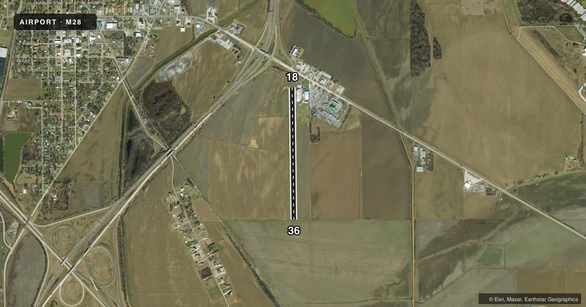
Airport sketch
Runways drawn to scale from FAA survey coordinates, rendered over satellite imagery. Not for navigation.
Approaches & charts
Services on the field
Fuel grades, oxygen, maintenance, ramp storage and lighting — as declared to the FAA by the airport operator.
Fuel & services
- Fuel
- 100LLA
- Airframe repair
- Major
- Power plant repair
- Major
- Other services
- AGRI,SALES
Ramp & ground
- Transient storage
- Tie-down
- Landing fee
- No fee published
- Wind indicator
- Yes
- Segmented circle
- No
Fuel & FBOs
Cheapest 100LL and Jet A on the field and nearby. Always confirm with the FBO before taxi.
Airport notes
Surface conditions, obstructions, local procedures, lighting outages and other notes published with each FAA cycle.
General notes
- A/G TEST FLYING.
- FARM ROAD CROSSES MIDDLE OF RY.
- CROP DUSTING ACFT ON & INVOF ARPT.
- NSTD RWY SAFETY AREA BYND EACH RWY END; INSUFFICENT LENGTH, ROADS, AND CROPS.
- FOR CD CTC MEMPHIS ARTCC AT 901-368-8453/8449.
Runway surface & condition
- 18/36NORTH 475' OF RY 155' WIDE.
Approach & departure obstructions
- 18RWY 18/36 WHITE NON-FRANGIBLE REFLECTORS AND YELLOW CONES MARK EDGE OF RWY; RWY ENDS NOT MKD, DTHR MKD WITH GROUPS OF YELLOW CONES.
- 18RWY 18 APPROACH SLOPE RATIO 15:1 TO DSPLCD THR
- 36APCH SLOPE RATIO 10:1 TO DSPLCD THR.
Other notes
- MARKED WITH YELLOW CONES ON EAST SIDE OF RUNWAY
- 18/361090 FT BY 20 FT PAVED CONC/ASPH 110 FT SOUTH OF RWY 18 THLD. PAVED AREA IS 5 FT - 20 FT EAST OF CNTRLN.
VFR map & nearby airports
VFR sectional. Tap any ICAO chip to open that airport.
Key facts · M28
Answer card- ICAO
- M28
- Name
- MID CONTINENT
- Location
- HAYTI, MISSOURI
- Elevation
- 268 ft MSL
- Traffic pattern altitude
- 1,268 ft MSL (1,000 AGL)
- Control tower
- Non-towered (use CTAF)
- Total runways
- 1
- Longest runway
- 18/36 · 3,420 ft
- Published ILS approaches
- 0
- Published frequencies
- 1
- Magnetic variation
- 2°
- Current flight rules
- VFR
- Current wind
- 170° at 8 kt
- Favored runway now
- RWY 18
Mid Continent Airport sits in Hayti, Missouri. Field elevation is 268 ft MSL. The airport has one runway, 18/36, with a longest length of 3,420 ft. It is not towered. CTAF is 122.9. No ILS approaches are published here.
Pattern altitude is not published. Use 1,000 ft AGL for light piston traffic unless the current Chart Supplement says otherwise. The published remarks matter here. A farm road crosses the middle of the runway. Crop dusting aircraft operate on and near the field. Air-to-ground test flying also occurs. Runway 18/36 has cones and white non-frangible reflectors marking the edges. The runway ends are not marked. The displaced threshold is marked with groups of yellow cones.
There are no on-field FBOs listed, so plan to verify services before departure. The airport also has a nonstandard runway safety area beyond each end with roads and crops nearby. The north 475 ft of the runway is wider than the rest of the strip. Clearance delivery is handled through Memphis ARTCC by phone when needed. This is a field where a careful taxi and takeoff brief matters. Watch for the mixed asphalt and turf surface. Watch the displaced thresholds. Watch for local traffic that may be working low and close to the runway.