METAR & TAF KEIW
KEIW does not publish a METAR.
Showing the nearest reporting station: KMAW (MALDEN RGNL) · 19.3 NM away. Conditions at KEIW may differ.
METAR · KMAW
Observed 13:35Z
KMAW 271335Z AUTO 20007KT 10SM CLR 27/22 A2997 RMK AO1
- Wind
- 200° @ 7 kt
- Visibility
- 10 SM
- Temp / Dew
- 27°C / 22°C
- Altimeter
- 29.97 inHg
- Clouds
- CLR
- Density alt
- 1,745 ft
- Ceiling
- Unlimited
- Rules
- VFR
Airport info & contacts
Manager on record, flight service, ARTCC, attendance schedule and pattern altitude — published by the FAA and refreshed every 28 days.
Location
- From city
- 4 NM SW
- VFR sectional
- ST LOUIS
- ARTCC
- ZME · MEMPHIS
- NOTAM facility
- STL (NOTAM-D)
Airport manager
- Name
- KEENAN CARLISLE
- Phone
- 573-748-0302
- Address
- P.O. BOX 173, NEW MADRID MO 63866
Flight service · Hours
- FSS STL
- SAINT LOUIS1-800-WX-BRIEF
- Attendance
- OCT-MAR · MON-FRI · 0800-1630
- APR-SEP · MON-FRI · 0800-1730
- SAT-SUN · 0900-1630
Frequencies
Tap any row to copy the frequency to your clipboard.
Runways & pattern
Full pagePattern entry · RWY 18
LEFT TRAFFICRunway end performance
| End | TORA | TODA | ASDA | LDA | VGSI | Approach lights | Obstruction |
|---|---|---|---|---|---|---|---|
| 18 | — | — | — | — | — | — | 15', road, 300' from thr, 250' R of cntrln, slope 6 |
| 36 | — | — | — | — | — | — | 22', trees, 550' from thr, 300' R of cntrln, slope 15 |
Declared distances in feet. TORA = takeoff run available, TODA = takeoff distance, ASDA = accelerate-stop, LDA = landing distance.
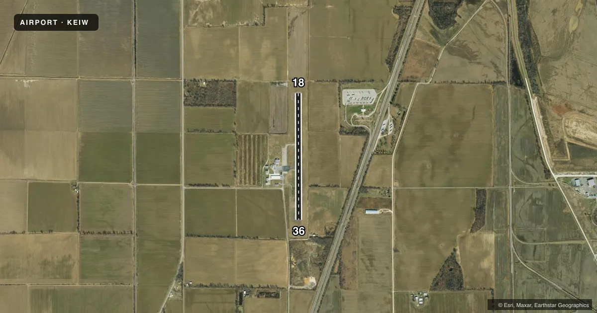
Airport sketch
Runways drawn to scale from FAA survey coordinates, rendered over satellite imagery. Not for navigation.
Approaches & charts
Services on the field
Fuel grades, oxygen, maintenance, ramp storage and lighting — as declared to the FAA by the airport operator.
Fuel & services
- Fuel
- 100LL
- Power plant repair
- Not available
- Other services
- AGRI
Ramp & ground
- Transient storage
- Tie-down
- Hangar
- Landing fee
- No fee published
- Customs
- Not available
- Lighting schedule
- SEE RMK
- Beacon schedule
- SS-SR
- Beacon
- White / Green (civil land)(WG)
- Wind indicator
- Lighted
- Segmented circle
- Yes
Fuel & FBOs
Cheapest 100LL and Jet A on the field and nearby. Always confirm with the FBO before taxi.
Airport notes
Surface conditions, obstructions, local procedures, lighting outages and other notes published with each FAA cycle.
General notes
- CROP DUSTING ACFT ON & INVOF ARPT.
- WATERFOWL INVOF ARPT.
- FOR CD CTC MEMPHIS ARTCC AT 901-368-8453/8449.
Lighting notes
- MIRL RWY 18/36 PRESET ON MED INTST; TO INCR INTST & ACTVT MIRL RWY 18/36 - CTAF.
Fuel notes
- 100LLFOR SVC AFT HRS, CALL ARPT MGR AT (573) 643-2403 OR (573) 934-3734.
Other notes
- UNICOM UNMON.
- MANAGERCOUNTY CLERK.
VFR map & nearby airports
VFR sectional. Tap any ICAO chip to open that airport.
Key facts · KEIW
Answer card- ICAO
- KEIW
- Name
- COUNTY MEML
- Location
- NEW MADRID, MISSOURI
- Elevation
- 295.8 ft MSL
- Traffic pattern altitude
- 1,295.8 ft MSL (1,000 AGL)
- Control tower
- Non-towered (use CTAF)
- Total runways
- 1
- Longest runway
- 18/36 · 3,200 ft
- Published ILS approaches
- 0
- Published frequencies
- 2
- Magnetic variation
- 0°
- Current flight rules
- VFR
- Current wind
- 200° at 7 kt
- Favored runway now
- RWY 18
County Meml Airport is in New Madrid, Missouri. The field elevation is 295.8 ft MSL. It has one runway, 18/36, which is 3,200 ft of asphalt. There is no control tower. CTAF and UNICOM are both 122.8. UNICOM is unmonitored.
No ILS approaches are published here. The pattern altitude is not published, so plan on the standard 1,000 ft AGL for light piston traffic unless the current Chart Supplement says otherwise. Magnetic variation is 0°, so the runway numbers line up with the published headings.
Hampton's Flying Service is on the field. It carries AVGAS 100LL. For after-hours fuel service, call the airport manager or the FBO by phone before you go. The published remarks also note medium intensity runway lights on 18/36. Use CTAF to increase intensity and activate the lights. That matters if you are arriving after dark.
First-time pilots should also watch for waterfowl in the area. Crop dusting aircraft are on and near the airport too. If you need clearance delivery, contact Memphis ARTCC directly. Check the current FAA Chart Supplement for any additional local procedures before you launch.