METAR & TAF 34M
34M does not publish a METAR.
Showing the nearest reporting station: KMAW (MALDEN RGNL) · 6.8 NM away. Conditions at 34M may differ.
METAR · KMAW
Observed 13:35Z
KMAW 271335Z AUTO 20007KT 10SM CLR 27/22 A2997 RMK AO1
- Wind
- 200° @ 7 kt
- Visibility
- 10 SM
- Temp / Dew
- 27°C / 22°C
- Altimeter
- 29.97 inHg
- Clouds
- CLR
- Density alt
- 1,730 ft
- Ceiling
- Unlimited
- Rules
- VFR
Airport info & contacts
Manager on record, flight service, ARTCC, attendance schedule and pattern altitude — published by the FAA and refreshed every 28 days.
Location
- From city
- 3 NM E
- VFR sectional
- ST LOUIS
- ARTCC
- ZME · MEMPHIS
- NOTAM facility
- STL (NOTAM-D)
Airport manager
- Name
- RANDALL BAKER
- Phone
- 573-246-2541
- Address
- 302 W GRAND, CAMPBELL MO 63933
Flight service · Hours
- FSS STL
- SAINT LOUIS1-800-WX-BRIEF
- Attendance
- 0800-1700
Frequencies
Tap any row to copy the frequency to your clipboard.
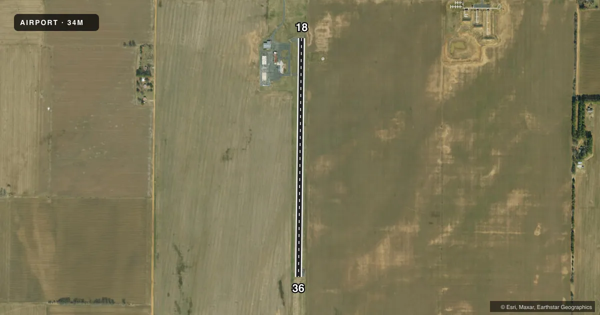
Runways & pattern
Full pagePattern entry · RWY 18
LEFT TRAFFICAirport sketch
Runways drawn to scale from FAA survey coordinates, rendered over satellite imagery. Not for navigation.
Approaches & charts
Services on the field
Fuel grades, oxygen, maintenance, ramp storage and lighting — as declared to the FAA by the airport operator.
Fuel & services
- Fuel
- Not available
- Other services
- AGRI,INSTR
Ramp & ground
- Transient storage
- Tie-down
- Landing fee
- No fee published
- Customs
- Not available
- Lighting schedule
- SS-SR
- Beacon schedule
- SS-SR
- Beacon
- White / Green (civil land)(WG)
- Wind indicator
- Yes
- Segmented circle
- Yes
Fuel & FBOs
Cheapest 100LL and Jet A on the field and nearby. Always confirm with the FBO before taxi.
Airport notes
Surface conditions, obstructions, local procedures, lighting outages and other notes published with each FAA cycle.
General notes
- CROP DUSTING ACFT ON & INVOF ARPT.
- FOR CD CTC MEMPHIS ARTCC AT 901-368-8453/8449.
Runway surface & condition
- 18/36RWY 18/36 NSTD LIRL
Other notes
- EXISTED PRIOR TO 1959.
VFR map & nearby airports
VFR sectional. Tap any ICAO chip to open that airport.
Key facts · 34M
Answer card- ICAO
- 34M
- Name
- CAMPBELL MUNI
- Location
- CAMPBELL, MISSOURI
- Elevation
- 284 ft MSL
- Traffic pattern altitude
- 1,284 ft MSL (1,000 AGL)
- Control tower
- Non-towered (use CTAF)
- Total runways
- 1
- Longest runway
- 18/36 · 3,000 ft
- Published ILS approaches
- 0
- Published frequencies
- 1
- Magnetic variation
- 2°
- Current flight rules
- VFR
- Current wind
- 200° at 7 kt
- Favored runway now
- RWY 18
Campbell Muni is in Campbell, Missouri. The field elevation is 284 ft MSL. It has one runway. Runway 18/36 is 3,000 ft long and paved with asphalt. There is no control tower. CTAF is 122.9.
No ILS approaches are published here. The pattern altitude is not published in the facts, so use the standard 1,000 ft AGL for light piston aircraft unless the current FAA Chart Supplement says otherwise. The runway has nonstandard low-intensity lighting. Plan for that if you expect a brighter light system at night. Crop dusting aircraft also operate on and near the airport. That makes local traffic awareness important, especially on departure and in the pattern.
There are no on-field FBOs listed in the facts. Contact the airport operator directly before arrival, or call the field on CTAF for current FBO availability. For clearance delivery, the published remark points pilots to Memphis ARTCC. If you are planning IFR or night operations, check the current FAA Chart Supplement for any updates before you go. The airport sits in a low-elevation part of Missouri, so terrain is not the main issue. Traffic mix and runway lighting are the bigger items to brief.