METAR & TAF KDXE
KDXE does not publish a METAR.
Showing the nearest reporting station: KMAW (MALDEN RGNL) · 10.9 NM away. Conditions at KDXE may differ.
METAR · KMAW
Observed 15:15Z
KMAW 271515Z AUTO 25005KT 10SM CLR 30/24 A2994 RMK AO1
- Wind
- 250° @ 5 kt
- Visibility
- 10 SM
- Temp / Dew
- 30°C / 24°C
- Altimeter
- 29.94 inHg
- Clouds
- CLR
- Density alt
- 2,153 ft
- Ceiling
- Unlimited
- Rules
- VFR
Airport info & contacts
Manager on record, flight service, ARTCC, attendance schedule and pattern altitude — published by the FAA and refreshed every 28 days.
Location
- From city
- 2 NM SE
- VFR sectional
- ST LOUIS
- ARTCC
- ZME · MEMPHIS
- NOTAM facility
- STL (NOTAM-D)
Airport manager
- Name
- MIKE WILLIAMS
- Phone
- 573-624-0018
- Address
- 301 E. STODDARD STREET, DEXTER MO 63841
Flight service · Hours
- FSS STL
- SAINT LOUIS1-800-WX-BRIEF
- Attendance
- IREG · IREG
Frequencies
Tap any row to copy the frequency to your clipboard.
Runways & pattern
Full pagePattern entry · RWY 18
LEFT TRAFFICRunway end performance
| End | TORA | TODA | ASDA | LDA | VGSI | Approach lights | Obstruction |
|---|---|---|---|---|---|---|---|
| 18 | — | — | — | — | PAPI 2-box left(2.98°) | — | 84', tree, 2300' from thr, 275' R of cntrln, slope 25 |
| 36 | — | — | — | — | PAPI 2-box left(3.01°) | — | — |
Declared distances in feet. TORA = takeoff run available, TODA = takeoff distance, ASDA = accelerate-stop, LDA = landing distance.
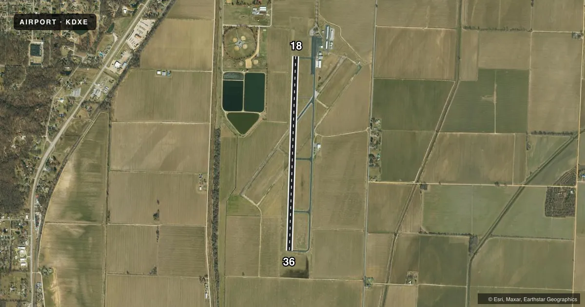
Airport sketch
Runways drawn to scale from FAA survey coordinates, rendered over satellite imagery. Not for navigation.
Approaches & charts
Services on the field
Fuel grades, oxygen, maintenance, ramp storage and lighting — as declared to the FAA by the airport operator.
Fuel & services
- Fuel
- 100LLA
- Oxygen (bottled)
- Not available
- Oxygen (bulk)
- Not available
- Airframe repair
- Minor
- Power plant repair
- Minor
Ramp & ground
- Transient storage
- Tie-down
- Landing fee
- No fee published
- Customs
- Not available
- Lighting schedule
- SEE RMK
- Beacon schedule
- SS-SR
- Beacon
- White / Green (civil land)(WG)
- Wind indicator
- Lighted
- Segmented circle
- Yes
Fuel & FBOs
Cheapest 100LL and Jet A on the field and nearby. Always confirm with the FBO before taxi.
Airport notes
Surface conditions, obstructions, local procedures, lighting outages and other notes published with each FAA cycle.
General notes
- CROP DUSTING ACFT ON & INVOF ARPT.
- MODEL AIRPLANE ACTIVITY ON & INVOF ARPT.
- FOR CD CTC MEMPHIS ARTCC AT 901-368-8453/8449.
Lighting notes
- ACTVT PAPI RWY 18 & 36; MIRL RWY 18/36 - CTAF.
- ULTRALIGHT ACTIVITY ON & INVOF ARPT.
Fuel notes
- 100LL24-HR SELF-SERVICE CREDIT CARD FOR FUEL.
- A24-HR SELF-SERVICE CREDIT CARD FOR FUEL
Other notes
- PROVIDED THE APPROACH TO EACH RWY IS MAINTAINED FOR A MINIMUM 20:1 GLIDE SLOPE AND THE TRANSITIONAL SURFACE BE MAINTAINED FOR A 7:1 SLOPE.
- UNICOM UNMON.
VFR map & nearby airports
VFR sectional. Tap any ICAO chip to open that airport.
Key facts · KDXE
Answer card- ICAO
- KDXE
- Name
- DEXTER MUNI
- Location
- DEXTER, MISSOURI
- Elevation
- 304.4 ft MSL
- Traffic pattern altitude
- 1,304.4 ft MSL (1,000 AGL)
- Control tower
- Non-towered (use CTAF)
- Total runways
- 1
- Longest runway
- 18/36 · 5,000 ft
- Published ILS approaches
- 0
- Published frequencies
- 2
- Magnetic variation
- 0°
- Current flight rules
- VFR
- Current wind
- 250° at 5 kt
- Favored runway now
- RWY 18
Dexter Muni sits in Dexter, Missouri. Field elevation is 304.4 ft MSL. The airport has one runway, 18/36, at 5,000 ft asphalt. It is an untowered field. CTAF and UNICOM are both 122.7. UNICOM is unmonitored. No ILS approaches are published here.
Pattern altitude is not published. Use the standard 1,000 ft AGL for light piston operations unless the current Chart Supplement says otherwise. The field has 24-hour self-serve fuel with credit card. The on-field FBO is Dexter Municipal Airport. It carries 100LL and Jet A. Call (573) 624-4377 for current service details.
A few operational notes matter here. Crop dusting aircraft operate on and near the airport. Model airplane activity and ultralight activity also occur on and near the field. Runway markings on both 18 and 36 are severely faded, so plan for a careful visual scan on arrival and departure. PAPI is available on 18 and 36. Medium intensity runway lights are also on 18 and 36. They are controlled by CTAF. For clearance delivery, contact Memphis ARTCC before departure. The published approach surfaces are protected, so stay aware of terrain and obstacle clearance on final.