METAR & TAF KSIK
Current METAR
Observed 15:55Z
KSIK 271555Z AUTO 26007KT 10SM CLR 31/27 A2990 RMK AO2 T03060269 $
- Wind
- 260° @ 7 kt
- Visibility
- 10 SM
- Temp / Dew
- 31°C / 27°C
- Altimeter
- 29.90 inHg
- Clouds
- CLR
- Density alt
- 2,335 ft
- Ceiling
- Unlimited
- Rules
- VFR
Airport info & contacts
Manager on record, flight service, ARTCC, attendance schedule and pattern altitude — published by the FAA and refreshed every 28 days.
Location
- From city
- 2 NM NE
- VFR sectional
- ST LOUIS
- ARTCC
- ZME · MEMPHIS
- NOTAM facility
- STL (NOTAM-D)
Airport manager
- Name
- SIKESTON AVIATION
- Phone
- 573-471-2037
- Address
- 160 AIRPORT DR, SIKESTON MO 63801
Flight service · Hours
- FSS STL
- SAINT LOUIS1-800-WX-BRIEF
- Attendance
- 0800-1700
Frequencies
Tap any row to copy the frequency to your clipboard.
Runways & pattern
Full pagePattern entry · RWY 21
LEFT TRAFFICRunway end performance
| End | TORA | TODA | ASDA | LDA | VGSI | Approach lights | Obstruction |
|---|---|---|---|---|---|---|---|
| 03 | — | — | — | — | PAPI 4-box left(3°) | — | 25', tree, 1030' from thr, 270' R of cntrln, slope 33 |
| 21 | — | — | — | — | PAPI 4-box left(3°) | — | 35', trees, 1225' from thr, 358' R of cntrln, slope 29 |
Declared distances in feet. TORA = takeoff run available, TODA = takeoff distance, ASDA = accelerate-stop, LDA = landing distance.
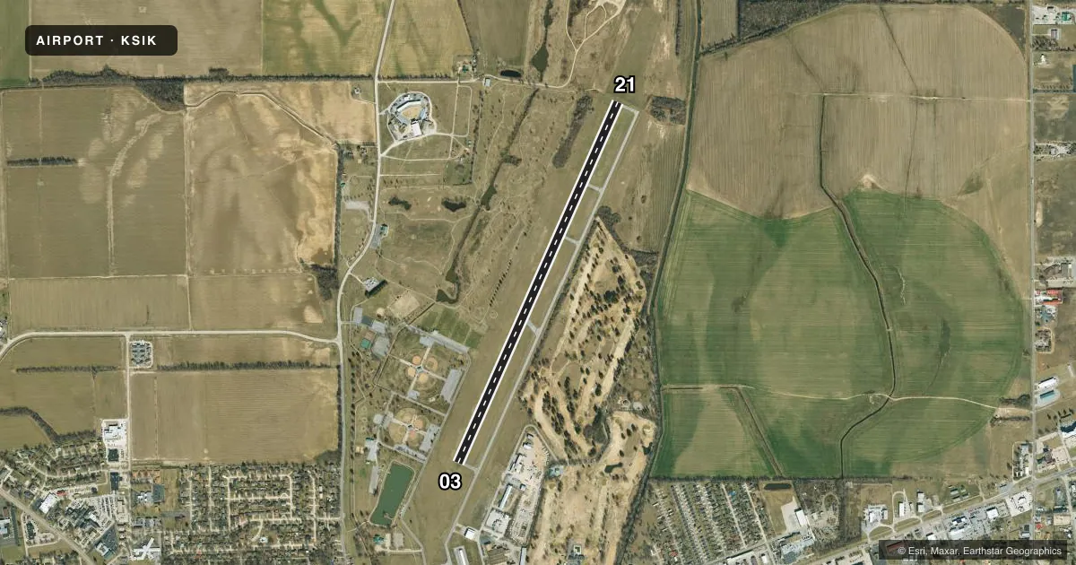
Airport sketch
Runways drawn to scale from FAA survey coordinates, rendered over satellite imagery. Not for navigation.
Approaches & charts
Services on the field
Fuel grades, oxygen, maintenance, ramp storage and lighting — as declared to the FAA by the airport operator.
Fuel & services
- Fuel
- 100LLA
- Oxygen (bottled)
- Not available
- Oxygen (bulk)
- Not available
- Other services
- AGRI,INSTR,RNTL,SURV
Ramp & ground
- Transient storage
- Tie-down
- Hangar
- Landing fee
- No fee published
- Customs
- Not available
- Lighting schedule
- SEE RMK
- Beacon schedule
- SS-SR
- Beacon
- White / Green (civil land)(WG)
- Wind indicator
- Lighted
- Segmented circle
- Yes
Fuel & FBOs
Cheapest 100LL and Jet A on the field and nearby. Always confirm with the FBO before taxi.
Airport notes
Surface conditions, obstructions, local procedures, lighting outages and other notes published with each FAA cycle.
General notes
- NUMEROUS BIRDS INVOF ARPT.
- FOR CD CTC MEMPHIS ARTCC AT 901-368-8453/8449.
Lighting notes
- MIRL RWY 03/21 PRESET ON LOW INTST; TO INCR INTST AND ACTVT REIL RWY 21 - CTAF. PAPI RWYS 03 & 21 OPER CONTINUOUSLY.
- ULTRALIGHT ACTIVITY ON & INVOF ARPT.
Fuel notes
- 100LL24-HR AUTOMATIC CREDIT CARD FUELING SYSTEM FOR 100LL.
Runway surface & condition
- 03/21PCR VALUE: 310/F/D/X/T
Approach & departure obstructions
- 03RWY 3 MARKINGS SEVERELY FADED
- 21RWY 21 MARKINGS SEVERELY FADED
Other notes
- THIS AIRPORT HAS BEEN SURVEYED BY THE NATIONAL GEODETIC SURVEY.
VFR map & nearby airports
VFR sectional. Tap any ICAO chip to open that airport.
Key facts · KSIK
Answer card- ICAO
- KSIK
- Name
- SIKESTON MEML MUNI
- Location
- SIKESTON, MISSOURI
- Elevation
- 314.8 ft MSL
- Traffic pattern altitude
- 1,314.8 ft MSL (1,000 AGL)
- Control tower
- Non-towered (use CTAF)
- Total runways
- 1
- Longest runway
- 03/21 · 5,502 ft
- Published ILS approaches
- 0
- Published frequencies
- 2
- Magnetic variation
- 2°
- Current flight rules
- VFR
- Current wind
- 260° at 7 kt
- Favored runway now
- RWY 21
Sikeston Memorial Municipal Airport sits in Sikeston, Missouri. Field elevation is 314.8 ft MSL. The airport has one runway, 03/21, which is 5,502 ft long. There is no control tower. CTAF and UNICOM are both 122.8. No ILS approaches are published here.
Pattern altitude is not published, so use the standard 1,000 ft AGL for light piston traffic unless the current Chart Supplement says otherwise. The field has medium intensity runway lights on 03/21. They come up in low intensity by default. Use the CTAF to increase intensity. Runway end identifier lights on runway 21 also activate that way. PAPI is listed for both runway ends and operates continuously. The pavement rating is published as 310/F/D/X/T. Runway 21 markings are severely faded. Runway 3 markings are also severely faded.
One on-field FBO is listed. Sikeston Memorial Municipal Airport carries 100LL and Jet A. There is also a 24-hour automatic credit card fueling system for 100LL. Expect bird activity in the area. Ultralight activity also occurs on and near the airport. For clearance delivery, Memphis ARTCC is the published contact. If you are planning a first trip in, review the current Chart Supplement before departure and be ready for an uncontrolled field with local traffic on 122.8.