METAR & TAF KCIR
Current METAR
Observed 13:35Z
KCIR 271335Z AUTO 00000KT 10SM CLR 26/23 A2995 RMK AO2 T02640229
- Wind
- 000° @ 0 kt
- Visibility
- 10 SM
- Temp / Dew
- 26°C / 23°C
- Altimeter
- 29.95 inHg
- Clouds
- CLR
- Density alt
- 1,682 ft
- Ceiling
- Unlimited
- Rules
- VFR
Airport info & contacts
Manager on record, flight service, ARTCC, attendance schedule and pattern altitude — published by the FAA and refreshed every 28 days.
Location
- From city
- 4 NM NW
- VFR sectional
- ST LOUIS
- ARTCC
- ZME · MEMPHIS
- NOTAM facility
- CIR (NOTAM-D)
Airport manager
- Name
- CHARLES WADE
- Phone
- 618-734-0600
- Address
- P O BOX 26, CAIRO IL 62914
Flight service · Hours
- FSS STL
- SAINT LOUIS1-800-WX-BRIEF
- Attendance
- MON-SAT · 0900-1700
- SUN · IRREG
Frequencies
Tap any row to copy the frequency to your clipboard.
Runways & pattern
Full pagePattern entry · RWY 14
LEFT TRAFFIC| Runway | Heading (°M) | Length | Surface | Traffic |
|---|---|---|---|---|
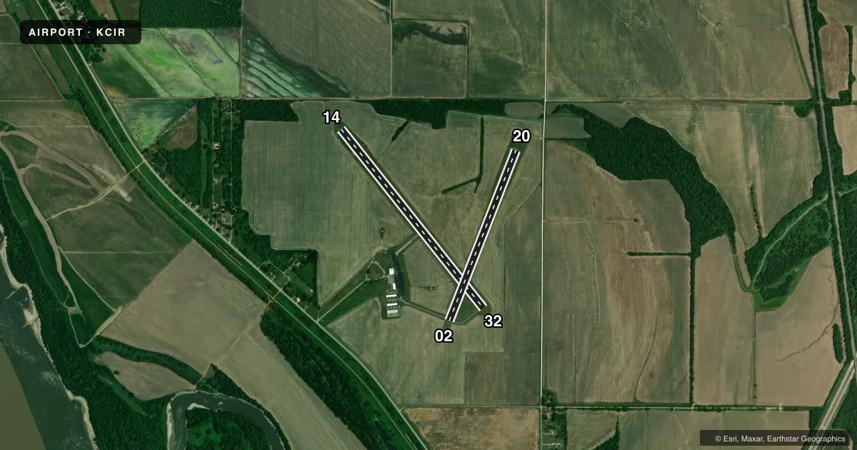
| 14/32 | 141° / 321° | 4,001 ft | ASPH | Standard L |
| 02/20 | 21° / 201° | 3,200 ft | ASPH | Standard L |
Runway end performance
| End | TORA | TODA | ASDA | LDA | VGSI | Approach lights | Obstruction |
|---|---|---|---|---|---|---|---|
| 14 | — | — | — | — | PAPI 4-box left(3°) | — | — |
Declared distances in feet. TORA = takeoff run available, TODA = takeoff distance, ASDA = accelerate-stop, LDA = landing distance.
Airport sketch
Runways drawn to scale from FAA survey coordinates, rendered over satellite imagery. Not for navigation.
Approaches & charts
Services on the field
Fuel grades, oxygen, maintenance, ramp storage and lighting — as declared to the FAA by the airport operator.
Fuel & services
- Fuel
- 100LL
- Oxygen (bottled)
- Not available
- Oxygen (bulk)
- Not available
- Airframe repair
- Not available
- Power plant repair
- Not available
Ramp & ground
- Transient storage
- Tie-down
- Hangar
- Landing fee
- No fee published
- Customs
- Not available
- Lighting schedule
- SEE RMK
- Beacon schedule
- SS-SR
- Beacon
- White / Green (civil land)(WG)
- Wind indicator
- Lighted
- Segmented circle
- Yes
Fuel & FBOs
Cheapest 100LL and Jet A on the field and nearby. Always confirm with the FBO before taxi.
Airport notes
Surface conditions, obstructions, local procedures, lighting outages and other notes published with each FAA cycle.
General notes
- FOR CD CTC MEMPHIS ARTCC AT 901-368-8453/8449.
Lighting notes
- MIRL RY 14/32 PRESET LOW INTST; TO INCR INTST ACTVT - CTAF. MIRL RY 02/20 BY PRIOR REQ ONLY CALL 618-734-0600.
Fuel notes
- 100LLSELF SVC FUEL AVBL 24 HRS.
VFR map & nearby airports
VFR sectional. Tap any ICAO chip to open that airport.
Key facts · KCIR
Answer card- ICAO
- KCIR
- Name
- CAIRO RGNL
- Location
- CAIRO, ILLINOIS
- Elevation
- 322 ft MSL
- Traffic pattern altitude
- 1,322 ft MSL (1,000 AGL)
- Control tower
- Non-towered (use CTAF)
- Total runways
- 2
- Longest runway
- 14/32 · 4,001 ft
- Published ILS approaches
- 0
- Published frequencies
- 2
- Magnetic variation
- 0°
- Current flight rules
- VFR
- Current wind
- 000° at 0 kt
- Favored runway now
- –
Cairo Regional Airport sits in Cairo, Illinois. Field elevation is 322 ft MSL. The airport has two asphalt runways. The longest is 4,001 ft on runway 14/32. There is no control tower, so use CTAF 122.8 for self-announce traffic. Pattern altitude is not published. For light piston operations, plan on the standard 1,000 ft AGL pattern unless the current Chart Supplement says otherwise.
No ILS approaches are published here. That makes current weather and your own arrival planning more important, especially if you are coming in at night or with lower ceilings. The field has one on-field FBO, Cairo Regional Airport. It carries 100LL. Self-service 100LL is available 24 hours. Runway lighting is worth a look before you go. Runway 14/32 has medium intensity lights preset to low. You can raise the intensity on CTAF. Runway 02/20 lighting is available by prior request only by calling the airport.
For a first-time arrival, keep the airport’s non-towered setup in mind. Use 122.8 for CTAF and UNICOM. Clearance delivery is handled through Memphis ARTCC by phone. Check the current Chart Supplement for any published noise or curfew restrictions before flying into the field.