METAR & TAF 0M2
0M2 does not publish a METAR.
Showing the nearest reporting station: KUCY (EVERETT-STEWART RGNL) · 18.3 NM away. Conditions at 0M2 may differ.
METAR · KUCY
Observed 06:55Z
KUCY 270655Z AUTO 00000KT 7SM FEW028 BKN036 BKN041 25/25 A2989 RMK A01
- Wind
- 000° @ 0 kt
- Visibility
- 7 SM
- Temp / Dew
- 25°C / 25°C
- Altimeter
- 29.89 inHg
- Clouds
- BKN
- Density alt
- 1,596 ft
- Ceiling
- 3,600 ft AGL
- Rules
- VFR
Airport info & contacts
Manager on record, flight service, ARTCC, attendance schedule and pattern altitude — published by the FAA and refreshed every 28 days.
Location
- From city
- 9 NM NE
- VFR sectional
- ST LOUIS
- ARTCC
- ZME · MEMPHIS
- NOTAM facility
- MKL (NOTAM-D)
Airport manager
- Name
- BILL BURNEY
- Phone
- 615-741-1680
- Address
- 7335 CENTENNIAL BLVD, NASHVILLE TN 37209
Flight service · Hours
- FSS MKL
- JACKSON1-800-WX-BRIEF
- Attendance
- Unattended
Frequencies
Tap any row to copy the frequency to your clipboard.
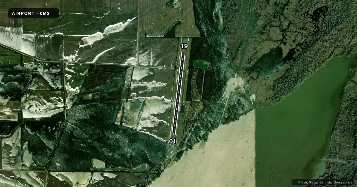
Runways & pattern
Full pagePattern entry · RWY 01
LEFT TRAFFICRunway end performance
| End | TORA | TODA | ASDA | LDA | VGSI | Approach lights | Obstruction |
|---|---|---|---|---|---|---|---|
| 01 | — | — | — | — | — | — | 35', trees, 667' from thr, 125' R of cntrln, slope 13 |
| 19 | — | — | — | — | — | — | 105', fence, 2294' from thr, 194' R of cntrln, slope 19 |
Declared distances in feet. TORA = takeoff run available, TODA = takeoff distance, ASDA = accelerate-stop, LDA = landing distance.
Airport sketch
Runways drawn to scale from FAA survey coordinates, rendered over satellite imagery. Not for navigation.
Approaches & charts
Services on the field
Fuel grades, oxygen, maintenance, ramp storage and lighting — as declared to the FAA by the airport operator.
Fuel & services
- Fuel
- Not available
- Other services
- AGRI
Ramp & ground
- Transient storage
- Tie-down
- Landing fee
- No fee published
- Customs
- Not available
- Beacon schedule
- SS-SR
- Beacon
- White / Green (civil land)(WG)
- Wind indicator
- Yes
- Segmented circle
- Yes
Fuel & FBOs
Cheapest 100LL and Jet A on the field and nearby. Always confirm with the FBO before taxi.
Airport notes
Surface conditions, obstructions, local procedures, lighting outages and other notes published with each FAA cycle.
General notes
- MNTN 2000 FT OVR LAKE E OF ARPT.
- FOR CD CTC MEMPHIS ARTCC AT 901-368-8453/8449.
Lighting notes
- OTS INDEFLY.
Other notes
- PILOT PRVD OWN TIEDOWN ROPE.
VFR map & nearby airports
VFR sectional. Tap any ICAO chip to open that airport.
Key facts · 0M2
Answer card- ICAO
- 0M2
- Name
- REELFOOT LAKE
- Location
- TIPTONVILLE, TENNESSEE
- Elevation
- 289 ft MSL
- Traffic pattern altitude
- 1,289 ft MSL (1,000 AGL)
- Control tower
- Non-towered (use CTAF)
- Total runways
- 1
- Longest runway
- 01/19 · 3,500 ft
- Published ILS approaches
- 0
- Published frequencies
- 1
- Magnetic variation
- 2°
- Current flight rules
- VFR
- Current wind
- 000° at 0 kt
- Favored runway now
- –
Reelfoot Lake Airport sits in Tiptonville, Tennessee. The field elevation is 289 ft MSL. It has one runway. Runway 01/19 is 3,500 ft of asphalt. There is no control tower. CTAF is 122.9. No ILS approaches are published.
Pattern altitude is not published in the facts block. For light piston planning, use the standard 1,000 ft AGL pattern unless the current Chart Supplement says otherwise. The airport is in a lake area, so pay attention to the published remark to maintain 2,000 ft over the lake east of the airport. Clearance delivery is handled through Memphis ARTCC at the listed phone numbers when needed. The remarks also say the field is out of service indefinitely. Verify current status with the airport operator before you go. There are no on-field FBOs listed in the facts. Pilot provides own tiedown rope.