METAR & TAF KCHQ
KCHQ does not publish a METAR.
Showing the nearest reporting station: KSIK (SIKESTON MEML MUNI) · 10.3 NM away. Conditions at KCHQ may differ.
METAR · KSIK
Observed 12:35Z
KSIK 271235Z AUTO 00000KT 10SM OVC190 25/22 A2994 RMK AO2 T02490221 $
- Wind
- 000° @ 0 kt
- Visibility
- 10 SM
- Temp / Dew
- 25°C / 22°C
- Altimeter
- 29.94 inHg
- Clouds
- OVC
- Density alt
- 1,563 ft
- Ceiling
- 19,000 ft AGL
- Rules
- VFR
Airport info & contacts
Manager on record, flight service, ARTCC, attendance schedule and pattern altitude — published by the FAA and refreshed every 28 days.
Location
- From city
- 4 NM S
- VFR sectional
- ST LOUIS
- ARTCC
- ZME · MEMPHIS
- NOTAM facility
- STL (NOTAM-D)
Airport manager
- Name
- MISSISSIPPI COUNTY COMMISSION
- Phone
- 573-683-2146
- Address
- PO BOX 369, CHARLESTON MO 63834
Flight service · Hours
- FSS STL
- SAINT LOUIS1-800-WX-BRIEF
- Attendance
- IREG
Frequencies
Tap any row to copy the frequency to your clipboard.
Runways & pattern
Full pagePattern entry · RWY 18
LEFT TRAFFICRunway end performance
| End | TORA | TODA | ASDA | LDA | VGSI | Approach lights | Obstruction |
|---|---|---|---|---|---|---|---|
| 18 | — | — | — | — | PAPI 2-box left(3°) | — | — |
| 36 | — | — | — | — | PAPI 2-box left(3°) | — | — |
Declared distances in feet. TORA = takeoff run available, TODA = takeoff distance, ASDA = accelerate-stop, LDA = landing distance.
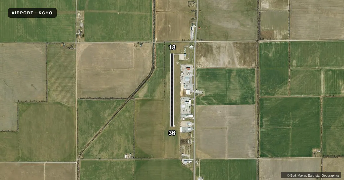
Airport sketch
Runways drawn to scale from FAA survey coordinates, rendered over satellite imagery. Not for navigation.
Approaches & charts
Services on the field
Fuel grades, oxygen, maintenance, ramp storage and lighting — as declared to the FAA by the airport operator.
Fuel & services
- Fuel
- Not available
- Oxygen (bottled)
- Not available
- Oxygen (bulk)
- Not available
- Other services
- AGRI
Ramp & ground
- Transient storage
- Tie-down
- Landing fee
- No fee published
- Customs
- Not available
- Lighting schedule
- SEE RMK
- Beacon schedule
- SS-SR
- Beacon
- White / Green (civil land)(WG)
- Wind indicator
- Lighted
- Segmented circle
- Yes
Fuel & FBOs
Cheapest 100LL and Jet A on the field and nearby. Always confirm with the FBO before taxi.
Airport notes
Surface conditions, obstructions, local procedures, lighting outages and other notes published with each FAA cycle.
General notes
- ULTRALIGHT & CROP DUSTING ACFT ON & INVOF ARPT.
- FOR CD CTC MEMPHIS ARTCC AT 901-368-8453/8449.
Lighting notes
- ACTVT REIL RWY 18 & 36; MIRL NSTD RWY 18/36 PRESET MED INTST; TO INCR INTST - CTAF. PAPI RWY 18 & 36 ON CONSLY.
Runway surface & condition
- 18/36RWY 18/36 INCORRECT NUMBER OF THLD LGTS EACH RWY END.
Approach & departure obstructions
- 18SMALL TREE 10 FT TALL 141 FT FM RWY 18 THLD, 90 FT RIGHT
- 18OTS INDEF
- 36OTS INDEF
- 18RWY 18 MARKINGS FADED.
- 36RWY 36 MARKINGS FADED.
- 18OTS INDEFINITELY
- 36OTS INDEF
Other notes
- THIS AIRPORT HAS BEEN SURVEYED BY THE NATIONAL GEODETIC SURVEY.
VFR map & nearby airports
VFR sectional. Tap any ICAO chip to open that airport.
Key facts · KCHQ
Answer card- ICAO
- KCHQ
- Name
- MISSISSIPPI COUNTY
- Location
- CHARLESTON, MISSOURI
- Elevation
- 313 ft MSL
- Traffic pattern altitude
- 1,313 ft MSL (1,000 AGL)
- Control tower
- Non-towered (use CTAF)
- Total runways
- 1
- Longest runway
- 18/36 · 3,196 ft
- Published ILS approaches
- 0
- Published frequencies
- 1
- Magnetic variation
- 2°
- Current flight rules
- VFR
- Current wind
- 000° at 0 kt
- Favored runway now
- –
Mississippi County Airport sits in Charleston, Missouri. Field elevation is 313 ft MSL. The airport has one runway. Runway 18/36 is 3,196 ft long and asphalt. There is no control tower. CTAF is 122.9. No ILS approaches are published here.
Pattern altitude is not published. Use 1,000 ft AGL for light piston operations unless the current FAA Chart Supplement says otherwise. The field is not a busy metro airport, but you should still expect local traffic. Ultralights and crop dusters operate on and near the airport. Clearance delivery for IFR departures goes through Memphis ARTCC by phone.
Published remarks matter here. Runway end identifier lights are active. Medium intensity runway edge lights are installed on 18/36. The visual glide slope indicators are out of service indefinitely. Runway 18 and Runway 36 markings are faded. There is also a small tree near the Runway 18 threshold. Runway 18/36 has incorrect threshold light counts at each end. No on-field FBOs are listed, so verify fuel and service options with the airport operator or the FBO directly by phone before you go.