METAR & TAF M85
M85 does not publish a METAR.
Showing the nearest reporting station: KMAW (MALDEN RGNL) · 10.2 NM away. Conditions at M85 may differ.
METAR · KMAW
Observed 15:15Z
KMAW 271515Z AUTO 25005KT 10SM CLR 30/24 A2994 RMK AO1
- Wind
- 250° @ 5 kt
- Visibility
- 10 SM
- Temp / Dew
- 30°C / 24°C
- Altimeter
- 29.94 inHg
- Clouds
- CLR
- Density alt
- 2,109 ft
- Ceiling
- Unlimited
- Rules
- VFR
Airport info & contacts
Manager on record, flight service, ARTCC, attendance schedule and pattern altitude — published by the FAA and refreshed every 28 days.
Location
- From city
- 1 NM SE
- VFR sectional
- ST LOUIS
- ARTCC
- ZME · MEMPHIS
- NOTAM facility
- STL (NOTAM-D)
Airport manager
- Name
- JOSHUA ATCHLEY
- Phone
- 573-225-5225
- Address
- 109 MAIN ST., PO BOX 396, GIDEON MO 63848
Flight service · Hours
- FSS STL
- SAINT LOUIS1-800-WX-BRIEF
- Attendance
- IREG
Frequencies
Tap any row to copy the frequency to your clipboard.
Runways & pattern
Full pagePattern entry · RWY 33
LEFT TRAFFICRunway end performance
| End | TORA | TODA | ASDA | LDA | VGSI | Approach lights | Obstruction |
|---|---|---|---|---|---|---|---|
| 15 | — | — | — | — | — | — | 43', tree, 750' from thr, 300' R of cntrln, slope 12 |
| 33 | — | — | — | — | — | — | 13', road, 330' from thr, 250' R of cntrln, slope 10 |
Declared distances in feet. TORA = takeoff run available, TODA = takeoff distance, ASDA = accelerate-stop, LDA = landing distance.
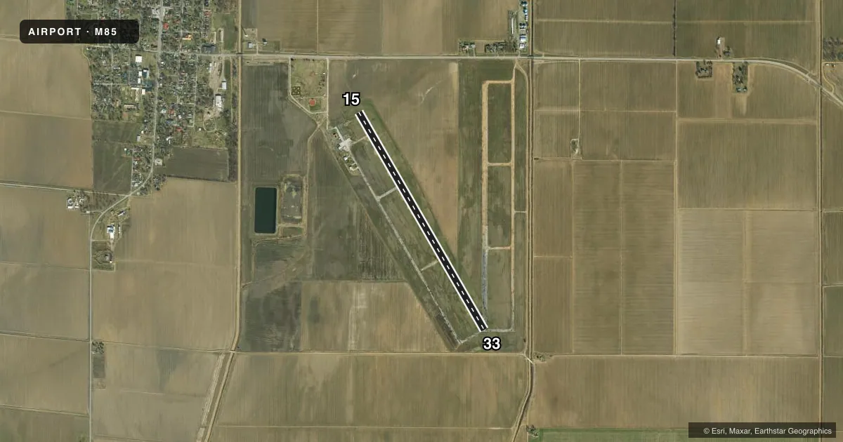
Airport sketch
Runways drawn to scale from FAA survey coordinates, rendered over satellite imagery. Not for navigation.
Approaches & charts
Services on the field
Fuel grades, oxygen, maintenance, ramp storage and lighting — as declared to the FAA by the airport operator.
Fuel & services
- Fuel
- Not available
- Other services
- AGRI
Ramp & ground
- Transient storage
- Tie-down
- Landing fee
- No fee published
- Customs
- Not available
- Wind indicator
- Yes
- Segmented circle
- Yes
Fuel & FBOs
Cheapest 100LL and Jet A on the field and nearby. Always confirm with the FBO before taxi.
Airport notes
Surface conditions, obstructions, local procedures, lighting outages and other notes published with each FAA cycle.
General notes
- N TWY TO RY 15 THLD CLSD; S TWY N OF RY 33 THLD CLSD.
- CROP DUSTING & ULTRALIGHT ACFT ON & INVOF ARPT.
- RY N/S CLSD; USED FOR FLYING OF MODEL PLANES.
- ARPT CLSD DAILY SS-SR, EXCP HELICOPTER OPNS.
- GRASS GROWING IN CRACKS ON PARL TWY.
- FOR CD CTC MEMPHIS ARTCC AT 901-368-8453/8449.
Runway surface & condition
- 15/33WIDTH VARIES FM 58-60 FT.
Approach & departure obstructions
- 15RWY MARKINGS SEVERLY FADED
- 33RWY MARKINGS SEVERLY FADED
Other notes
- THIS AIRPORT HAS BEEN SURVEYED BY THE NATIONAL GEODETIC SURVEY.
- ESTABD PRIOR TO OCT 1959.
VFR map & nearby airports
VFR sectional. Tap any ICAO chip to open that airport.
Key facts · M85
Answer card- ICAO
- M85
- Name
- GIDEON MEML
- Location
- GIDEON, MISSOURI
- Elevation
- 269 ft MSL
- Traffic pattern altitude
- 1,269 ft MSL (1,000 AGL)
- Control tower
- Non-towered (use CTAF)
- Total runways
- 1
- Longest runway
- 15/33 · 4,504 ft
- Published ILS approaches
- 0
- Published frequencies
- 1
- Magnetic variation
- 2°
- Current flight rules
- VFR
- Current wind
- 250° at 5 kt
- Favored runway now
- RWY 33
M85 is in Gideon, Missouri. The field elevation is 269 ft MSL. It has one runway, 15/33, which is 4,504 ft long and asphalt. There is no control tower. CTAF is 122.9. No ILS approaches are published. The airport is closed daily from sunset to sunrise except for helicopter operations.
The published pattern altitude is not listed, so use the standard 1,000 ft AGL unless current local guidance says otherwise. That puts the pattern at about 1,269 ft MSL based on the field elevation. Runway 15 and runway 33 markings are severely faded. The runway width varies from 58 to 60 ft. The north taxiway to runway 15 is closed. The south taxiway north of runway 33 is closed. Grass is growing in cracks on the parallel taxiway.
There are no on-field FBOs listed. Crop dusting and ultralight aircraft operate on and near the airport. That makes a good traffic scan important on arrival and departure. If you need clearance delivery, contact Memphis ARTCC at the numbers in the Chart Supplement. For a first-time stop, check the current FAA Chart Supplement before you go. The published remarks also show the field has been surveyed by the National Geodetic Survey.